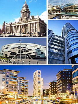
Leeds is a ceety an metropolitan borough in Wast Yorkshire, Ingland. In 2001 Leeds' main urban subdiveesion haed a population o 443,247, while the entire ceety haed a population o 770,800 (2008 est.). Leeds is the cultural, financial an commercial hert of the Wast Yorkshire Urban Aurie, which at the 2001 census haed a population o 1.5 million, an the Leeds ceety region, an economic aurie wi Leeds at its core, haed a population o 2.9 million. Leeds is the UK's lairgest centre for business, legal, an financial services ootside Lunnon.

Leeds
Leeds
Motto(s): 
Pro rege et lege
(Laitin: "For keeng an the law")
Leeds shawn within Wast Yorkshire
Coordinates: 53°47′59″N 1°32′57″W / 53.79972°N 1.54917°W / 53.79972; -1.54917Coordinates: 53°47′59″N 1°32′57″W / 53.79972°N 1.54917°W / 53.79972; -1.54917
Sovereign state Unitit Kinrick
Constituent kintra Ingland
RegionYorkshire an the Humber
Ceety regionLeeds
Ceremonial coonty Wast Yorkshire
Historic coontyYorkshire
Burgh chairter1207
Municipal chairter1626
Ceety status1893
Admeenistrative HQLeeds Civic Hall,
Millennium Square
Govrenment
 • TeepMetropolitan burgh
 • BodiLeeds Ceety Cooncil
 • LeadershipLeader an cabinet
 • ExecutiveLabour
 • LeaderJudith Blake
 • Laird MayorJane Dowson
 • Chief ExecutiveTom Riordan
Area
 • Ceety551.7 km2 (213.0 sq mi)
 • Urban
487.8 km2 (188.3 sq mi)
Area rank84t
Highest elevation340 m (1115 ft)
Lowest elevation10 m (33 ft)
Population
 (2011 est.)
 • Ceety811,956
 • Rank2nt
 • Density1361/km2 (3,520/sq mi)
 • Urban
1,901,934 (4t)
 • Urban density3,645/km2 (9,440/sq mi)
 • Metro
2,638,127 (4t)
 • Ethnicity
(2011 census)[3]
85% White
5.7% Asie or Asie Breetish
3.5% Black or Black Breetish
2.7% Mixed Race
3.1% Ither
Demonym(s)Loiner, Leodensian
Time zoneUTC+0 (Greenwich Mean Time)
 • Summer (DST)UTC+1 (Breetish Simmer Time)
Postcode auries
LS
WF, BD (pairts)
Diallin codes0113 (Leeds)
01924 (Wakefield)
01937 (Wetherby)
01943 (Guiseley)
01977 (Pontefract)
ISO 3166 codeGB-LDS
GSS codeE08000035
NUTS 3 codeUKE42
ONS code00DA
OS grid referenceSE296338
MotorweysM1
M62
M621
A1(M)
A58(M)
A64(M)
Major railwey stationsLeeds (A)
Internaitional airportsLeeds Bradford (LBA)
GDPUS$ 82.98 billion[4][5]
– Per capitaUS$33,355[4]
GVA (2015)£21.3bn (4t) Increase 14.6%
– Per capita£27,466 (4t) Increase 14.6%
Councillors99
MPs
European ParliamentYorkshire and the Humber
Websitewww.leeds.gov.uk

Twin touns

eedit

The ceety haes several twinnin or pairtnership arrangements:

The ceety an aa haes "strang contacts" wi the follaein ceeties "for the purposes o ongoin projects":

References

eedit
  1. Max (Ceety o Leeds) at SE140445 Hawksworth Moor in extreme wast o destrict.
  2. Min (Ceety o Leeds) at pynts whaur destrict boondary crosses Rivers Aire an Wharfe in extreme east.
  3. National Statistics: Neighbourhood Statistics. "Ethnicity and National Identity in England and Wales 2011". Retrieved 29 Apryle 2015.
  4. a b "Global city GDP 2014". Brookings Institution. Archived frae the original on 4 June 2013. Retrieved 18 November 2014. Unknown parameter |deadurl= ignored (help)
  5. "Leeds economy". Archived frae the original on 18 Januar 2017. Unknown parameter |deadurl= ignored (help)