The Hauch
The Hauch (English: Haugh of Urr) is a veelage in the historical coonty o Kirkcoubrieshire in Dumfries an Gallowa, Scotland. It is aboot 5 mile nor'nor'wast o Dawbeattie, 3 mile nor'east o Castle Douglas, 12.5 mile wast o Dumfries an 12.5 mile east o Kirkcoubrie.
| The Hauch | |
|---|---|
 The Hauch | |
 Haugh of Urr Location within Dumfries an Gallowa | |
| OS grid reference | NX8066 |
| Cooncil area | |
| Lieutenancy area | |
| Kintra | Scotland |
| Sovereign state | Unitit Kinrick |
| Post toun | CASTLE DOUGLAS |
| Postcode destrict | DG7 |
| Diallin code | 01556 |
| Police | Scots |
| Fire | Scots |
| Ambulance | Scots |
| EU Pairlament | Scotland |
| UK Pairlament | |
| Scots Pairlament | |
Description
eeditThe veelage is situatit aside the River Urr. Scots haugh, fae the Auld English halh, healh "corner, neuk" means a river-meidae or level grund aside a burn".[1] "Urr" fae the Cumbric or "a mairch, boond, or leemit".[2]
The Hauch his ae public hoose, the Laurie Airms, that incorporates a pairt-time post office; ae kirk (Kirk o Scotland), a veelage haw, a Scoot bothy, an a smaw veelage green. The veelage no langer his ony shaps. It uised tae hae twa shaps, the tane includit a petrol fillin station, an the tither includit a fu-time post office, that reduce't tae pairt-time in later years. The last shap closed in 2009. Hardgate is a nearby clachan up the hill an the boonds are nae clear. Agricultur an tourism is the stoups o the local economy. The veelage is kent tae the locals as "The Haugh". The Australian suburb o Urrbrae wis name't efter the veelage.
River Urr
eeditThe River Urr is notit for saumon fishin. The river, kent as Urr Watter an aw, oreeginates at Loch Urr an flowes for 35 mile soothwart past Corsock, Glenlair, Auchendolly, Brig o Urr, The Hauch, an close tae Dawbeattie via Palnackie til the Solway Firth at Rough Firth.
Motte o Urr
eedit

The Motte o Urr is the site o a motte-an-bailey castle. Nouadays this medieval earthwark is said tae be the maist extensive bailey earthwark in Scotland. It lies aside the River Urr til the nor'wast o Dawbeattie. It dates fae the 12t century an kivers an aurie o aboot 5 acre. Nouadays the're excavations o waws. It is associatit wi Buittle Castle, datit til aboot 1230, that wis malafoustert early in the 14t century and belangt tae Dervorguilla o Gallowa an her guidman [John I de Balliol]] (the foonder o Balliol College at Varsity o Oxford). Thegither thay buir the futur Keeng John Balliol.
Leetit biggins in Urr Pairish
eedit- Crocketford, The Galloway Arms
- Larganlee Martyrs Monument And Tomb
- Meikle Kirkland
- Hardgate, Mckies Cottage And Byre Cottage
- Spottes Walled Garden And Stableyard
- Chapelton Steading And Old Grain Barn
- Crocketford, Anvil House (Former Smithy)
- Spottes Hall
- Bridgend Of Spottes
- Crocketford, The Galloway Arms Annexe
- Edingham Castle
- Newbank Mill House, Former Spinning Mill, Dyeing And Weaving Sheds And Weavers Cottages
- Urr Parish Church (Church Of Scotland) Churchyard With Retaining Walls And Gates
- Meikle Culloch Horsemill And Adjoining Barn
- Haugh Bridge, Bridge Over Urr Water, Near Haugh Of Urr
- Haugh Of Urr, Signpost At Junction Of B794 And U96
- Crocketford, Ashmount
- Meikle Dalbeattie Farmhouse Near Dalbeattie
- Spottes Bridge, Bridge Over Spottes Burn On Old Military Road
- Hardgate, Westwood Cottage, Near Haugh Of Urr
Gailerie
eedit-
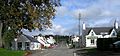 The veelage in 2006
 -
 Urr Pairish Kirk, 2006
 -
 Haugh Brig

.jpg)
References
eedit- ↑ "Dictionary of the Scotland Language: s.v. Haugh". www.dsl.ac.uk. Retrieved 24 Mairch 2015.
- ↑ James, Alan G. (2014). The Brittonic Language in the Old North: A Guide to the Place-Name Evidence (PDF). Volume 2: Guide to the Elements. p. 299. Archived frae the original (PDF) on 11 September 2014.
External links
eedit| Wikimedia Commons haes media relatit tae Haugh of Urr. |
- Owerview of the veelage http://www.scottish-places.info/towns/townfirst3245.html
- Urr pairish kirk https://web.archive.org/web/20070627091830/http://www.dlbteparishch.f9.co.uk/page15.html
- Pairish information http://www.genuki.org.uk/big/sct/KKD/Urr/
- Laich o Urr https://web.archive.org/web/20070701083935/http://www.glenlair.org.uk/vale_of_the_urr.asp
- Unpublisht records for the piarish o Urr in Kirkcoubrieshirehttp://donjaggi.net/galloway/index.html
- River Urr http://www.glenlair.org.uk/river_urr.asp
- Motte o Urr http://www.scottish-places.info/features/featurefirst8406.html
- Motte o Urr https://web.archive.org/web/20070928195711/http://thereformation.info/motte.htm
- Buittle Castle http://www.rcahms.gov.uk/pls/portal/newcanmore.details_gis?inumlink=65002[deid airtin]
| This Places o Scotland airticle is a stub. Ye can help Wikipaedia bi expandin it. |