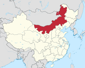
Inner Mongolie
Inner Mongolie (Mongolie: s ![]() , Öbür Monggol an c Өвөр Монгол, Övör Mongol; Cheenese: 内蒙古; pinyin: Nèi Měnggǔ, but offeecially romanizit tae Nei Mongol) is an autonomous region o the Fowkrepublic o Cheenae, located in the northren region o the kintra. Inner Mongolie shares an internaitional border wi the kintras o Mongolie an the Roushie Federation. Its caipital is Hohhot an the lairgest ceety is Baotou.
, Öbür Monggol an c Өвөр Монгол, Övör Mongol; Cheenese: 内蒙古; pinyin: Nèi Měnggǔ, but offeecially romanizit tae Nei Mongol) is an autonomous region o the Fowkrepublic o Cheenae, located in the northren region o the kintra. Inner Mongolie shares an internaitional border wi the kintras o Mongolie an the Roushie Federation. Its caipital is Hohhot an the lairgest ceety is Baotou.
Inner Mongolie Autonomous Region Nei Mongol Autonomous Region 内蒙古自治区 | |
|---|---|
| Name transcription(s) | |
| • Cheenese | 内蒙古自治区 (Nèi Měnggǔ Zìzhìqū) |
| • Abbreviation | 内蒙 or 内蒙古[1] (pinyin: Nèi Měng or Nèi Měnggǔ) |
| Mongolie transcription(s) | |
•  , , | Öbür mongγol-un öbertegen zasaqu orun[2] |
 Map shawin the location o Inner Mongolie Autonomous Region Nei Mongol Autonomous Region | |
| Named for | Frae the Mongolie öbür monggol, whaur öbür means the front, sunny side o natural barrier (a muntain, muntain range, lake or desert etc..). |
| Caipital | Hohhot |
| Lairgest ceety | Baotou |
| Divisions | 12 prefecturs, 101 coonties, 1425 tounships |
| Govrenment | |
| • Secretar | Hu Chunhua |
| • Govrenor | Bagatur |
| Area | |
| • Total | 1183000 km2 (457,000 sq mi) |
| Area rank | 3rd |
| Population (2010) | |
| • Total | 24,706,321[3] |
| • Rank | 23rd |
| • Density rank | 28t |
| Demographics | |
| • Ethnic composeetion | Han - 79% Mongols - 17% Manchu - 2% Hui - 0.9% Daur - 0.3% |
| ISO 3166 code | CN-15 |
| GDP (2011) | CNY 1.40 trillion US$ 218.75 billion (15t) |
| • per capita | CNY 56,666 US$ 8,854 (6t) |
| HDI (2008) | 0.803 (high) (13t) |
| Website | http://www.nmg.gov.cn (Simplifeed Cheenese) |
Inner Mongolie Autonomous Region wis established in 1947 on the aurie o umwhile Republic o Cheenae provinces o Suiyuan, Chahar, Rehe, Liaopeh an Hsingan. It is the third-lairgest subdiveesion o Cheenae spannin aboot 1,200,000 km² (463,000 sq mi) or 12% o Cheenae's total land aurie. It haes a population o aboot 24 million as o 2004. The majority o the population in the region are Han Cheenese, wi a substantial Mongol minority. The offeecial leids are Cheenese an Mongolie, the latter written in the Mongolie script, as opposed tae the Mongolie Cyrillic alphabet uised in the state o Mongolie.
Name
eeditIn Cheenese, the region is kent as "Inner Mongolie", whaur the terms o "Inner/Ooter" are derivit frae Manchu dorgi/tulergi (cf. Mongolie dotugadu/gadagadu). Inner Mongolie is destinct frae Ooter Mongolie, which wis a term uised bi the Republic o Cheenae an previous govrenments tae refer tae wha is nou the independent state o Mongolie plus the Republic o Tuva in Roushie. In Mongolie, the region wis cried Dotugadu monggol durin Qing rule an wis renamit intae Öbür Monggol in 1947, öbür meanin the soothren side o a muntain, while the Chinese term nei menggu wis retained. Some Mongols uise the name "Soothren Mongolie" in Scots as well.[4]
Admeenistrative diveesions
eeditInner Mongolie is dividit intae 12 prefectur-level diveesions.
| Map | # | Conventional[5] | Admeenistrative Seat | Hanzi Hanyu Pinyin |
Mongolie (Transcription frae Mongolie) |
Population (2010) | |
|---|---|---|---|---|---|---|---|
| — Prefectur-level ceety — | |||||||
| 2 | Bayannur | Linhe Destrict | 巴彦淖尔市 Bāyànnào'ěr Shì |
(bayannaɣur qota) |
1,669,915 | ||
| 3 | Wuhai | Haibowan Destrict | 乌海市 Wūhǎi Shì |
(üqai qota) |
532,902 | ||
| 4 | Ordos | Dongsheng Destrict | 鄂尔多斯市 È'ěrduōsī Shì |
(ordus qota) |
1,940,653 | ||
| 5 | Baotou | Kundulun Destrict | 包头市 Bāotóu Shì |
(buɣat qota) |
2,650,364 | ||
| 6 | Hohhot | Huimin Destrict | 呼和浩特市 Hūhéhàotè Shì |
(kökeqota) |
2,866,615 | ||
| 7 | Ulanqab | Jining Destrict | 乌兰察布市 Wūlánchábù Shì |
(ulaɣančab qota) |
2,143,590 | ||
| 9 | Chifeng | Hongshan Destrict | 赤峰市 Chìfēng Shì |
(ulaɣanqad qota) |
4,341,245 | ||
| 10 | Tongliao | Horqin Destrict | 通辽市 Tōngliáo Shì |
(töngliyao qota) |
3,139,153 | ||
| 12 | Hulunbuir | Hailar Destrict | 呼伦贝尔市 Hūlúnbèi'ěr Shì |
(kölün-buyir qota) |
2,549,278 | ||
| — League — | |||||||
| 1 | Alxa League | Alxa Left Banner | 阿拉善盟 Ālāshàn Méng |
(alašan ayimaɣ) |
231,334 | ||
| 8 | Xilingol League | Xilinhot | 锡林郭勒盟 Xīlínguōlè Méng |
(sili-yin ɣoul ayimaɣ) |
1,028,022 | ||
| 11 | Hinggan League | Ulanhot | 兴安盟 Xīng'ān Méng |
(hingɣan ayimaɣ) |
1,613,250 | ||
See an aw
eeditNotes an references
eedit- ↑ 内蒙古自治区区情
- ↑ The Cyrillic spellin, as uised in Mongolie, wad be Өвөр Монголын Өөртөө Засах Орон (Övör Mongolyn Öörtöö Zasakh Oron).
- ↑ "Communiqué of the National Bureau of Statistics of People's Republic of China on Major Figures of the 2010 Population Census". National Bureau of Statistics of China. Archived frae the original on 27 Julie 2013. Retrieved 9 Mairch 2012.
- ↑ Huhbator Borjigin. 2004. The history and political character of the name of 'Nei Menggu' (Inner Mongolia). Inner Asia 6: 61-80.
- ↑ Zhōngguó dìmínglù 中国地名录 (Beijing, Zhōngguó dìtú chūbǎnshè 中国地图出版社 1997); ISBN 7-5031-1718-4.
Freemit airtins
eedit| Wikimedia Commons haes media relatit tae Inner Mongolia. |
- Inner Mongolie Govrenment wabsteid
- Mongolian edition Archived 2012-03-08 at the Wayback Machine
- Travel guide tae Inner Mongolie frae Wikivoyage