Blackburn
Blackburn (![]() pronounced /ˈblækbɜrn/) (help·info)) is a lairge toun in Lancashire, Ingland. It lees tae the north o the Wast Pennine Muirs on the soothren edge o the Ribble Valley, 9 mile (14 km) east o the ceety o Preston, 27 mile (43 km) north-northwast o the ceety o Manchester,[2] an 13 mile (21 km) north o the border wi Greater Manchester. Blackburn is bundit tae the sooth bi Darwen, wi whilk it forms the unitary authority aurie o Blackburn wi Darwen, Blackburn bein the admeenistrative centre. At the time o the UK Govrenment's 2001 census, Blackburn haed a population o 105,085,[1] whilst the wider burgh o Blackburn wi Darwen haed a population o 140,700.[3]
pronounced /ˈblækbɜrn/) (help·info)) is a lairge toun in Lancashire, Ingland. It lees tae the north o the Wast Pennine Muirs on the soothren edge o the Ribble Valley, 9 mile (14 km) east o the ceety o Preston, 27 mile (43 km) north-northwast o the ceety o Manchester,[2] an 13 mile (21 km) north o the border wi Greater Manchester. Blackburn is bundit tae the sooth bi Darwen, wi whilk it forms the unitary authority aurie o Blackburn wi Darwen, Blackburn bein the admeenistrative centre. At the time o the UK Govrenment's 2001 census, Blackburn haed a population o 105,085,[1] whilst the wider burgh o Blackburn wi Darwen haed a population o 140,700.[3]
| Blackburn | |
|---|---|
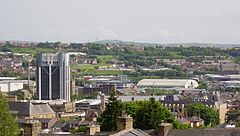
 View sooth–sootheast athort central Blackburn | |
Location within Lancashire | |
| Population | 105,085 [1] |
| • Density | 11,114/sq mi (4,291/km2)[1] |
| OS grid reference | SD685277 |
| • Lunnon | 184 mi (296 km) SSE |
| Unitar authority | |
| Ceremonial coonty | |
| Region | |
| Kintra | Ingland |
| Sovereign state | Unitit Kinrick |
| Post toun | BLACKBURN |
| Postcode destrict | BB1 – BB2 |
| Diallin code | 01254 |
| Police | Lancashire |
| Fire | Lancashire |
| Ambulance | North Wast |
| EU Pairlament | North Wast Ingland |
| UK Pairlament | |
Twin touns
eedit- Péronne, Somme, Fraunce
- Altena, Germany
References
eeditNotes
eedit- ↑ a b c "KS01 Usual resident population: Census 2001, Key Statistics for urban areas". National Statistics. Office for National Statistics. Archived frae the original on 21 Apryle 2007. Retrieved 9 Julie 2008.
- ↑ "Authorities: AGMA Policy and Research Unit". Association of Greater Manchester Authorities. Archived frae the original on 18 October 2015. Retrieved 11 Mey 2010.
- ↑ Census 2001: Blackburn with Darwen Local Authority, Office for National Statistics. Retrieved on 28 March 2008.
Freemit airtins
eedit| Wikimedia Commons haes media relatit tae Blackburn. |
- Blackburn with Darwen Council Archived 2012-02-08 at the Wayback Machine, the wabsteid o Blackburn wi Darwen Borough Cooncil.
- www.cottontown.org, a wabsteid documentin the history o Blackburn wi Darwen as influencit bi the development o the cotton tred.
- Lancashire Telegraph, the daily wittins blad based in Blackburn.
| This Ingland-relatit airticle is a stub. Ye can help Wikipaedia bi expandin it. |
| This toun-relatit airticle is a stub. Ye can help Wikipaedia bi expandin it. |
