Amapá
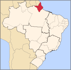
Amapá (Portuguese pronunciation: [amaˈpa][2]) is ane o the states o Brazil, locatit in the extreme north, borderin French Guiana an Suriname tae the north. Tae the east is the Atlantic Ocean, an tae the sooth an wast is the Brazilian state o Pará. The estuary o the River Oiapoque, ance considered the northmaist point o Brazil, is at the extreme north o the Brazilian coast. The dominant featur o the region—90 percent o the total aurie—is the Amazon Rainforest. Unsplored forests occupee 70 percent o its territory. The state's caipital an lairgest ceety Macapá can anerlie be reached bi boat or airplane.
State o Amapá | |
|---|---|
 Location o State o Amapá in Brazil | |
| Coordinates: 1°23′N 51°49′W / 1.383°N 51.817°W | |
| Kintra | |
| Caipital an Lairgest Ceety | Macapá |
| Govrenment | |
| • Govrenor | Camilo Góes Capiberibe |
| • Vice Govrenor | Dora Nascimento de Souza |
| Area | |
| • Total | 142814.585 km2 (55,141.020 sq mi) |
| Area rank | 18t |
| Population (2010 census)[1] | |
| • Total | 668,689 |
| • Rank | 26t |
| • Density | 4.7/km2 (12/sq mi) |
| • Density rank | 24t |
| Demonym(s) | Amapaense |
| GDP | |
| • Year | 2006 estimate |
| • Total | R$ 5,260,000,000 (25t) |
| • Per caipita | R$ 8,543 (14t) |
| HDI | |
| • Year | 2005 |
| • Category | 0.780 – medium (12t) |
| Time zone | UTC-3 (BRT) |
| Postal Code | 68900-000 to 68999-000 |
| ISO 3166 code | BR-AP |
References
eedit- ↑ Censo 2010: população do Brasil é de 190.732.694 pessoas
- ↑ In Brazilian Portuguese. The European Portuguese pronunciation is [ɐmɐˈpa].

