Niigata (ceety)
Niigata (新潟市 Niigata-shi) is the caipital an the maist populous ceety o Niigata Prefectur, Japan. It lies on the northwast coast o Honshū, the lairgest island o Japan, an faces the Sea o Japan an Sado Island.
Niigata 新潟市 | |
|---|---|
| Ceety o Niigata[1] | |
 Frae tap left: NEXT21, Bandai Brig, Toki Messe, Niigata Stadium, Central Niigata an Shinano River in the nicht, Rainbow Touer | |
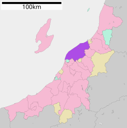
 Location of Niigata in Niigata Prefectur | |
| Coordinates: 37°54′58″N 139°2′11″E / 37.91611°N 139.03639°ECoordinates: 37°54′58″N 139°2′11″E / 37.91611°N 139.03639°E | |
| Kintra | Japan |
| Region | Chūbu (Kōshin'etsu) (Hokuriku) |
| Prefectur | Niigata Prefectur |
| Govrenment | |
| • Mayor | Akira Shinoda |
| Area | |
| • Total | 726.09 km2 (280.34 sq mi) |
| Population (Januar 31, 2012) | |
| • Total | 804,193 |
| • Density | 1107.57/km2 (2,868.6/sq mi) |
| Symbols | |
| • Tree | Willae |
| • Flouer | Tulip |
| Time zone | UTC+9 (Japan Staundart Time) |
| City Hall Address | 1-602-1 Gakkōchō-dōri, Chūō-ku, Niigata-shi, Niigata-ken 951-8550 |
| Website | www |
Wi a lang history as a port toun, Niigata became a free port follaein the Meiji Restoration. Niigata's ceety govrenment wis established in 1889. Mergers wi nearbi municipalities in 2005 alloued the ceety's population tae jump tae 810,000. The annexation o the surroonding aurie haes an aa gien the ceety the greatest rice paddy field acreage in Japan. On 1 Aprile 2007, it became the first govrenment-designatit ceety on the Japan Sea coast o Honshū.
History
eeditMergers
eedit- On 1 Aprile 1889 - the veelage o Sekiya wis amalgamatit intae the toun o Niigata.
- On 1 Aprile 1914 - The toun o Nuttari frae Nakakanbara Destrict wis amalgamatit intae the ceety o Niigata.
- On 1 Juin 1943 - The veelage o Ohgata frae Nakakanbara Destrict wis amalgamatit intae the ceety o Niigata.
- On 8 December 1943 - The veelages o Ishiyama an Toyano frae Nakakanbara Destrict wur amalgamatit intae the ceety o Niigata.
- On 5 Aprile 1954 - The veelage o Matsugasakihama frae Kitakanbara Destrict wis amalgamatit intae the ceety o Niigata.
- On 1 November 1954 - The veelages o Nigorikawa, Minamihama frae Kitakanbara Destrict an the veelage o Sakaiwa frae Nishikanbara Destrict wur amalgamatit intae the ceety o Niigata.
- On 3 Mey 1957 - The veelages o Ryokawa, Sonoki an Oheyama frae Nakakanbara Destrict wur amalgamatit intae the ceety o Niigata.
- On 11 Januar 1960 - The toun o Uchino frae Nishikanbara Destrict wis amalgamatit intae the ceety o Niigata.
- On 1 Juin 1961 - The veelages o Nakanokoya an Akatsuka frae Nishikanbara Destrict wur amalgamatit intae the ceety o Niigata.
- On 1 Januar 2001 - The toun o Kurosaki frae Nishikanbara Destrict wis amalgamatit intae the ceety o Niigata.
- On 12 Mairch 2005 - The ceety o Niitsu, Shirone an Toyosaka, the touns o Kameda, Kosudo an Yokogoshi frae Nakakanbara Destrict an the toun o Nishikawa an the veelages o Ajikata, Iwamuro, Katahigashi, Nakanokuchi an Tsukigata frae Nishikanbara Destrict wur aw merged intae the ceety o Niigata.
- On 10 October 2005 - The toun o Maki frae Nishikanbara Destrict merged intae the ceety o Niigata.
Sister ceeties
eeditNiigata maintains sister ceety ties wi sax ceeties:
- Galveston, Unitit States (1965)
- Khabarovsk, Roushie (1965)
- Harbin, Cheenae (1979)
- Vladivostok, Roushie (1991)
- Birobidzhan, Roushie (Ance a sister ceety o Toyosaka, Niigata assumed the sister ceety honors in 2005)
- Nantes, Fraunce (2009, shiftit frae friendship ceety syne 1999)
In addition, special exchynge agreements hae been set up wi:
Sports
eedit- J. League (Fitbaa/Soccer)
- Albirex Niigata play at Big Swan Stadium
- Bj league (Basketbaa)
- Niigata Albirex BB play at Toki Messe
References
eedit| Wikimedia Commons haes media relatit tae Niigata (ceety). |
