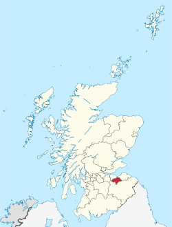
Midlowden
(Reguidit frae Midlothian)
Midlowden (Inglis: Midlothian, Scots Gaelic: Meadhan Lodainn) is ane o the 32 cooncil areas o Scotland, an a lieutenancie area anaw. It haes mairches wi East Lowden, Ceitie o Edinburgh an The Mairches cooncil areas.
| |
|---|---|
 | |
| Coordinates: 55°53′39″N 3°04′07″W / 55.89417°N 3.06861°WCoordinates: 55°53′39″N 3°04′07″W / 55.89417°N 3.06861°W | |
| Admin HQ | Dawkeith |
| Govrenment | |
| • Bodi | Midlowden Cooncil |
| • Control | Labour minority (cooncil NOC) |
| • MPs |
|
| • MSPs |
|
| Area | |
| • Total | 353.7 km2 (136.6 sq mi) |
| Area rank | Ranked 21st |
| Population (mid-2016 est.) | |
| • Total | 88,600 |
| • Rank | Rankit 26th |
| • Density | 250/km2 (600/sq mi) |
| ONS code | S12000019 |
| ISO 3166 code | GB-MLN |
| Website | www |
The Midlowden cooncil area wis shapit in 1996, unner the Local Govrenment etc. (Scotland) Act 1994, wi the boonds o the Midlowden destrik o the Lowden region. The destrik haed been shapit in 1975, unner the Local Govrenment (Scotland) Act 1973.
The cooncil area's heidsteid is the toun o Dalkeith.
Touns an veelages
eedit- Auchendinny
- Bilston
- Bonnyrigg
- Borthwick
- Carrington
- Dalkeith
- Danderhall
- Easthouses
- Edgeheid
- Falae
- Fushiebrig
- Gorebrig
- Gowkshill
- Hillend
- Howgate
- Lasswade
- Leadburn
- Loanheid
- Mayfeild
- Millerhill
- Milton Brig
- Newbattil
- Newtongrange
- Nyn Mile Burn
- North Middilton
- Pathheid
- Penicuik
- Rosewell
- Roslin
- Shawfair
- Silverburn
- Temple
Steids o interest
eedit- Arniston Houss
- Borthwick Castil
- Castillaw Fort
- Crichton Castil
- Dalhousie Castil
- Dalkeith Pailass
- Flotterstane
- Hawthornden Castil
- Loanheid Memorial Pairk
- Mavisbank Houss
- Melville Castil
- Newbattil Abbey
- Pentland Hills
- Roslin Castil
- Roslin Glen Kintra Pairk
- Rosslyn Chaipil
- Tyne-Esk Walk
- Vogrie Kintra Pairk
- Wallace's Cove
References
eedit
| This Scotland-relatit airticle is a stub. Ye can help Wikipaedia bi expandin it. |
| This Places o Scotland airticle is a stub. Ye can help Wikipaedia bi expandin it. |