Entre Ríos Province
Entre Ríos (Spaingie pronunciation: [ˈentɾe ˈri.os], Atween Rivers) is a central province o Argentinae, locatit in the Mesopotamie region. It borders the provinces o Buenos Aires (sooth), Corrientes (north) an Santa Fe (wast), an Uruguay in the east.
Entre Ríos | |
|---|---|
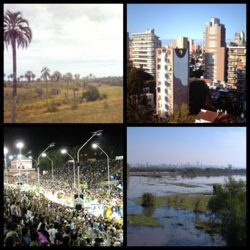
 Clockwise frae top: El Palmar National Park, Paraná, Carnival in Gualeguaychú, Paraná Delta wi Rosario in the backgrund. | |
 Location o Entre Ríos athin Argentinae | |
| Kintra | Argentinae |
| Caipital | Paraná |
| Depairtments | 17 |
| Municipalities an buird o govrenors | 266 |
| Govrenment | |
| • Govrenor | Gustavo Bordet (PJ) |
| • Deputies | 9 |
| • Senators | 3 |
| Area | |
| • Total | 78781 km2 (30,418 sq mi) |
| Population (2010[1]) | |
| • Total | 1,235,994 |
| • Rank | 7t |
| • Density | 16/km2 (41/sq mi) |
| Demonym(s) | entrerriano |
| Time zone | UTC−3 (ART) |
| ISO 3166 code | AR-E |
| Website | www |
Its caipital is Paraná (250,000 indwallers), which lees on the Paraná River, opposite the ceety o Santa Fe.
Thegither wi Córdoba an Santa Fe, syne 1999, the province is pairt o the economic-poleetical association kent as the Center Region.
History
eeditThe first indwallers o the aurie that is nou Entre Ríos wur the Guaraní, Charrúa an Chaná, who each occupeed separate pairts o the region. Spaniards entered in 1520, whan Rodríguez Serrano ventured up the Uruguay River searchin for the Paceefic Ocean.
The first permanent Spaingie dounset wis erected in the current La Paz Department at the end o the 16t century. As governor of Asunción first an then of Buenos Aires, Hernandarias conducted expeditions tae Entre Ríos unexplored lands. Juan de Garay, efter founding Santa Fe, explored this aurie, which he cried la otra banda ("the other bank").
Housomeivver, the region remained entirely indigenous an uninhabitit bi Europeans till a group o colonists frae neebourin Santa Fe Province settled on the Bajada del Paraná in the late seiventeent century, nou the steid o the provincial caipital. At the same time touns appear, which we nou ken as Nogoyá, Victoria, Gualeguay, Gualeguaychú, Concepción del Uruguay an Concordia.
Tomás de Rocamora further splorit the aurie in 1783 unner the threat o a Portuguese invasion frae Brazil, an gae offeecial status tae mony o the abuin mentioned touns. He wis the first tae refer tae the region as Entre Ríos an aw. At this stage, European dounset wis minimal, tho durin the Mey Revolution, the few colonists in the ceeties alang the Paraná shore supportit Manuel Belgrano an his airmy on his wey tae Paraguay.
On 29 September 1820, the leader (caudillo) Francisco Ramírez declared the territory an autonomous entity, the Republic o Entre Ríos. This lasted till his assassination on Julie 10 o the next year.
In 1853, in a meetin o aw the provinces except Buenos Aires, Paraná wis elected as the caipital o the Argentine Confederation, an the leader (caudillo) Urquiza as its first preses. The provincial caipital wis muivit tae Concepción del Uruguay. Defeatit, Urquiza wis electit govrenor o the province a few years later, while Domingo Faustino Sarmiento became preses, but he wis assassinatit afore feenishin his mandate.
Urquiza encouragit immigration throu "colonization contracts", setting up mony agricultural colonies wi European (mainly Volga Germans, Roushies (includin Roushie Jews an Poles), Italians, Swiss an French) settlers. Accordin tae data o the 1903 census, o the 425,373 indwallers o the province, 153,067 wur immigrants.
Economy
eeditEntre Rios' economy is the saxt lairgest in Argentinae. Its ootput in 2006 wis estimatit at US$7.8 billion (which shall be aroond US$12 billion in 2011, accordin tae Argentinae's economical growin), or, US$6,710 per caipita in 2006 (aboot a fowert less nor the naitional average),[2] awtho it shall be aroond US$9,600 in 2011.
Its economy haes lang been mair agricultural than the median in Argentinae, comprisin aboot 15% o ootput. Entre Rios' agricultural products include rice (60% o the naitional production), soybeans, wheat, maize, an citrus o which it is the seicont biggest producer, an exportin 16% o the production mainly tae Europe. Livestock production focuses on cattle (4.5 million heid), an in sheep production in a decreasin proportion, coverin 60,000 km². The dairy industrie, currently in expansion, produces amaist 250 thoosan tons per year o dairy products.
O the naitional production o chickens an eggs, Entre Ríos contributes 37% o the first an 25% percent o the seicont. Anither emergin production is honey an its derivatives, mainly for export.
Manufacturin haes a sizable presence in Entre Rios, makkin up anither 15% o ootput. Its industries are maistly linkit tae agricultur, as in fuid an drinks industry an flouer an rice mills. Ither industries include timmer-firth, chemical, metallurgie, an machinery.
Geografie an climate
eeditAs pairt o the Mesopotamic region, the laund is amaist completely flat, wi hills some 100 metres in hicht. Thare are twa main seestems o law hills, cried lomadas or cuchillas: the Cuchilla de Montiel (wast) an the Cuchilla Grande (east), which are separatit bi the Gualeguay River.
The name o the province means "atween rivers". Entre Ríos is limitit an traversed bi mony rivers an streams: the Paraná River an its delta tae the wast an sooth; the Uruguay River an the Mocoretá River tae the east; an the Guayquiraró River tae the north.
The wather variates frae subtropical in the north tae temperate towards the Pampas. The annual rainfaw is aboot 1150 mm in average, an occasional pampero an ither local winds bring storms tae the aurie.
Twa naitional pairks are locatit athin the province: El Palmar Naitional Pairk an Predelta Naitional Pairk. Thare are hot springs in several locations an aw, especially alang the basin o the Uruguay River, locatit in ceeties lik Federación, Villa Elisa, Colón, etc.
Poleetical diveesion
eedit(Spaingie: departamentos singular departamento).
The province is dividit in 17 depairtments Depairtment (Caipital)
- Colón (Colón)
- Concordia (Concordia)
- Diamante (Diamante)
- Federación (Federación)
- Federal (Federal)
- Gualeguay (Gualeguay)
- Gualeguaychú (Gualeguaychú)
- Islas del Ibicuy (Villa Paranacito)
- La Paz (La Paz)
- Nogoyá (Nogoyá)
- Paraná (Paraná)
- San José de Feliciano (San José de Feliciano)
- San Salvador (San Salvador)
- Tala (Rosario del Tala)
- Uruguay (Concepción del Uruguay)
- Victoria (Victoria)
- Villaguay (Villaguay)
References
eedit- ↑ [1]
- ↑ "I.A.D.E.R". Archived frae the original on 21 Februar 2013. Retrieved 8 Mairch 2013.
Freemit airtins
eedit| Wikimedia Commons haes media relatit tae Entre_Ríos. |
- Offeecial Steid (Spainyie)

