Cummertrees
Cummertrees is a coastal veelage in ceevil pairish in Annandale in the historical coonty o Dumfriesshire in Dumfries an Gallowa, Scotland. It lies aboot ae mile inland, on the Pow Watter, 12 mile fae Dumfries and 3 mile fae Annan.[1]
| Cummertrees | |
|---|---|
 Seaside-style haliday hooses in Cummertrees's Queensberry Terrace | |
 Cummertrees Location within Dumfries an Gallowa | |
| OS grid reference | NY141664 |
| Cooncil area | |
| Lieutenancy area | |
| Kintra | Scotland |
| Sovereign state | Unitit Kinrick |
| Post toun | ANNAN |
| Postcode destrict | DG12 |
| Police | Scots |
| Fire | Scots |
| Ambulance | Scots |
| EU Pairlament | Scotland |
| UK Pairlament | |
| Scots Pairlament | |
Etymology
eeditCummertrees, recordit as Cumbertres in 1204 an 1207, is likely o Cumbric oreegin.[2] The seicont element represents *tres "sturt, habbleshew, shirrmineer", cognate wi Welsh tres an Scots Gaelic treas.[2][3][4] The first element is *cümber, cömber "confluence".[2][4][5] The first element is cümber, cömber "infaw". Andrew Breeze propones the meanin "infaw o turbulent watter".[2] Alan James suggests that *tres micht hae been the name o a burn.[3]
Houiver, James notes, that the first element micht represent *cömbröɣ, that occurs in the name Cumbria.[6][7]
History
eeditCummertrees is a landwart, maistly residential, veelage, the pairish includes Powfuit and Trailtrow, and is boondit bi St Mungo and Hoddom, Annan, the Solway Firth, an Rivvel and Dalton. A public haw wis upsetten at Cummertrees in 1893.[1] The River Annan is at the northren boond. It haes a wide aurie o level saund soopit bi the Solway '(tidal) bore' that can muive at aboot 10 mile an oor an can aften be heard ootthrou the pairish. The coastal laund is law an saundy, an featurs in Sir Walter Scott's novelle Redgauntlet. The grund rises a bit inland, tae 350 fit on Repentence Hill.[1]
The local geology is mainly Devonian, wi auld limestane warks at Kelhead an some sandstane quarrels.[1]
In a field cried Bruce's Acres, at Broom Ferm, King Robert the Bruce focht an lost a skirmish again the English.
Cummertrees Pairish includes some namely biggins: Hoddam Castle, Kinmount Hoose, and Murraythwaite. Historical, the main laird haes been the Marquess o Queensberry. A nearby caravan pairk haes been name't in his memory. The kirk wis foondit bi Robert the Bruce an haes been muckle rebuilt an eikit.[1] The Douglas Faimily Mausoleum at Cummertrees Pairish Kirk is the tradeetional buirial place o the Marquesses o Queensberry. Thare is a preevat faimly buirial grund an aw datin fae the mid 19t century for the Queensberry faimily on Gooley Hill withing the policies o Kinmount Hoose.[1] Archived 2019-03-27 at the Wayback Machine
Kinmount Hoose
eeditKinmount Hoose wis the seat o the Marquesses o Queensberry, descrived by Groome in 1903 as
- a beautiful edifice, built in the early part of the 19th century at a cost of £40,000, and surrounded by fine pleasure grounds.[8]
Transport
eeditCummertrees railwey station wis appent in 1848 bi the Glasgow, Dumfries and Carlisle Railway that syne becam pair o the Glasgow and South Western Railway. It wis closed bi the British Railways Board in 1955. This fine station biggin survives a preevat residence.
Gailerie
eedit-
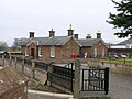 The auld Cummertrees railwey station.
 -
 The pairish kirk and lykegait.
 -
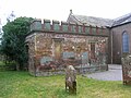 The Douglas Faimily Mausoleum at Cummertrees Pairish Kirk, tradeetional buirial place of the Marquesses o Queensberry.
 -
 Haliday apairtments at Agnes Hill.


Namely residenters
eedit- Leddy Florence Dixie (1855-1905) - Scots writer, war correspondent, feminist. Dochter o the 8t Marquess o Queensberry. Guidwife o Sir Alexander Beaumont Churchill Dixie, 11t Baronet (1851-1924)
- Laird Francis Douglas (1847-1865) - novice Breetish muntaineer. Efter skarin in the first ascent o the Matterhorn on the mairch atween Italy an Swisserland, he dee'd in a faw on the wey doun fae the summit, aged juist 18.
- Steve Ovett (born 1955) - English track athlete, bade at Kinmount Hoose fae 1988 tae 1998.
References
eedit- ↑ a b c d e Groome, Francis H. Ordnance Gazetteer of Scotland: A Survey of Scottish Topography, Statistical, Biographical, and Historical. II. London: William Mackenzie. p. 327.
- ↑ a b c d Breeze, Andrew (2005). "Brittonic Place-Names from South-West Scotland, Part 6: Cummertrees, Beltrees, Trevercarcou" (PDF). Transactions and Journal of Proceedings of the Dumfriesshire and Galloway Natural History and Antiquarian Society. Third Series. LXXIX: 91. Archived frae the original (PDF) on 31 August 2014.
- ↑ a b James, Alan G. (2014). The Brittonic Language in the Old North: A Guide to the Place-Name Evidence (PDF). Volume 2: Guide to the Elements. p. 367. Archived frae the original (PDF) on 11 September 2014.
- ↑ a b Watson, William J. (1925). "The Celts (British and Gael) in Dumfriesshire and Galloway" (PDF). Transactions and Journal of Proceedings of the Dumfriesshire and Galloway Natural History and Antiquarian Society. Third Series. XI: 147. Archived frae the original (PDF) on 31 August 2014.
- ↑ James, Alan G. (2014). The Brittonic Language in the Old North: A Guide to the Place-Name Evidence (PDF). Volume 2: Guide to the Elements. p. 109. Archived frae the original (PDF) on 11 September 2014.
- ↑ James, Alan G. (2014). The Brittonic Language in the Old North: A Guide to the Place-Name Evidence (PDF). Volume 2: Guide to the Elements. p. 110. Archived frae the original (PDF) on 11 September 2014.
- ↑ James, Alan G. (2013). "P-Celtic in Southern Scotland and Cumbria: A review of the place-name evidence for possible Pictish phonology" (PDF). The Journal of Scottish Name Studies: 45. Archived frae the original (PDF) on 2 Apryle 2015.
- ↑ Groome, Page 964
External links
eedit| Wikimedia Commons haes media relatit tae Cummertrees. |
| This Places o Scotland airticle is a stub. Ye can help Wikipaedia bi expandin it. |