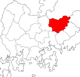
Miryang
Miryang, aften spelt Milyang, is a ceety in Gyeongsangnam-do Province, Sooth Korea. Neebourin ceeties include Changnyeong tae the wast, Cheongdo tae the north, Ulsan tae the east, an Yangsan, Gimhae, an Changwon tae the sooth. The ceety bird is the Korean magpie, the ceety tree is the pine, an the ceety flouer is the ryal azalea.
Miryang 밀양 | |
|---|---|
| Korean transcription(s) | |
| • Hangul | 밀양시 |
| • Hanja | 密陽市 |
| • Revised Romanization | Miryang-si |
| • McCune-Reischauer | Miryang-si |
 | |
| Kintra | |
| Region | Yeongnam |
| Admeenistrative divisions | 2 eup, 9 myeon, 5 dong |
| Area | |
| • Total | 799.03 km2 (308.51 sq mi) |
| Population (2006) | |
| • Total | 112,602 |
| • Density | 140.9/km2 (365/sq mi) |
| • Dialect | Gyeongsang |
The recordit history o Miryang begins in the Samhan period, when it wis kent as Mirimidongguk. Due tae its strategic location near the Nakdong River, Miryang played an important role frae the Silla period forrit. It servit as an important station on the Great Yeongnam Road durin the later Joseon Dynasty, an in the 20t century it became a station on the Gyeongbu Line railwey that connects Busan tae Seoul. Miryang remains a key stop alang that line, an is nou the anerlie ceety atween Busan an Daegu servit bi KTX express trains.
Miryang is kent aroond Korea for the Miryang arirang an for the view frae the Yeongnamnu pavilion, subject o numerous poems frae the Joseon Dynasty. Other notit landmarks include Eoreumgol an the temple o Pyochungsa. Famous fowk frae Miryang include 15t-century Neo-Confucian scholar Kim Jong-jik an 16t-century warrior-monk Songun Yu Jeong. The ceety govrenment wirks actively tae maintain the memory o these figurs, an o ither local cultural featurs such as the tale o Arang.
Notes
eeditReferences
eedit- Lee Hong-jik (이홍직) (1983). 새國史事典 (Sae guksa sajeon, New encyclopedia of Korean history). Seoul: Kyohaksa.
- Miryang City (2005). "밀양시 통계연보 (Miryang-si tonggye yeonbo, Statistical yearbook of Miryang City)". Archived frae the original on 22 Mey 2006. Retrieved 16 September 2006.
- Pak Byeong-ryeon (박병련) ed. (2004). 남명학파와 영남우도의 사림 (Nammyeonghakpa-wa Yeongnamudo-ui sarim, The Nammyeong school and the Sarim of right-hand Yeongnam Province). Seoul: Yemoon Seowon. ISBN 89-7646-190-8.CS1 maint: extra text: authors leet (link)
Freemit airtins
eedit- Ceety govrenment wabsteid Archived 2012-11-09 at the Wayback Machine