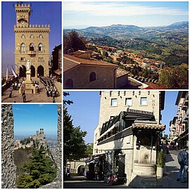
Ceety o San Marino
The Ceety o San Marino, an aa kent simply as San Marino, is the caipital ceety o the Republic o San Marino on the Italian peninsula, near the Adriatic Sea. The ceety haes a population o 4,493. It is on the wastren slopes o San Marino's heichest pynt, Monte Titano.
Ceety o San Marino Città di San Marino | |
|---|---|
castello | |
 A collage o the Ceety o San Marino. | |
 San Marino's location in San Marino | |
| Coordinates: 43°56′4.56″N 12°26′50.28″E / 43.9346000°N 12.4473000°E | |
| Kintra | |
| Foondation | 3 September 301 (traditional date) |
| Govrenment | |
| • Capitano | Alessandro Barulli (syne 2003) |
| Area | |
| • Total | 7.09 km2 (2.74 sq mi) |
| Elevation | 749 m (2,457 ft) |
| Population (2003) | |
| • Total | 4,493 |
| • Density | 633.71/km2 (1,641.3/sq mi) |
| Time zone | UTC+1 (CET) |
| • Summer (DST) | UTC+2 (CEST) |
| Postal code | RSM-47890 |
Geography
eeditAwtho the caipital, maist o the businesses are in Borgo Maggiore. It is the third lairgest ceety in the kintra, efter Dogana an Borgo Maggiore. It borders the San Marino municipalities Acquaviva, Borgo Maggiore, Fiorentino, an Chiesanuova an the Italian municipality San Leo.
Akademio Internacia de la Sciencoj San Marino is centred here.
Heestory
eeditDue tae its being the caipital an previously the ae ceety in San Marino, the heestory o this ceety is almaist the same as the Heestory o San Marino. For more information on that topic, see that airticle.
The ceety wis foondit bi Saunt Marinus an several Christian refugees in the year 301. Frae then on the ceety became a centre o Christian refugees who fled frae Roman persecution. As a result, the ceety acome the auldest republic in Europe, for the republic's territory at that time ae includit the single ceety o San Marino.
The urban hert o the ceety wis protectit bi three touers: the first, Guaita, constructit in the 11t century, wis famous for bein impenetrable, which tae a great extent discouraged attacks on the ceety.
Due tae the Crusades, it wis felt necessar tae big a seicont touer, Cesta (13t century). But the Sanmarinense defensive seestem wis no completit till the construction o a third touer, the Montale (14t century) - the smawest o aw an constructit on the last o the summits o Monte Titano.
Wi the population o the ceety increasin, the territory o the kintra wis extendit bi a few square kilometers. Syne the Sanmarinese policy wis no tae invade or tae uise war tae obtain new territories, it wis bi means o purchases an treaties that San Marino obtained the ither nine castelli which mak up San Marino.
Parishes
eeditThe Ceety o San Marino haes the followin parishes or wards (curazie):
Economy
eeditThe economy o the ceety o San Marino haes always been closely boond tae that o the kintra. Tiil recently, the main economic activities o the locality wur stane extraction an carvin. The day, thare is a mair varied economy, includin tourism, commerce, sale o postage stamps, an a sma agricultural industry, awtho the last is in decay.
Sports
eeditThe ceety o San Marino haes twa fitbaa teams: the S.S. Murata an the S.P. Tre Penne. The ceety haed the Olympic Flame pass throu San Marino durin the run-up tae the 2006 Winter Olympics.
Internaitional relations
eeditTwin touns—Sister ceeties
eeditCeety o San Marino is twinned wi:
References
eeditFreemit airtins
eeditMedia relatit tae San Marino (city) at Wikimedia Commons Coordinates: 43°56′05″N 12°26′50″E / 43.9346°N 12.4473°E
| Wikimedia Commons haes media relatit tae San Marino (city). |


