Santiago Juxtlahuaca
Santiago Juxtlahuaca is a toun an municipality in Oaxaca in sooth-wastren Mexico. It is in the Juxtlahuaca Destrict o the Mixteca Region.
Santiago Juxtlahuaca | |
|---|---|
Municipality an toun | |
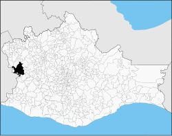
 Location of the municipality in Oaxaca | |
| Kintra | |
| State | Oaxaca |
| Area | |
| • Total | 583.05 km2 (225.12 sq mi) |
| Elevation | 1690 m (5,540 ft) |
| Population (2005) | |
| • Total | 33,401 |
| Time zone | UTC-6 (Central Staundart Time) |
| • Summer (DST) | UTC-5 (Central Daylicht Time) |
Town
eeditThe toun is at a hicht o 1,690 metres abuin sea level. It is ane o the auldest touns in the Mixteca region o Oaxaca, datin back tae the 12t century AD. The first Spainyie visitor wis the Dominican friar Gonzalo Lucero, who passed throu in the year 1536 on a jurney o sploration. Three years later, the monk Benito Hernández persuadit the natives tae muive tae a new location, foondit on 13 September 1542. Atween 1600 an 1633 the toun wis muivit tae its current location in the north o the valley, wi the first streets laid oot in the Spaingie style. The toun wis periodically shaken bi yirdquauks durin the colonial period, destroyin kirks an ither major biggins. The toun wis connectit tae the ootside warld bi a telegraph line in Mairch 1883. A landwart halth centre wis established in Apryle 1938, an in 1944 an airfield wis opened.[1]
Municipality
eeditThe municipality covers a aurie o 583.05 square kilometre (225.12 sq mi). As o 2005, the municipality haed a tot population o 33,401 in 6,165 hoosehaulds. O thir, 20,648 fowk spoke a indigenous leid.[2]
References
eedit- ↑ "SANTIAGO Juxtlahuaca". Enciclopedia de los Municipios de México: ESTADO DE OAXACA. Archived frae the original on 16 Juin 2011. Retrieved 6 Juin 2010.
- ↑ Instituto Nacional de Estadística y Geografía. "Oaxaca. Indicadores seleccionados de la población por municipio, 2005". Retrieved 13 Juin 2010.