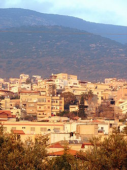
Rameh
Rameh (Arabic: الرامة; Hebrew: רָמָה; also spelled ar-Rame or ar-Rama) is a local cooncil in the North Destrict o Israel. It is entirely populatit bi Arabs, o whom aroond 51% are Christian, 29% Druze, an a further 20% Muslim. The toun is locatit five kilometers east o the ceeties o Shaghur an Karmiel.[1]
Rameh
| |
|---|---|
| Hebrew transcription(s) | |
| • ISO 259 | Ráma |
| • Forby spelt | Rame (offeecial) al-Rama (unoffeecial) |
 | |
| Coordinates: 32°56′21.3″N 35°22′1.61″E / 32.939250°N 35.3671139°ECoordinates: 32°56′21.3″N 35°22′1.61″E / 32.939250°N 35.3671139°E | |
| Destrict | Northren |
| Foondit | 17t Century |
| Govrenment | |
| • Teep | Local cooncil (frae 2005) |
| Area | |
| • Total | 6.118 km2 (2.362 sq mi) |
| Population (2005) | |
| • Total | 7,500 |
| • Density | 1,200/km2 (3,200/sq mi) |
History
eeditEdward Robinson identifees Rameh wi the auncient Ramah o Asher (Joshua 19,29), citin its location an auncient sarcophagi discovered on a hill ootside the veelage as evidence.[2] Rameh wis a major toun durin the rule o the Crusaders.
Accordin tae local tradition, the modren toun o Rameh wis foondit in the 17t century. It wis ane o the lairgest veelages in the Galilee durin the period o Ottoman Empire control. In 1923, Rameh became the first veelage in Palestine tae receive sel-govrenin status grantit bi the Breetish Mandate an haed the lairgest olive orchards in the aurie.[1] It was granted permission to self-govern through a village council.[3] It wis captured bi Haganah forces in 1948, becomin a pairt o Israel, an later achievin local cooncil status in 1954.
See an aw
eeditReferences
eedit- ↑ a b Rame (Israel) Gutterman, Dov. CRW Flags.
- ↑ Robinson, Edward. (1856) Biblical Researches in Palestine, 1838-52 J. Murray: pp.64-65.
- ↑ Survey of Palestine Breetish Mandate o Palestine. Vol. 1, p.132.
