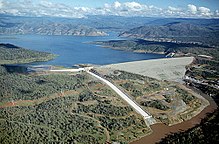
Oroville Dam
yirdfill embankment dam on the Feather River east o the ceety o Oroville, Californie, in the Unitit States
Oroville Dam is a yirdfill embankment dam on the Feather River east o the ceety o Oroville, Californie, in the Unitit States. At 770 feet (235 m) heich, it is the tawest dam in the U.S.[8] an serves mainly for watter supply, hydroelectricity generation an fluid control. The dam impoonds Loch Oroville, the seicont lairgest man-made loch in the state o Californie, capable o storin mair nor 3.5 million acre-feet (4.4 km3)[9]. It is locatit in the Sierra Nevada fithills east o the Sacramento Valley.
| Oroville Dam | |
|---|---|
 | |
| Kintra | United States |
| Location | Oroville, Californie |
| Coordinates | 39°32′20″N 121°29′08″W / 39.53889°N 121.48556°WCoordinates: 39°32′20″N 121°29′08″W / 39.53889°N 121.48556°W[1] |
| Purpose | Watter supply, fluid control, pouer |
| Status | Operational |
| Construction begoud | 1961 |
| Appenin date | May 4, 1968 |
| Awner(s) | Californie Depairtment o Watter Resources |
| Dam an spillweys | |
| Teep o dam | Zoned Earthfill |
| Impoonds | Feather River |
| Hicht (foondation) | 770 ft (235 m)[2] |
| Lenth | 6,920 ft (2,109 m)[2] |
| Dam vollum | 77,619,000 cu yd (59,344,000 m3) |
| Spillwey teep | Service, 8x gate-controlled |
| Spillwey capacity | 150,000 cu ft/s (4,200 m3/s) (service)[3] |
| Reservoir | |
| Creauts | Loch Oroville |
| Tot capacity | 3,537,577 acre⋅ft (4.363537 km3)[4] |
| Inactive capacity | 29,600 acre⋅ft (0.0365 km3)[5] |
| Catchment aurie | 3,607 sq mi (9,340 km2)[4] |
| Surface aurie | 15,805 acre (6,396 ha)[4] |
| Normal elevation | 901 ft (275 m) (spillway crest)[3] |
| Hydraulic heid | 615 ft (187 m)[6] |
| Turbines | 3x conventional 3x pump-generators |
| Instawed capacity | 819 MW[6] |
| Annual generation | 1,490 GWh[7] |
| Wabsteid Oroville Dam | |
Efter hivy rains in Februar 2017, the main spillwey wis damaged an an anticipatit failur o the auxiliary spillwey resultit in the mass evacuation o touns in the river basin.
References
eedit- ↑ "Lake Oroville". Geographic Names Information System. United States Geological Survey. 19 Januar 1981. Retrieved 31 Mairch 2012.
- ↑ a b "Oroville Dam". National Performance of Dams Program. Stanford University. Archived frae the original on 29 Mairch 2020. Retrieved 31 Mairch 2012.
- ↑ a b "Oroville Facilities (FERC Project No. 2100)" (PDF). California Department of Water Resources. Januar 2005. Archived frae the original (PDF) on 25 Mey 2017. Retrieved 13 Februar 2017.
- ↑ a b c "Oroville Dam (ORO)". California Data Exchange Center. California Department of Water Resources. Retrieved 31 Mairch 2012.
- ↑ Ritzema, Randall S.; Newlin, Brad D.; Van Lienden, Brian J. (October 2001). "Appendix H: Infrastructure" (PDF). CALVIN Project. University of California Davis. Archived frae the original (PDF) on 6 November 2017. Retrieved 25 Januar 2014.
- ↑ a b Cite error: Invalid
<ref>tag; no text was provided for refs namedpower - ↑ "California Hydroelectric Statistics & Data". California Energy Commission. Archived frae the original on 28 Januar 2015. Retrieved 24 Januar 2015.
- ↑ "Dam, Hydropower and Reservoir Statistics". United States Society on Dams. Archived frae the original on 25 Mairch 2012. Retrieved 31 Mairch 2012.
- ↑ "Alphabetical List of California Dams (Over 40,000 acre feet)". Civil and Environmental Engineering. University of California Davis. Archived frae the original on 5 Februar 2012. Retrieved 31 Mairch 2012.
