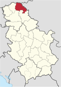
North Banat Destrict
North Banat Destrict (Serbie: Севернобанатски округ, Severnobanatski okrug, Hungarian: Észak-bánsági körzet, Croatie: Sjevernobanatski okrug, Slovak: Severobanátsky okres, Romanie: Districtul Banatul de Nord, Rusyn: Сивернобанатски окрух) is a northren district o Serbie. It lees in the regions o Banat an Bačka, in the autonomous province o Vojvodina. As o the 2011 census, the destrict haes a population of 146,690. The seat o the destrict is Kikinda.
Severnobanatski okrug Севернобанатски округ Észak-bánsági körzet Sjevernobanatski okrug Districtul Banatul de Nord Severobanátsky okres Сивернобанатски окрух | |
|---|---|
 Location o North Banat District in Serbie | |
| Kintra | |
| Caipital | Kikinda |
| Govrenment | |
| • Commissioner | n/a |
| Area | |
| • Total | 2,329 km2 (899 sq mi) |
| Population (2011 census) | |
| • Total | 146,690 |
| • Density | 63.0/km2 (163/sq mi) |
| Municipalities | 6 |
| Settlements | 50 |
| - Ceeties an touns | 7 |
| - Veelages | 43 |


Municipalities
eeditThe North Banat Destrict comprises 6 municipalities an 50 local commonties. The municipalities are:
- Kanjiža (Hungarian: Magyarkanizsa)
- Senta (Hungarian: Zenta)
- Ada (Hungarian: Ada)
- Čoka (Hungarian: Csóka)
- Novi Kneževac
- Kikinda
Note: for municipalities wi Hungarian ethnic majority, the names aregiven in Hungarian an aw.
An interestin fact is that the first three municipalities enleetit (Kanjiža, Senta an Ada) are geografically, in fact, in the Bačka region syne the naitural mairch aetween Banat an Bačka is the river Tisa.
Demografics
eeditThe destrict is ethnically mixed. Its population is componed o (Census 2002):
- Hungarians = 78,551 (47.35%)
- Serbs = 72,242 (43.55%)
- Roma = 3,944 (2.37%)
- Yugoslavs = 3,018 (1.81%)
- Ithers
Leids spoken in the destrict (Census 2002):
Municipalities wi Serb ethnic majority are Kikinda (76.43%) an Novi Kneževac (59.53%), while municipalities wi Hungarian ethnic majority are: Ada (76.64%), Čoka (51.56%), Kanjiža (86.52%), an Senta (80.51%).
As for local commonties, 30 hae Hungarian majority, 19 hae Serb majority, an 1 is ethnically mixed, wi Hungarian relative majority.
Administrative history
eeditIn the 9t century, the aurie wis ruled bi the Bulgarian-Slavic dukes Glad (in the east) and Salan (in the wast), while in the 11t century, the eastren pairt o the aurie wis ruled bi duke Ahtum. Frae 11t tae 16t century, during the admeenistration o the medieval Kinrick o Hungary, the aurie wis dividit atween the Csanadiensis County, Temesiensis County and Torontaliensis County in the east, an Csongradiensis County, Bacsensis County and Bodrogiensis County in the wast. Pairt o the aurie wis an aa locatit within the Cumania region. In 1526-1527, the aurie wis ruled bi the independent Serb ruler, emperor Jovan Nenad, while during Ottoman admeenistration (16t-18t century), it wis dividit atween the Temeşvar Eyalet in the east an the Sanjak of Segedin in the wast.
During Habsburg admeenistration (18t century), the aurie wis dividit atween the Banat of Temeswar in the east an the Military Frontier in the wast. Syne the abolishment o the Theiß-Marosch section o the Military Frontier (in 1751), and abolishment o the Banat of Temeswar (in 1778), the aurie wis dividit atween the Torontal County in the east an the Batsch-Bodrog County in the wast, wi a smaw pairt of it that wis locatit within the Tschongrad County. Much o the aurie wis pairt o the autonomous districts of Velika Kikinda (existit frae 1774 tae 1876 within the Torontal County) in the east and Potisje (existit frae 1751 tae 1848 within the Batsch-Bodrog County) in the wast. In 1850s, the aurie wis dividit atween the Veliki Bečkerek District in the east and Sombor and Novi Sad districts in the wast. Efter 1860, it wis again dividit atween Torontal, Batsch-Bodrog and Tschongrad counties.
During the royal Serb-Croat-Slovene (Yugoslav) admeenistration (1918-1941), the aurie wis initially (frae 1918 tae 1922) dividit atween the Veliki Bečkerek County in the east an the Novi Sad County in the wast. Frae 1922 tae 1929, it wis pairt o the Belgrade Oblast, an frae 1929 tae 1941 pairt o the Danube Banovina.
Durin the German-Hungarian Axis occupation (1941-1944), the aurie wis dividit atween the Banat autonomous region (pairt o German-occupee'd puppet state o Serbie) in the east an the Bács-Bodrog Coonty (an admeenistrative unit of Horthy's Hungary) in the wast. Initially, the Banat region wis pairt o the rump Danube Banovina (whose caipital wis muivit tae Smederevo), but syne December 1941, it wis organized as ane o the destricts o Serbie an wis offeecially namit the Destrict o Veliki Bečkerek.
Syne 1944, the aurie wis pairt o autonomous Yugoslav Vojvodina (which wis pairt o new socialist Yugoslav Serbie syne 1945). The present-day destricts o Serbie (includin North Banat Destrict) wur defined bi the Govrenment o Serbie's Enactment o 29 Januar 1992.
Cultur
eeditThe first modren Serb printin-hoose wis foondit in Kikinda in 1878, tae be follaeed a year later bi the openin o the first library.
This ceety is reputable for its painters an aw, includin Teodor Ilić Češljar, Nikola Aleksić, Đura Pecić, an Đura Jakšić, a painter an author.
Kikinda wis the scene o the region's first theatrical performance, gien in German, in 1796.
Economy
eeditKikinda is the centre o the Serbie clay biggin materials production, as a seat o the IGM DD "Toza Marković" company, which is the auldest clay producer in Europe. The "Kikinda" foondry is the major Serbie producer an exporter o grinders. An aw the "25 maj" factory o agricultural machines an equipment, an the "Electron" are the factories runnin production for baith the local an foreign mercats.
See an aw
eeditNote: Aw offeecial material made bi Govrenment o Serbie is public bi law. Information wis taken frae offeecial wabsteid.
| Wikimedia Commons haes media relatit tae North Banat District. |