Mulguy
The "Scots" that wis uised in this airticle wis written bi a body that haesna a guid grip on the leid. Please mak this airticle mair better gin ye can. |
Mulguy (Scots Gaelic: Muileann Dhaibhidh) is a toun in East Dunbartonshire, Scotland. It is oan the Allander Watter, at the nor'wastern edge o Muckle Glesga, an aboot 11.5 kilometre (7.1 mi) frae the city centur. It lies next tae Bearsden.
Mulguy
| |
|---|---|
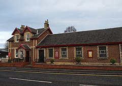
 Friendship House, Milngavie St. Andrew's Episcopal Church | |
Location within East Dunbartonshire | |
| Population | 12,795 |
| OS grid reference | NS553744 |
| Cooncil area | |
| Lieutenancy area | |
| Kintra | Scotland |
| Sovereign state | Unitit Kinrick |
| Post toun | GLASGOW [1] |
| Postcode destrict | G62 |
| Diallin code | 0141 |
| Police | Scots |
| Fire | Scots |
| Ambulance | Scots |
| EU Pairlament | Scotland |
| UK Pairlament | |
| Scots Pairlament | |
A muckle nummer o fowk in Milngavie get tae Glasgow oan the trains fae wirk an eddication. The toun is gey popular wi auld fowk that disnae wirk onymair; it haes a high nummer o senior citizens. 12,795 fowk wis written as bidin there in 2001.
The toun is best kent the nou as the stairt o the West Highland Way, a footpath runnin north for 95 mile tae Fort William.
History
eeditThe difference atween the toun's writtit an callit names comes fae the way its Scots Gaelic name wis adaptit intae Inglis. The Gaelic name fae the toun is thoucht tae hae bin Muileann Dhaibhidh ([2] "David's mill"[3][4]), wi Daibhidh cuttit tae Dàidh in plain leid,[5] giein Muileann Dhàidh. Hence the writin o "-gavie" and the callin o "-guy". The stress placement is Gaelic an aw, but cud be Scots[6].
Joan Blaeu's Atlas o Scotland shews auld spellins fae well-kent places: Milngavie is shewn as "Milgay" ("ay" bein a Scots spellin o [ae̯], cf. aye an the oreeginal callin o MacKay), meanin "Mill o Guy".[7] Anaither suggestion is the nam meant "Gavin's Mill", an Gavin's Mill is aye in the toun centur the nou.
Kent the day as a suburb of Glesga, the toun grew frae a country village within the parochine o New Kilpatrick to a smaa industrial centur in the nineteent centurie wi paper mills an bleach wirks oan the Allander Watter tae the Nor'eist o the toun centur. The Clober Industrial Estate staunds thaur the nou.
Stane villas an muckle hooses wis bildit fae rich fowk to the eist of the toun efter the railway reached Milngavie in 1863.
Efter Warld War II a hoosin scheme wis bildit tae the wast o the toun, an mony fowk frae bombed-oot hooses in Clydebank came thaur. The toun wis eikit wi private developments o bungalows an mair hooses tae the Sooth an Wast o the toun in the 1950s and 1960s. The Fairways estate wis bildit in the 1980s.
Fowk frae the toun ran a campaign tae bring the Olympic Gemmes tae Mulguy in 2020, but it wisnae ever taken seriously.[8]
References
eedit- ↑ Evox Facilities. "List of UK post towns". Evox Facilities. Archived frae the original on 19 Februar 2012. Retrieved 22 Februar 2012. Unknown parameter
|deadurl=ignored (help) - ↑ "Archived copy" (PDF). Archived frae the original (PDF) on 28 September 2011. Retrieved 20 September 2011.CS1 maint: archived copy as title (link)
- ↑ "Archived copy". Archived frae the original on 6 October 2011. Retrieved 20 September 2011.CS1 maint: archived copy as title (link)
- ↑ www.cairnwater.co.uk/faclair/?txtSearch=muileann
- ↑ Alexander MacBain, LL.D., An Etymological Dictionary of the Gaelic Language, p. 399, Stirling 1911
- ↑ "Archived copy". Archived frae the original on 21 Mairch 2012. Retrieved 20 September 2011.CS1 maint: archived copy as title (link)
- ↑ McCardel, J (1949). The Parish of New Kilpatrick. University Press Glasgow.
- ↑ "Milngavie bids to host Olympics". BBC News. 11 Apryle 2008. Retrieved 30 Julie 2009.
| This Scotland-relatit airticle is a stub. Ye can help Wikipaedia bi expandin it. |
