Kirkmaiden
Kirkmaiden is a pairish in the Rhins o Gallowa, the maist soothren in Scotland. It lies in the historical coonty o Wigtounshire, in Dumfries an Gallowa. The praisent Kirk o Scotland pairish has the same name an is awmaist the same aurie as the oreeginal pre-Reformation pairish.
Kirkmaiden
| |
|---|---|
 Kirkmaiden Location within Scotland | |
| Population | 685 (2001) |
| OS grid reference | NX1236 |
| Ceevil pairish |
|
| Cooncil area | |
| Lieutenancy area | |
| Kintra | Scotland |
| Sovereign state | Unitit Kinrick |
| Post toun | Stranraer |
| Postcode destrict | DG9 |
| Diallin code | 01776 |
| Police | Scots |
| Fire | Scots |
| Ambulance | Scots |
| EU Pairlament | Scotland |
| UK Pairlament | |
| Scots Pairlament | |
.jpg)

It is name't efter the medieval Saunt Medan whase identity, name, sex, an oreegin is threapit[1]. The name "Kirkmaiden" itsel is thocht tae be a corruption o a mair pure Gaelic Kilmaiden bi either the Scandinavians o the Angles wi a knawledge o Gaelic.[2]
It is the aurie and name o a community cooncial an aw, that meets general in Drummore an occasionally in Port Logan.
Sattlements
eeditThe're twa main sattlements in Kirkmaiden: Drummore an Port Logan. The smaw clachan o Kirkmaiden itsel, that conteens the praisent kirk, is aboot ae mile wast o Drummore.
Ecclesiastical history
eeditThe pairish kirk wis oreeginal some five mile sooth o Drummore, at a site on the Kirkburn, no faur fae the Mull o Gallowa; the name o the nearest gote, Portankill, suggests, that oreeginal mony worshippers gaed til the Mess bi boat.[1] The kirk wis dedicatit til the Virgin Mairy, an in a cove on the eastren shore o the pairish at some time bade a hermit.[3] On 15 Julie 1393 Pape Clement VII authoreesed Finlay, Abbot o Soulseat, tae annex Kirkmaiden pairish kirk in "le Rynnis" sae as tae augment the income o the aibey. [4] In 1638 the pairishoners, ceetin the disconvenience o the jurney til the kirk, siccart the biggin o a new kirk kent as Kirk Covenant o Core Hill, about ae mile wast o Drummore. The patron wis the Yerl o Stair.
Follaein the Disruption o 1843, a new kirk wis again biggit, for worshippers in the Free Kirk o Scotland, an this time in the veelage itsel, in the street noo kent as Stair Street. Early in the 20t century the twa congregtions wis reunitit. Noo worship is habitual at the kirk in Drummore, wi ae service ilk month in the simmer bein haudit at Kirk Covenant.
Airn Age an early Middle Ages
eeditA substantious earthwark, meisurin aboot 1,312 fit lang, cuts aff an aurie o aboot 141 acre at the eastren end o the Mull o Gallowa. In maist places it comprises three ditches wi medial baunks, the inby baunk bein the lairger, meisurin atween 10 fit an 13 fit in thickness an wi an ootby hicht o up tae aboot 7 fit. It is believed the rampairts mak this the lairgest Airn Age stranghaud in Breetain.[5] It is situatit about 361 yaird south-southeast o the earthwark at the Tarbet.
Aboot 361 yaird nor'nor'wast o the abuin earthwark, an situatit at the narrae isthmus atween the bays o East Tarbet an West Tarbet, an earthwark cuts across the neck o the Mull o Gallowa sooth o the pairks o the Mull ferm. The baunk is 7.5 fit wide an about 1.5 fit heich wi likely facin stanes exposed.
Late Middle Ages
eeditThe Gordons o Clanyard Castle wis pouerfu men in the aurie, an thair dochters mairit intae Kirkmaiden families.[6] Alexander Gordon o Castle Clanyard received a bell yastit in 1534 for Kirkmaiden Kirk.[7]
Killumpha Tour[8] is anither tour hoose in the pairish.
Early modren times
eeditThe population o the pairish wis 1,051 in 1755; 1,380 in the 1790s; and 1,613 in 1801.[9] In 1790 the Statistical Account reportit an abundance o fish includin eysters an lapsters; corn; cattle; pitatties an ither vegetables; hantles o thrivin baurley an aits; an lint. Trees, houiver, didna thrive. The fermers impruived thair laund wi lime that wis brocht fae Whitehaven or Ireland.[3] At that time a nummer o endouments for the puir is mentiont, includin £100 fae Andre McMurray, a merchand in Lunnon; £100 fae Andrew Mcdowal (Laird Bankton, ane o the juidges o the Coort o Session, the Mcdowal faimly wis larids o Logan); an £400 fae William Adair o Flixton;[10] aw three hid been born in the pairish. The nearest mercat wis in Stranrawer and the war three schuils and three licenced alehooses.[11]
Archaeology
eeditIn Archaelogical and Historical Collections relating to Ayrshire and Galloway (vol V, pp 62-63) bi Rev. George Wilson, it descrives thir forts:
- a) 2 across the narrae isthmus fae East Tarbert tae Wast Tarbert
- b) ane nor'wast o Wast Tarbert, no on the O.S. map
- c) Dunora or Dunorrich
- d) Three forts wi anely hints o a ditch
- e) Dunman, a lairge fort
- f) Crummag Heid, a circular stane fort
- g) Ane atween Clanyard an Logan Bay
- h) Dunichinie, a lairge circular for north o Mull o Logan
- i) Moat Hill at Drummore[12]
Dunman Fort
eeditDunman Fort is an Early Airn Age fort on the wastren shore o the Rhins. The defences alang the inby creests o the naitural gills on the northeast an sootheast consistit o a waw oreeginal 8-12 fit thick. The inby meisurment is aboot 361 fit nor'wast bi 328 fit sooth-east, bit no structurs wis veesible in the ben. The're ingangs on the north tae nor'east and sooth, wi a possible third on the north whaur a naitural terrace provides aiccess til the ben immediate ayont the end o the waw.
Wawin is veesible on the north, east, an sooth sides, an some on the east, consistin o an inby waw face and heather-kivert grummel aboot 10 fit wide. The waw that follaes the creest o a scaur ower 23 fit heich aroond the north, east, an sooth sides o the summit. The waw eelies on the north an sooth tae soothwast, an the're no veesible defences on the wast whaur the grund faws awa steep til the sea ablo.
The're fower approaches til the fort, bit anely ane, in the nor'east is faced as an ingang. A shallae howe descends the scaur a the north tae nor'east ingang, that is mart bi three lairge boolders. At the sooth ingang a naitural terrace draps skave doun the scaur intil a howe 8 fit wide wi a baunk up til aboot 10 fit thick an 2 fit heich on its ootby lip.
Crammag Heid
eeditCrammag Heid is on the wastren shore o the Rhins. It wis a circular dun or broch wi ootwarks aboot 64 fit in diameter ower all, bit its waw haes been reduced tae a bit mair nor the steid coorse o the ootby face aroond the wast. The granite facin-stanes meisur up tae aboot 3 fit in lenth bi aboot 2 fit in breid an 2 fit in hicht, an a maximum o three coorses is veesible on the nor'wast.
The inby on the wast, that is noo occupee'd bi Crammag Heid Licht, haes been raised up tae aboot 6 fit abuin the ootby face wi material fae a ditch immediate east o the dun.
The ditch is braken bi a causey aboot 8 fit wide that is faced wi granite boolders alang its sooth side. Til the north o the causey the ditch meisurs 29.5 fit in breid an varies fae 4.25 fit in deepth ootby tae 6.5 fit inby, bit til the sooth it is anely aboot 21 fit in breid an 3.6 fit in deepth. The ingang throu the ootby defence wis likely at its soothren end whaur the rampairt an ditch stap 10 fit an 16.4 fit short o the edge o the heid respective.
Aboot 65.5 fit east o the ditch the're an ootby rampairt wi an ootby ditch. At its north end the rampairt haes been reduce't til a bit mair nor a scaiterin o stanes bit taewart the sooth it is up tae about 14.5 fit thick an 1.6 fit heich. Vitrified stane wis rekivert fae the ootby rampairt.
It haed an ingang on the east whaur the waw wis at least 14.75 fit tae 19.7 fit thick.
Core Hill Fort
eeditCore Hill Fort is an Airn Age-Daurk Age fort situatit on the summit o Core Hill, immediate sooth o Kirkmaiden Kirkyaird. It meisures aboot 83 fit bi aboot 69 fit within the inby rampairt, that varies fae a law baunk aboot 11 fit thick and aboot 1.5 fit heich, til a scaur up tae abbot 7.5 fit heich ootby. A stane axe wis fund in the ben.
High Drummore Motte an Bailey
eeditThis motte an bailey is in the mid-eastren side o the Rhins. The moond is 10 fit heich, bit it is 23 fit heich til the east and pertectit on the wast bi a rampairt an ditch. The tap is aboot 40 fit in diameter, and haes a howe aboot 18 fit across an 3-4 fit deep, wi an ingang fae the east. A rampairt gangs doon the slope taewart the east wi an inby spacin o 60 fit. ON the sooth the war an ingang aboot 8 fit wide at the steid o the moond an on the sooth o the steid the rampairt is aboot 24 fit thick at the steid an 6 fit heich ootby. Atween it an the edge o the glen lies a terrace 20 fit wide near the moond, decreasin til the east whaur it is 6 fit wide. The bailey lies on the east an meisurs aboot 92 fit bi 65.6 fit within a baunk up tae 23.6 fit thick an 8.2 fit heich on the sooth that parrockit the motte.
5t - 6t century graff
eeditThis graff is kivert bi a stane leck beirin a bad-worn Laitin inscription. The oreeginal descrievin o the stane (that is noo lost) recoreds that the name Ventidus wis legible thegither wi anither ane, that translatit as "sub-deacon". It is thocht that this coud be the 5th stane fae Kirkmadrine, the graff bein o a muckle later date. A staundin stane is situated 503 yaird nor'nor'wast o Law Curghie.
Cairngaan
eeditAt Cairngaan, at the soothren tip o the Rhis, is a likely Bronze-Age fort.[13]
Kirkmaiden in the Machars
eeditA ruint kirk sooth o Port William in the Machars, near Menreith in the pairish o Glasserton, is cried "Kirkmaiden-in-Fernis". In the kirkyaird here is the graff o Captain François Thurot.
Naitural History Group
eeditA Kirkmaiden Naitural History Group is sted in Drummore, it hauds monthly inby meetins an conducts field ootins oothrou the year. It has a websteid wi photaes o its wark.[14]
Forder readin
eedit- History of the Lands and Their Owners In Galloway. P.H. M'Kerlie. New Edition. Volume 1. 1906.[15]
- Richard D Oram (2000), The Lordship of Galloway, John Donald.
- John MacQueen (2002), Place-Names in the Rhinns of Galloway and Luice Valley, Stranraer and District Local History Trust.
- W F H Nicolaisen (1976), Scottish Place-Names, Batsford, London.
- http://www.kirkmaiden-churches-drummore.com/ Archived 2020-03-28 at the Wayback Machine
Leetit biggins in Kirkmaiden
eedit- Terally, Tile Works Cottages
- K6 Telephone Kiosk, At Gateway To Mull School
- Kirkbride, Farmhouse And Steading
- Logan, Logan Botanic Garden
- Low Currochtrie, Farmhouse
- Mull Of Galloway Lighthouse, Lighthouse Keepers' Houses And Boundary Walls
- Drummore, 5 Shore Street, Ship Inn
- East Tarbet, Cottage And Quay
- Drummore, 19 Shore Street
- Kennedy's Cairn
- Logan, Bridge
- Low Drummore, Farmhouse
- Mull Hill, Beacon
- Port Logan, Laigh Row, Port Logan Lodge
- Drummore, 17 Mill Street, Ingleston
- Drummore, 33 Mill Street
- Terally Brick And Tile Works
- Longbows (Former Drummore School And Schoolhouse)
- Port Logan Lighthouse Tower And Pier
- St Agnes's (Former) Church And Manse, With Railings
- Drummore, 41 Mill Street
- Drummore, 36 And 38 Stair Street, With Railings, Gates And Gatepiers
- Terally Brick, Coal Store
- Logan Mills, Fishing Store
- Port Logan, Laigh Row (Mr Davey)
- Drummore, 57 Mill Street, Warehouse
- Drummore, 13 Shore Street, Norwood
- Drummore, 15 Shore Street, Anwoth
- Logan, Hen Knowe Cottages
- Logan Mills, Sawmill, With Water-Wheel
- Logan Windmill
- Mullhill, Farmhouse
- Mull School And Schoolhouse
- Old Parish Church Of Kirkmaiden, With Graveyard, Graveyard Walls And Gatepiers
- Port Logan, 15 Laigh Row
- Balgowan, Farmhouse
- Chapel Rossan
- Drummore, 29 And 31 Mill Street, Queen's Hotel
- Drummore, Saint Medan's Church Boundary Walls, Railings, Gates And War Memorial
- Drummore, 40 Stair Street
- Logan, Logan Court (Former Coach House And Stables)
- Port Logan School
- Castle Clanyard
- Drummore, Mill Street, Wylie's Mill, With Water-Wheel
- Drummore, 17 Shore Street
- Drummore, Stair Street, Lamb Monument
- Logan, Folly Tower
- Low Clanyard, Farmhouse
- Old Kirkmaiden House (Former Manse)
- Port Logan, 14 Laigh Row
- Port Logan Schoolhouse
- Drummore, 19 Mill Street
- Drummore, 4 Mill Street, Cairnsmore
- Killumpha, Farmhouse
- Logan House
- Logan, Logan Fish Pond, Cottage And Bathing Hut
- Auchness, Farmhouse And Cottage
- Drummore, 11 Shore Street, Tudor House
Gailerie
eedit-
 Drummore Herbour.
 -
 Mull o Gallowa.
 -
 Ruins o St Medan's chaipel and cove. location NX1431.
 -
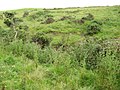 The "auld" Kirkmaiden Kirk site. location NX1332.
 -
 The "newest" Kirkmaiden Pairish Kirk, St. Medan's Kirk, Stair St, Drummore.
 -
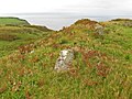
 Kirkmaiden Kirl built 1638 wi Core Hill Airn-Age fort in the backgrund.
 -
 Crammag Heid Fort site.
 -
 Dunman Fort site.
 -
 Kildonan Glen near High Drummore Motte an Bailey.
 -
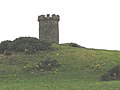 Logan windmill, Kirkmaiden, wi vautit structur at its steid.
 -
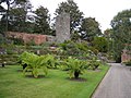 Castle Balzieland ruin in Logan Botanic Gardens.
 -
 Castle Clanyard ruin.
 -
 Wast Tarbet.
 -
 East Tarbet.


_-_geograph.org.uk_-_563692.jpg)


References
eedit- ↑ a b MacQueen (2002) pp 50 & 51.
- ↑ Nicolaisen 1976 pp 109-110
- ↑ a b Statistical Account of Scotland , vol 5, page 430; republished 1983
- ↑ See "Archived copy". Archived frae the original on 9 Februar 2012. Retrieved 18 September 2012.CS1 maint: archived copy as title (link), accessed 26 January 2008
- ↑ Neighbour, T. "Resistivity imaging of the linear earthworks at the Mull of Galloway, Dumfries and Galloway". Archaeological Prospection. 8: 157–162. doi:10.1002/arp.163.
- ↑ "Archived copy". Archived frae the original on 3 Februar 2014. Retrieved 21 November 2012.CS1 maint: archived copy as title (link)
- ↑ Kirkmaiden Church bell, AD1534 "Archived copy". Archived frae the original on 1 Februar 2014. Retrieved 21 November 2012.CS1 maint: archived copy as title (link)
- ↑ "Archived copy". Archived frae the original on 26 October 2014. Retrieved 28 Mairch 2020.CS1 maint: archived copy as title (link)
- ↑ Statistical Account of Scotland , vol 5, page xxviii; republished 1983
- ↑ There is a Flixton in Lancashire, Yorkshire and Suffolk, but none in Scotland; it is not clear where Adair was settled
- ↑ Statistical Account of Scotland, vol 5, page 432; republished 1983
- ↑ Archaeological and Historical Collections relating to Ayrshire and Galloway. vol.V. pp.62-73 https://archive.org/stream/cu31924092901606#page/n115/mode/2up
- ↑ https://archive.org/stream/proceedingssoci15unkngoog#page/n248/mode/2up
- ↑ "Archived copy". Archived frae the original on 1 Juin 2013. Retrieved 12 October 2012.CS1 maint: archived copy as title (link)
- ↑ https://archive.org/stream/historylandsand00mackgoog#page/n296/mode/2up
| Wikimedia Commons haes media relatit tae Kirkmaiden. |