Hungerford
Hungerford is a historic mercat toun an ceevil pairish in Berkshire, Ingland, centred 8 mile (13 km) wast o Newbury, 9 mile (14 km) east o Marlborough, 30 mile (48 km) northeast o Salisbury an 67 mile (107 km) wast o Lunnon. Its amenities include shops, cafés, restaurants, schuils an sports teams or clubs in the main naitional sports. It haes a railwey station which is a minor stap on the Lunnon tae Exeter (via Taunton) Line an pairt o the upper River Kennet flaes throu the toun which haes the confluence o its main river, the River Dun which is throu the toun deepest an widest as the Kennet and Avon Canal.
| Hungerford | |
|---|---|
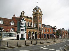
 Hungerford Town Hall | |
Location within Berkshire | |
| Area | 27.52 km2 (10.63 sq mi) |
| Population | 5,767 (2011 census)[1] |
| • Density | 210/km2 (540/sq mi) |
| OS grid reference | SU334681 |
| Ceevil pairish |
|
| Unitar authority | |
| Ceremonial coonty | |
| Region | |
| Kintra | Ingland |
| Sovereign state | Unitit Kinrick |
| Post toun | HUNGERFORD |
| Postcode destrict | RG17 |
| Diallin code | 01488 |
| Police | Thames Valley |
| Fire | Royal Berkshire |
| Ambulance | Sooth Central |
| EU Pairlament | Sooth East Ingland |
| UK Pairlament | |
