Des Moines, Iowa
Des Moines ![]() i/dᵻˈmɔɪn/ is the caipital an the maist populous ceety in the U.S. state o Iowa. It is the coonty seat o Polk Coonty an aw. A smaw portion o the ceety extends intae Warren Coonty.[5] It wis incorporatit on 22 September 1851, as Fort Des Moines which wis shortened tae "Des Moines" in 1857.[6] It is namit efter the Des Moines River, which mey hae been adaptit frae the French Rivière des Moines, meanin "River o the Monks". The ceety's population wis 203,433 as o the 2010 census.[7] The five-coonty metropolitan aurie is rankit 91st in terms o population in the Unitit States wi 599,789 residents accordin tae the 2013 estimate bi the Unitit States Census Bureau.[8]
i/dᵻˈmɔɪn/ is the caipital an the maist populous ceety in the U.S. state o Iowa. It is the coonty seat o Polk Coonty an aw. A smaw portion o the ceety extends intae Warren Coonty.[5] It wis incorporatit on 22 September 1851, as Fort Des Moines which wis shortened tae "Des Moines" in 1857.[6] It is namit efter the Des Moines River, which mey hae been adaptit frae the French Rivière des Moines, meanin "River o the Monks". The ceety's population wis 203,433 as o the 2010 census.[7] The five-coonty metropolitan aurie is rankit 91st in terms o population in the Unitit States wi 599,789 residents accordin tae the 2013 estimate bi the Unitit States Census Bureau.[8]
Des Moines, Iowa | |
|---|---|
Ceety | |
| City of Des Moines | |
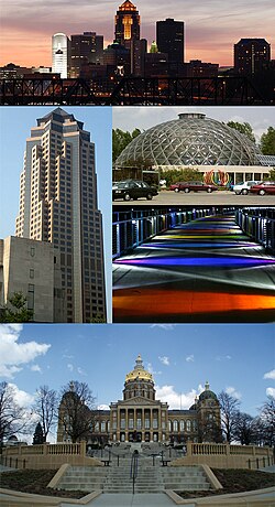
 Clockwise frae top: Skyline, Greater Des Moines Botanical Garden, Kruidenier Trail bridge, an the Iowa State Capitol, 801 Grand (Principal Financial Group) | |
 Location in Polk Coonty an in the State of Iowa | |
| Coordinates: 41°35′27″N 93°37′15″W / 41.59083°N 93.62083°W | |
| Kintra | Unitit States |
| State | Iowa |
| Coonties | Polk, Warren |
| Foondit | 1843 |
| Incorporated | 22 September 1851 |
| Govrenment | |
| • Teep | Cooncil–manager govrenment[1] |
| • Mayor | Frank Cownie |
| • Senate | Senate list
|
| • Hoose | Hoose leet
|
| • U.S. Congress | David Young (R) |
| Area | |
| • Ceety | 213.93 km2 (82.60 sq mi) |
| • Laund | 209.45 km2 (80.87 sq mi) |
| • Water | 4.48 km2 (1.73 sq mi) |
| Elevation | 291 m (955 ft) |
| Population | |
| • Ceety | 203,433 |
| • Estimate (2015[4]) | 210,330 (US: 104t) |
| • Rank | 1st in Iowa |
| • Density | 978.0/km2 (2532.9/sq mi) |
| • Metro | 622,899 (91st) |
| Time zone | UTC-6 (CST) |
| • Summer (DST) | UTC-5 (CDT) |
| ZIP codes | 50301-50340-50310 |
| Area code(s) | 515 |
| FIPS code | 19-21000 |
| GNIS featur ID | 0465961 |
| Website | www.dmgov.org |
Sister ceeties
eeditThe Greater Des Moines Sister City Commission, wi members frae the City of Des Moines an the suburbs o West Des Moines, Windsor Heights, Johnston, an Ankeny, maintains sister ceety relationships wi five warld commonties:[9]
- – Kofu, Japan (16 August 1958)
- – Saint-Étienne, Fraunce (29 Mey 1985)
- – Shijiazhuang, Cheenae (8 August 1985)
- – Stavropol, Roushie (27 Julie 1992)
- – Province o Catanzaro, Italy (26 Juin 2006)
References
eedit- ↑ "City Manager's Office". City of Des Moines – City Manager's Office. Archived frae the original on 4 November 2009. Retrieved 10 December 2009.
- ↑ "US Gazetteer files 2015". United States Census Bureau.
- ↑ "American FactFinder". United States Census Bureau. Retrieved 11 Mey 2012.
- ↑ "Population Estimates". United States Census Bureau. Archived frae the original on 2015-05-21. Retrieved May 21, 2015. Unknown parameter
|deadurl=ignored (help) - ↑ "Subcounty population estimates: Iowa 2000–2006" (CSV). United States Census Bureau, Population Division. 28 Juin 2007. Retrieved 8 Juin 2008.
- ↑ City of Des Moines. "City of Des Moines Action Center: City History". Archived frae the original on 7 December 2006. Retrieved 20 December 2006.
- ↑ "Iowa's Largest Cities". Quad City Times. 10 Februar 2011. Retrieved 13 Februar 2011.
- ↑ United States Census Bureau. "Annual Estimates of the Population of Metropolitan and Micropolitan Statistical Areas: April 1, 2010 to July 1, 2011". Retrieved 12 October 2012.
- ↑ "Greater Des Moines Sister City Commission". Office of the City Manager. Retrieved 22 Januar 2011.
Freemit airtins
eedit| Wikimedia Commons haes media relatit tae Des Moines. |
| Wikisource haes the text o the 1911 Encyclopædia Britannica airticle Des Moines. |
Travel guide tae Des Moines, Iowa frae Wikivoyage
| KML file (edit) |

