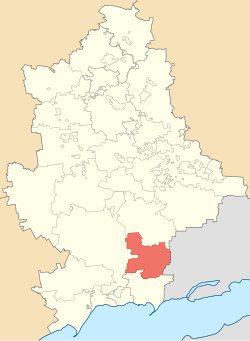
Boykivske Raion
Boykivske Raion (Ukrainian: Бойківський район, [Boykivskyi raion] error: {{lang}}: text has italic markup (help)) is ane o the 18 admeenistrative raions (a destrict) o Donetsk Oblast, locatit in sootheastren Ukraine. The admeenistrative centre o the destrict is locatit in the urban-teep dounset o Boykivske. Population: 29,550 (2013 est.)[3] Till 2016 it wis kent as Telmanove Raion namit efter the German Communist leader Ernst Thälmann.
Boykivske Raion Бойківський район | |
|---|---|
 | |
| Kintra | |
| Region | Donetsk Oblast |
| Established | 1923 |
| Disestablished | 2020 |
| Admeen. centre | Boykivske (de jure) Myrne (de facto)[1][2] |
| Subdiveesions | Leet
|
| Govrenment | |
| • Govrenor | Olga Afenkina |
| Area | |
| • Total | 812.92 km2 (313.87 sq mi) |
| Population (2013) | |
| • Total | |
| Time zone | UTC+2 (EET) |
| • Summer (DST) | UTC+3 (EEST) |
| Postal index | 87100-87182 |
| Aurie code | +380 6279 |
History
eeditAs the result o the 1951 Pols–Soviet territorial exchynge, the Soviet authorities deportit an resettled approximately 400 faimilies o Boykos frae veelage o Chorna (theday Czarna in Poland), the umwhile Nyzhni Ustryky Raion o Drohobych Oblast that wis transferred tae Poland.
On 9 Dizember 2014, the Verkhovna Rada, Ukraine's naitional pairlament, chyngit the boondars an tot aurie o the Telmanove Raion tae encompass 812.92 km2 (313.87 sq mi). The destrict's admeenistration biggins an govrenment wis muivit tae the Myrne urban-teep dounset follaein the events surroondin the War in Donbass.[1][2]
A smaw pairt o the raion on the wast bank o the Kalmius river is ower Ukrainian airmy control, frae the north ceety o Starohnativka tae the sooth ceety o Mykolaivka.
In 2016 the Verkhovna Rada renamit the raion intae Boykivske efter its admeenistrative center.
Geography
eeditThe Telmanove borders Novoazovsk Raion tae its sooth, Volodarske Raion tae its southwest, Volnovakha Raion tae its wast, Starobesheve Raion tae its north. Tae the east o the Telmanove Raion stretches the internaitional Russia-Ukraine border.
Admeenistrative diveesions
eeditThe destrict is dividit intae three dounset cooncils an twal landwart cooncils.
Demographics
eeditAccordin tae the 2001 Ukrainian Census:[4]
| Ethnicity | ||
| Ukrainians | 20,442 | 57.8% |
| Roushies | 7,359 | 20.8% |
| Greeks (Urums) | 6,172 | 17.5% |
| Tatars | 623 | 1.8% |
| Belaroushies | 165 | 0.5% |
| Germans | 152 | 0.4% |
Note: Urums are Turkic speakin Greeks. Mony o thaim wur deportit here afore the First annexation o Crimea bi the Roushie Empire frae Balaklava which ance wis a cultural centre o Pontic Greeks (see an aw Mariupol Greek).
Gallery
eedit-
Monument in Konkove (25t Anniversar o Donbas leeberation frae Nazi invaders)
-
Landscape o the Kalmius Reserve
-
Kalmius River at the Kalmius Reserve
References
eedit- ↑ a b Laws o Ukraine. Verkhovna Rada of Ukraine No. 32-VIII: Про зміни в адміністративно-територіальному устрої Донецької області, зміну і встановлення меж Волноваського, Новоазовського та Тельманівського районів Донецької області (On the changes in the administrative and territorial structure of Donetsk Oblast, changing and defining the boundaries of the Volnovakha, Novoazovsk and Telmanove Raions of Donetsk Oblast). Adoptit on 11 December 2014. (Ukrainian)
- ↑ a b "In the Donetsk Oblast three district centers removed from the territory seized by militants". Ukrayinska Pravda (in Ukrainian). 8 December 2014. Retrieved 31 December 2014.
- ↑ "Чисельність наявного населення України (Actual population o Ukraine)" (in Ukrainian). State Stateestics Service o Ukraine. Retrieved 21 Januar 2015.
- ↑ "Національний склад та рідна мова населення Донецької області" (in Ukrainian). Archived frae the original on 27 November 2012. Retrieved 7 Juin 2016. Unknown parameter
|trans_title=ignored (help); Unknown parameter|deadurl=ignored (help) "Archived copy". Archived frae the original on 3 Februar 2012. Retrieved 7 Juin 2016.CS1 maint: archived copy as title (link)

