Belen, Hatay
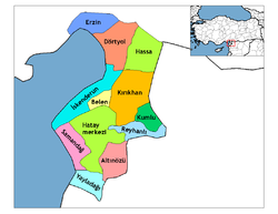
Belen is a toun an destrict o Hatay Province in the Mediterranean region o sooth-central Turkey.
Belen | |
|---|---|
Destrict | |
 Location o Belen athin Turkey. | |
| Kintra | |
| Region | Mediterranean |
| Province | Hatay |
| Govrenment | |
| • Mayor | Cemil Yılmazlar (MHP) |
| • Govrenor | Mehmet Öz |
| Elevation | 507 m (1,663 ft) |
| Population (2010) | |
| • Urban | 21,936 |
| Time zone | UTC+2 (EET) |
| • Summer (DST) | UTC+3 (EEST) |
| Postal code | 31 |
| Area code(s) | (0)326 |
| Licence plate | 31 |
| Website | www.belen.gov.tr |
Geography
eeditThe destrict o Belen consists o a sma toun o the same name an the surroondin veelages in the forestit slopes o the Nur Muntains. The Belen Pass is the main route athort the muntains an joins the coastal ceety o İskenderun wi Antakya. The pass is a key route atween Anatolie an the Middle East. The Belen destrict is kent for its ceul clean air (especially when compared wi the heat o the Mediterranean coast belaw) an its muntain spring watter.
The roadside restaurants in the pass hae lang been a stoppin place for travellers, servin the teepical dishes o Hatay, an especially "Belen tava", meats freed in tomatoes, garlic, spices an peppers.
Belen itsel is a sma mercat toun wi a post office an ither basics. The fowk o Belen are conservative; the municipality is currently (2010) controlled bi the Turkis far-richt MHP, wi the ither seats held bi the AKP.[1]
History
eeditKent in earlier times as "Maziku Bagras" an "Bab-ı İskenderun" the pass wis brocht intae the Ottoman Empire in 1516 efter the battle o Mercidabık. The Ottomans postit a guard on the pass, the main route frae Sirie tae Anatolie, an gae the aurie the name "Belen". In 1535 follaein a veesit bi Suleyman the Magnificent a wall wis biggit tae secur the pass alang wi a caravanserai, a mosque an a bathhoose, an wi thir facilities Turkis families wur settled on the muntainside, pairtly actin as watchkeepers on the pass, alang wi the military garrison. This early Ottoman airchitectur is still in place.
The toun grew, acquirin the teepical Ottoman mix o Muslim an non-Muslim traders an veelagers. the 16t century traveller Evliya Çelebi notit the hersh climate, the nairae streets an the forest on the steep hillsides. Belen wis key tae the defence o the Ottoman Empire durin the struggle against the breakaway Egyptian airmy in 1827. 13,000 lives war lost durin the Egyptian struggle tae tak the pass, thay eventually succeedit but durin thair retreat frae Anatolie wur harriet bi bandits at Belen again.
Alang wi the rest o Hatay, Belen became pairt o Turkey in 1939.
Sources
eedit- ↑ Meclis Üyeleri Archived 2010-09-29 at the Wayback Machine, Belen belediyesi