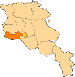
Armavir Province
Armavir (Armenie: Արմավիր) is a province (marz) o Armenie wi the caipital in Armavir. It is in the wast o the kintra, locatit in the Ararat valley, atween Munt Ararat an Munt Aragats, an shares a 45-mile mairch wi Turkey tae the sooth an wast. The province is the location o the Holy Ceety o Echmiadzin which serves as the centre o the Armenie Apostolic Kirk an the seat o the Catholicos o Armenie an o Aw Armenies. An aw locatit in this region is the historic ceety o Sardarapat, steid o the 1918 Battle o Sardarapat, a decisive event seen as no anerlie stoppin the Turkis advance intae the rest o Armenie but an aw preventin the complete destruction o the Armenie naition.[1]
Armavir Արմավիր | |
|---|---|
| Armavir Province | |
 Location o Armavir athin Armenie | |
| Coordinates: 40°09′N 44°03′E / 40.150°N 44.050°E | |
| Kintra | Armenie |
| Caipital | Armavir |
| Govrenment | |
| • Govrenor | Ashot Ghahramanyan |
| Area | |
| • Total | 1242 km2 (480 sq mi) |
| Area rank | 10t |
| Population (2009) | |
| • Total | 282,600 |
| • Rank | 3rd |
| • Density | 230/km2 (590/sq mi) |
| Time zone | UTC+04 |
| • Summer (DST) | UTC+05 |
| Postal code | 0901-1149 |
| ISO 3166 code | AM.AV |
| FIPS 10-4 | AM03 |
| Website | offeecial wabsteid |
|
Geografie
eeditArmavir haes an aurie o 1242 sq. km (4.2% o tot aurie o Armenie) makkin it the smawest province o the kintra in terms o tot aurie. It is bordered bi Turkey frae the wast an the sooth wi a lenth o 130.5 km bordrerline, whaur Arax River separates Armenie frae Turkey.
The province is mainly consistit o agricultural lands. Metsamor (or Sevjur) is the anerlie river which stairts frae the province o Armavir.
Admeenistrative borders
eeditArmavir borders the follaein marzer:
- Aragatsotn - north
- Ararat - sootheast
Tae the northeast, atween its bundaries wi Aragatsotn an Ararat, Armavir borders Yerevan an aw.
Commonties
eeditArmavir Province wis formit efter the new law o 4 September 1995, regardin the Admeenistrative-territorial diveesion o the Republic o Armenie.
As o the beginnin o 2009, the population o the urban commonties wis 101,700; formin 35.8% o he province's tot population, while the rural commonties haed a population o 182,800; formin 64.2% o the province's population.[2]
The province consists o the follaein 97 commonties (hamaynkner), o which 3 (bauld in the table) are considered urban an 94 are considered landwart.[3] The diveesion belaw is bi taratsashrjan, the admeenistrative subdiveesions o Armenie afore 4 December 1995.
Famous natives
eeditArmenie-American composer Edward Manukyan an the late Armenian pop sangster Aram Asatryan wur baith born in this region.
Gallery
eedit- Armavir
-
Saint Gayane Church, 630 AD, UNESCO Warld Heritage Steid
-
Zvartnots Cathedral, 7t century, UNESCO Warld Heritage Steid
References
eedit- Report of the results of the 2001 Armenian Census, Naitional Statistical Service o the Republic o Armenie
- ↑ Balakian, Peter. The Burning Tigris: The Armenian Genocide and America's Response. New York: HarperCollins, 2003, p. 321 ISBN 0-06-055870-9
- ↑ http://www.armavir.am/armavir.html Archived 2012-04-26 at the Wayback Machine armavir.am
- ↑ "RA Armavir Marz" (PDF). Marzes of the Republic of Armenia in Figures, 2002-2006. National Statistical Service of the Republic of Armenia. 2007.

