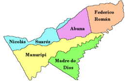
Abuná Province
Abuná is ane o the five provinces o the Bolivie depairtment o Pando an is situatit in the depairtment's northren central pairts. It haes its name frae Río Abuná, the border river tae neebourin Brazil.

| |
| Río Abuná | |
| Location in Bolivie | |
|---|---|
 | |
| General Data | |
| Caipital | Santa Rosa |
| Aurie | 7,468 km² |
| Population | 2,996 (2001) |
| Densitie | 0.4 inhabitants/km² (2001) |
| ISO 3166-2 | BO.PA.AB |
| Pando Depairtment | |
 | |
Location
eeditAroma province is locatit atween 9° 53' an 11° 06' sooth an atween 66° 27' an 67° 42' wast. It extends ower 120–250 km frae north tae sooth, an 350 km frae wast tae east.
The province is situatit in the Amazon lawlands o Bolivie an borders Brazil in the north, Nicolás Suárez Province in the northwast an wast, Manuripi Province in the sooth, an Federico Román Province in the east.
Population
eeditThe population o Abuná Province haes increased bi 40 % ower the recent twa decades:
- 1992: 2,652 inhabitants (census)
- 2001: 2,996 inhabitants (census)
- 2005: 3,475 inhabitants (est.)[1]
- 2010: 3,729 inhabitants (est.)[2]
45.4 % o the population are younger than 15 year auld. (1992)
52.3 % o the population speak Spaingie, 2.8 % speak Aymara, 2.0 % Quechua, an 52.8 speak ither indigenous leids. (1992)
The leeteracy rate o the province's population is 47.4 %. (1992)
87.6 % o the population hae nae access tae electricity, 83.6 % hae nae sanitar facilities. (1992)
83.5 % o the population are Catholics, 15.4 % are Protestants. (1992)
Diveesion
eeditThe province comprises twa municipios:
- Santa Rosa del Abuná Municipality - 3,090 km² - 2,097 inhabitants (2001)
- Ingavi Municipality - 4,378 km² - 899 inhabitants (2001)
References
eedit- ↑ Instituto Nacional de Estadística Archived 2007-08-25 at the Wayback Machine
- ↑ Instituto Nacional de Estadística - Proyecciones Archived 2008-11-18 at the Wayback Machine
Freemit airtins
eedit- General map o province Archived 2008-10-07 at the Wayback Machine
- Detailed map o province touns an rivers Archived 2008-10-09 at the Wayback Machine
- Population data (Spaingie) Archived 2008-10-10 at the Wayback Machine
- Social data (Spaingie) Archived 2008-10-09 at the Wayback Machine