Taguatinga, Federal Destrict
Taguatinga is an admeenistrative region o the Federal Destrict, Brazil. The population wis 221,909 in 2020.
Taguatinga | |
|---|---|
| Admeenistrative Region o Taguatinga | |
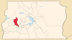
 Localization o Taguatinga in Federal Destrict | |
| Coordinates: 15°50′00″S 48°03′23″W / 15.83333°S 48.05639°W | |
| Kintra | |
| Region | Central-Wast |
| State | |
| Foondit | 05 Juin 1958 |
| Area | |
| • Total | 121,34 km2 (4,685 sq mi) |
| Elevation | 1000 m (3,000 ft) |
| Population (2020)[1] | |
| • Total | 85,491 |
| • Density | 1.8/km2 (5/sq mi) |
| Demonym(s) | Taguatinguense |
| Time zone | UTC-3 (UTC-3) |
| • Summer (DST) | UTC-2 (UTC-2) |
| Postal Code (CEP) | 72000-000 |
| Area code(s) | +55 61 |
| Website | www.taguatinga.df.gov.br |
See an aw
eeditReferences
eedit- ↑ "Pesquisa Distrital por Amostra de Domicílios - 2010/2011" (PDF) (in Portuguese). Codeplan. Retrieved 2012-20-08. Check date values in:
|accessdate=(help)[deid airtin]
Freemit airtins
eedit| Wikimedia Commons haes media relatit tae Taguatinga, Federal Destrict. |
- Page o the Regional Admeenistration o Taguatinga Archived 2020-11-27 at the Wayback Machine
- Page o the Govrenment o the Federal Destrict Archived 2014-06-25 at the Wayback Machine
Template:Admeenistrative Regions o the Federal Destrict (Brazil)

