Sur Lípez Province
Sur Lípez (or: Sud Lípez) is a province in the Potosí Depairtment in Bolivie. The seat o the province is San Pablo de Lípez.
Sur Lípez / Sud Lípez | |
|---|---|
Province | |
 | |
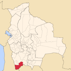
 Location o the Sud Lípez Province athin Bolivie | |
 Provinces o the Potosí Depairtment | |
| Coordinates: 22°04′0″S 67°07′0″W / 22.06667°S 67.11667°W | |
| Kintra | |
| Depairtment | Potosí Depairtment |
| Caipital | San Pablo |
| Area | |
| • Total | 22355 km2 (8,631 sq mi) |
| Population (2001) | |
| • Total | 4,905 |
| • Density | 0.3/km2 (0.8/sq mi) |
| • Ethnicities | Quechua |
Location
eeditSur Lípez is ane o saxteen provinces in the Potosí Depairtment. An aw the soothwastmaist pynt o Bolivie is locatit here, at 22° 49' 41.016" Sooth, 67° 52' 35.004" Wast, at an elevation o approximately 5,400 on the northeastren slope o the Licancabur volcano.
It is bordered bi the Nor Lípez Province in the north an northwast, Enrique Baldivieso Province in the wast, the Republic o Chile in the soothwast an sooth, the Republic o Argentinae in the sootheast an east, an Sud Chichas Province in the northeast.
The province extends frae the northeast tae the soothwast, at a lenth o 230 km an an average width o 100 km.
Geografie
eeditIn its soothwastren pairt, the Quetena Grande Canton, the province haes a couple o lakes an salt pans, the lairgest bein Laguna Colorada, which is 6 km in diameter at an elevation o 4,278 m. Ither lakes, such as Laguna Verde, Laguna Blanca an Laguna Celeste are weel kent for thair respectively green, white an blue colors an aw.
Thare is a geyser field cried "Sol de Mañana" in sooth-wastren Sur Lípez[1].
The tourist circuit La Ruta de las Joyas Altoandinas passes throu the spectacular geografie o this aurie.
Diveesion
eeditThe province comprises three municipalities which are further subdividit intae cantons.
| Section | Municipality | Seat |
|---|---|---|
| 1st | San Pablo de Lípez Municipality | San Pablo de Lípez |
| 2nt | Mojinete Municipality | Mojinete |
| 3rd | San Antonio de Esmoruco Municipality | San Antonio de Esmoruco |
Population
eeditThe population increased frae 4,158 (1992 census) tae 4,905 indwallers (2001 census), an increase o 18 %.
99.4 % o the population hae nae access tae electricity, 90 % hae nae sanitary facilities. 69 % o the population are employed in agricultur, 4 % in minin, 4 % in industrie, 23 % in general services. 86 % o the population are Catholics, 9 % Protestants.
The fowk are predominantly indigenous ceetizens o Quechua strynd.[2]
| Ethnic group | San Pablo de Lípez Municipality (%) | Mojinete Municipality (%) | San Antonio de Esmoruco Municipality (%) |
|---|---|---|---|
| Quechua | 81.5 | 98.3 | 88.4 |
| Aymara | 0.8 | 1.0 | 0.5 |
| Guaraní, Chiquitos, Moxos | 0.0 | 0.0 | 0.0 |
| Nae indigenous | 17.5 | 0.37 | 10.9 |
| Ither indigenous groups | 0.1 | 0.0 | 0.02 |
Leids
eeditThe leids spoken in the province are mainly Spaingie an Quechua.
| Leid | San Pablo de Lípez Municipality | Mojinete Municipality | San Antonio de Esmoruco Municipality |
|---|---|---|---|
| Quechua | 1,722 | 595 | 1,344 |
| Aymara | 24 | 3 | 9 |
| Guaraní | 0 | 0 | 1 |
| Anither native | 0 | 0 | 1 |
| Spaingie | 2,043 | 571 | 1,315 |
| Foreign | 9 | 0 | 0 |
| Anerlie native | 313 | 95 | 204 |
| Native an Spaingie | 1,419 | 503 | 1,146 |
| Anerlie Spaingie | 624 | 68 | 169 |
Places o interest
eeditReferences
eedit- ↑ "Sol de Mañana". Archived frae the original on 9 Februar 2012. Retrieved 6 September 2012.
- ↑ obd.descentralizacion.gov.bo
Freemit airtins
eedit- Detailed map o province touns an rivers Archived 2012-04-20 at the Wayback Machine
- Population data (Spaingie) Archived 2007-02-22 at the Wayback Machine
- Panoramic picturs o the province

