Saint-Raphaël, Var
Saint-Raphaël (pronounced [sɛ̃ ʁafaɛl]; Occitan: Sant Rafèu) is a commune in the Var depairtment in the Provence-Alpes-Côte d'Azur region in sootheastren Fraunce.
Immediately tae the wast o Saint-Raphaël lies anither, aulder, toun cried Fréjus, an thegither thay form an urban agglomeration kent as Fréjus Saint-Raphaël. The Var lies in the region cried Provence-Alpes-Côte d'Azur, aften abbreviatit tae PACA.
In the seicont hauf o the nineteent century the tounship came unner the influence o mayor Felix Martin an writer Alphonse Karr, an awin tae thair efforts an its beneficial climate the commune developed intae a seaside resort popular wi airtists, sportsmen an politeecians.
It is the heidquarters o the Fréjus Saint-Raphaël canton, which is the economic an cultural centre o eastren Var an lies in the arrondissement o Draguignan. Its indwallers are cried Raphaëlois in French generally, or Rafelencs in Provençal Occitan.
Geography
eeditSaint-Raphaël is locatit at the extreme eastren end o the Var, alang the mairch wi the adjacent département o Alpes-Maritimes, which occupees the far sooth-eastren corner o Fraunce at the frontier wi Italy. The commune haes a tot o thirty-sax kilometres o Mediterranean coastline,[1] awin mainly tae the mony coves an creeks formed atween the naitural region o the Esterel Massif an the sea. This places it seicont anerlie tae Marseilles, wi fifty-seiven kilometres o coastline. The commune is 89.59 km2 in extent. It is amaist completely urbanised in the wast, but includes ower 60 km2 o protectit auries o naitural forest an the Esterel muntains.
Saint-Raphaël haes fower lairge sandy beaches: ane near the ceety centre, cried the Veillat; ane at Boulouris; ane at Le Dramont, an the fowerth at Agay. Thare are twa smawer anes at Anthéor et Le Trayas.
Rivers
eeditSaint-Raphaël is separatit frae Fréjus bi the river Pédégal: fed bi the Garonne, the Adrets-o-l'Esterel, Saint-Jean-de-Cannes an Saint-Jean-de-l'Esterel.
The River Agay flows frae the muntains doun throu the veelage o that name, an is fed bi the streams Cabre, Perthus an Grenouillet. The Grenouillet is the maist important o thir streams, haein average flows o atween 43 cu m/s in Julie an 1160 cu m/s in Januar.
The River Valescure, which is chanelled throu the Barrage des Crous (dam), dischairges intae the River Reyran at Fréjus.
Muntains
eeditFrae east tae wast the commune haes several muntain summits risin frae the massif. Mont Vinaigre in Fréjus staunds at 618 metres (2027 ft), Rastel d'Agay at 287 m (942 ft), Pic de l'Ours (carryin a transmitter aerial) at 492 m (1614 ft), Pic du Cap Roux at 453 m (1486 ft), an Pic d'Aurèle at 322 m (1056 ft).
Situatit amaist entirely on the Esterel Massif, the commune sits on soil o reid porphyr, which maks for vera picturesque scenes alang the coast whaur the soil an rocks are exposed on cliff faces an rocky shores. Three important an spectacular rocks dominate the seascape: Cap Roux at 360 m (1181 ft), Saint-Pilon at 295 m (968 ft), an the Rock o Saint-Barthélemy.
Adjacent places
eeditImmediately tae the wast an north-wast o Saint-Raphaël lies the auncient toun o Fréjus. Tae the north lie the hamlets o Saint-Jean-de-l'Esterel et Saint-Jean-de-Cannes, baith athin the Fréjus commune. Tae the extreme north-east, ayont Le Trayas, is the sma resort o Miramar, lyin athin the commune o Théoule-sur-Mer. The Mediterranean Sea lies tae the sooth o the whole Saint-Raphaël commune.
Climate
eeditSt. Raphaël is locatit on the Côte d'Azur an enjoys a Mediterranean climate wi het, dry simmers an mild, humid winters. The Mistral wind occurs, awtho whiles the toun is sheltered frae this bi the Massif des Maures an the Esterel. It is aiblins mair exposed tae the Levant (strang, easterly, wet) or the Sirocco (vera strang, sootherly, het) air flows, but fortunately thir occur rarely. The wind velocity record wis established on 30 Januar 1986, wi gusts o 140 km per oor.
| Month | Jan | Feb | Mar | Apr | Mey | Jun | Jul | Aug | Sep | Oct | Nov | Dec | Yearly |
|---|---|---|---|---|---|---|---|---|---|---|---|---|---|
| Maximum mean temperatur (°C) | 13 | 13 | 15 | 18 | 21 | 25 | 28 | 28 | 25 | 21 | 16 | 13 | 19.6 |
| Minimum mean temperature (°C) | 3 | 4 | 5 | 7 | 10 | 14 | 16 | 16 | 14 | 11 | 6 | 3 | 9.1 |
| Average mean temperature (°C) | 8 | 9 | 10 | 13 | 16 | 19 | 22 | 22 | 19 | 16 | 11 | 8 | 14.4 |
| Sunshine (oors) | 147.8 | 148.9 | 203.2 | 252.1 | 234.9 | 280.6 | 310.3 | 355.5 | 319.5 | 247.0 | 201.5 | 145.5 | 2748.1 |
| Mean monthly precipitation (mm) | 89.6 | 85.4 | 72.3 | 62.1 | 48.7 | 37.9 | 14.6 | 42.6 | 59.0 | 117.0 | 108.9 | 85.6 | 823.4 |
| Source : Monthly Climate in Saint-Raphaël[2]. | |||||||||||||
Travel
eeditRail
eeditThe toun's modren rail station is named 'Saint-Raphaël-Valescure' an affers naitional, regional an local train services.
- High-speed TGV and iDTGV trains - frae Paris-Gare du Lyon (destination Nice);
- Corail Lunéa - frae Paris-Gare d'Austerlitz (destination Nice);
- Lines 03 and 06 of TER Provence-Alpes-Côte d'Azur - frae Marseille-Gare Saint-Charles (destination Nice);
- TER Provence-Alpes-Côte d'Azur - local stoppin service tae Nice.
Air
eeditInternaitional scheduled air passenger services are available at:
- L'aéroport Nice Côte d'Azur: fowerty-five kilometres.
- L’aéroport de Marseille Provence: 118 kilometres.
Private, commercial an freight services are conductit at:
- L'aéroport de Cannes - Mandelieu: twinty kilometres.
- L'aéroport de La Môle - Saint-Tropez: thirty-fower kilometres.
Bus
eeditSaint-Raphaël is well served bi bus routes, an haes a busy bus station in the toun centre.
- Express service bi LER PACA - Route 21: Aix-en-Provence tae Nice.
- Fast service (1 oor 15 mins) tae Nice Airport bi S.V.A. (Société Varoise d'Autocars)
- Departement (Coonty) services bi Sodetrav (La Société Départementale des Transports du Var)
- Routes 27, 28, 31, 53 an 104
- Toun services bi AggloBus Fréjus/Saint-Raphael - Routes 1a, 3, 5, 6, 7, 8, 10.
Boat
eeditThe shuttle "Boats of Saint-Raphaël" provide fast connections tae St. Aygulf, Port-Fréjus, the islands o Lerins, Saint-Tropez an Cannes.
Distances
eedit- Fréjus: 3 km (1.9 mi)
- Agay: 11 km (6.8 mi)
- Sainte-Maxime 23 km (14 mi)
- Draguignan: 33 km (21 mi)
- Saint-Tropez: 39 km (24 mi)
- Cannes: 41 km (25 mi)
- Brignoles: 66 km (41 mi)
- Nice: 66 km (41 mi)
- Toulon: 75 km (47 mi)
- Monte Carlo: 89 km (55 mi)
- Marseilles: 111 km (69 mi)
- Montpellier: 270 km (170 mi)
- Lyon: 415 km (258 mi)
- Perpignan: 419 km (260 mi)
- Paris: 695 km (432 mi)
- Bordeaux: 747 km (464 mi)
History
eeditIn 1799 Napoleon Bonaparte an his forces arrived bi ship frae Egyp, prior tae his coup d'état in Paris, an landit at a fishin veelage that wis the commune o Saint-Raphaël.
The coastal dooble-track rail link atween Saint-Raphaël an Nice passes ower a substantial viaduct constructit richt on the shoreline at Anthéor. Thir tracks wur o strategic importance tae the Axis forces durin Warld War II for supplyin matériel tae units in Fraunce.
Thare wur three separate air raids made on this viaduct frae Ingland, atween September 1943 an Februar 1944, involvin a tot o thirty-ane Lancaster bombers operatin some seiven hunder miles frae base. Aircraft o the seicont raid flew on tae Rabat, an frae the third raid on tae Sardinie. Ane Lancaster frae the first raid wis lost, an a flicht lieutenant bomb aimer on the third raid wis killed bi enemy fire, some o which came frae ships at sea. Aw the raids failed in thair objective an the rail link wis no severed.[3]
Durin Warld War II, on August 15, 1944, it wis ane o the steids o a beach landin in Operation Dragoon, the Allee'd invasion o soothren Fraunce.
Twin touns
eeditSaint-Raphaël is twinned wi:
Gallery
eedit-
 The Kirk Notre Dame de la Victoire.
 -
 The touer biggit intae the auld kirk San Rafeu.
 -
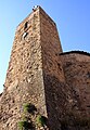 The medieval touer.
 -
 The new central bus sation adjacent tae the railwey station (Gare SNCF).
 -
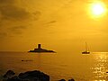 L'Ile d'Or


See an aa
eeditReferences
eedit- ↑ http://www.saint-raphael.com
- ↑ Archives climatologiques mensuelles - Saint-Raphaël (1961-1990)
- ↑ "Archived copy". Archived frae the original on 22 Juin 2001. Retrieved 31 August 2011.CS1 maint: archived copy as title (link)
Freemit airtins
eedit| Wikimedia Commons haes media relatit tae Saint-Raphaël. |
- www.ville-saintraphael.fr Archived 2020-10-08 at the Wayback Machine