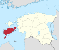
Saare Coonty
Saare Coonty (Estonie: Saare maakond), or Saaremaa, (Laitin: Osilia or Oesel; German: Ösel) is ane o 15 coonties o Estonie. It consists o Saaremaa, the lairgest island o Estonie, an several smawer islands near it, maist notably Muhu, Ruhnu, Abruka an Vilsandi. The coonty borders Lääne Coonty tae the east an Hiiu Coonty tae the north. 34,723 fowk live in Saare Coonty – constitutin 2.6% o the total population in Estonie (as o Januar 2009).[2]
Saare Coonty | |
|---|---|
 | |
| Kintra | Estonie |
| Caipital | Kuressaare |
| Govrenment | |
| • Govrenor | Kaido Kaasik [1] |
| Area | |
| • Total | 2922 km2 (1,128 sq mi) |
| Population (Januar 2009[2]) | |
| • Total | 34,723 |
| • Density | 12/km2 (31/sq mi) |
| ISO 3166 code | EE-74 |
Municipalities
eeditThe coonty is subdividit intae 3 landwart municipalities (Estonie: vallad – parishes):
Geografie
eeditThe lairgest islands o the coonty are Saaremaa, Muhu, Ruhnu, Abruka an Vilsandi. Arable land is 570 km² an it haes a mild maritime climate. The mean annual air temperatur is 6.0 °C an the mean annual precipitation is 509 mm.
Releegion
eeditThe main releegious affiliations are Lutheran, Orthodox an Baptist, but anerlie 33.6% consider thairsels releegious.[3]
References
eedit- ↑ ERR: uus maavanem näeks Saaremaal vaid üht omavalitsust (in Estonie)
- ↑ a b "Population by sex, ethnic nationality and County, 1 January". stat.ee. Statistics Estonia. 1 Januar 2009. Retrieved 18 October 2009.
- ↑ 2000 Population and Housing Census. IV. Education Completed. Religion. Estonia: Statistics Estonia. 30 Mey 2002. p. 32. ISBN 9985-74-220-6. Archived frae the original on 13 November 2010. Retrieved 18 October 2009.
Freemit airtins
eedit- Saaremaa Archived 2007-01-08 at the Wayback Machine – Offeecial wabsteid
- Saare Coonty Govrenment Archived 2008-07-31 at the Wayback Machine (in Estonie)

