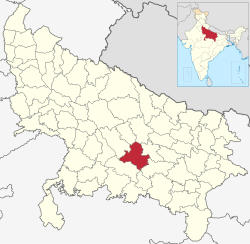
Raebareli destrict
Raebareli destrict (Hindi: रायबरेली ज़िला, Urdu: رائے بریلی ضلع) is a destrict o Uttar Pradesh state in northren Indie. The toun o Raebareli is the destrict heidquairters. The destrict is pairt o Lucknow diveesion.
Raebareli destrict रायबरेली ज़िला Uttar Pradesh | |
|---|---|
[[Destricts o {{{State}}}|Destrict o {{{State}}}]] | |
 Location o Raebareli destrict in {{{State}}} | |
| Kintra | Indie |
| State | [[{{{State}}}]] |
| Admeenistrative diveesion | Lucknow |
| Heidquairters | Raebareli |
| Govrenment | |
| • Lok Sabha constituencies | Raebareli |
| Area | |
| • Total | 4609 km2 (1,780 sq mi) |
| Population (2011) | |
| • Total | 3,404,004 |
| • Density | 740/km2 (1,900/sq mi) |
| Demographics | |
| • Leeteracy | 70 percent |
| • Sex ratio | 941 |
| Major heich-gates | NH 24B, NH 231 |
| Website | Offeecial wabsteid |
Geografie
eeditThe destrict haed a aurie o 1748 sq/m. The general aspect o the destrict is slichtly undulatin. The principal rivers o the destrict are the Ganges an the Sai: the umwhile skirts it for 54 mile an is iverywhaur navigable for boats o 40 tons; the latter traverses it frae N.W. tae S.E. The principal crops are rice, pulse, wheat, barley, millet an poppy. Rae Bareli toun is connectit wi Lucknow bi a branch o the Oudh & Rohilkhand railwey, which in 1898 wis extendit tae Benares.
Economy
eeditIn 2006 the Meenistry o Panchayati Raj namit Raebareli ane o the kintra's 250 maist backwaird destricts (oot o a tot o 640).[1] It is ane o the 34 destricts in Uttar Pradesh currently receivin funds frae the Backward Regions Grant Fund Programme (BRGF).[1]
Demographics
eeditIn 1901 the population wis 1,033,760. Accordin tae the 2011 census Raebareli destrict haes a population o 3,404,004,[2] roughly equal tae the naition o Panama[3] or the US state o Connecticut.[4] This gies it a rankin o 97t in Indie (oot o a tot o 640).[2] The destrict haes a population densitie o 739 inhabitants per square kilometre (1,910/sq mi).[2] Its population growthe rate ower the decade 2001-2011 wis 18.51%.[2] Raebareli haes a sex ratio o 941 females for ivery 1000 males,[2] an a leeteracy rate o 69.04%.[2]
Leids
eeditLeids spoken in the destrict include Awadhi, a vernacular in the Hindi continuum spoken bi ower 38 million fowk, mainly in the Awadh region.[5]
References
eedit- ↑ a b Ministry of Panchayati Raj (8 September 2009). "A Note on the Backward Regions Grant Fund Programme" (PDF). National Institute of Rural Development. Archived frae the original (PDF) on 5 Apryle 2012. Retrieved 27 September 2011.
- ↑ a b c d e f "District Census 2011". Census2011.co.in. 2011. Retrieved 30 September 2011.
- ↑ US Directorate of Intelligence. "Country Comparison:Population". Archived frae the original on 27 September 2011. Retrieved 1 October 2011.
Panama 3,460,462 July 2011 est.
- ↑ "2010 Resident Population Data". U. S. Census Bureau. Archived frae the original on 23 August 2011. Retrieved 30 September 2011.
Connecticut 3,574,097
- ↑ M. Paul Lewis, ed. (2009). "Awadhi: A language of India". Ethnologue: Languages of the World (16th ed.). Dallas, Texas: SIL International. Retrieved 28 September 2011.
- This airticle incorporates text frae a publication nou in the public domain: Chisholm, Hugh, ed. (1911). "article name needed". Encyclopædia Britannica (11th ed.). Cambridge University Press. Cite has empty unkent parameters:
|HIDE_PARAMETER15=,|HIDE_PARAMETER13=,|HIDE_PARAMETER14c=,|HIDE_PARAMETER14=,|HIDE_PARAMETER9=,|HIDE_PARAMETER3=,|HIDE_PARAMETER1=,|HIDE_PARAMETER4=,|HIDE_PARAMETER2=,|HIDE_PARAMETER8=,|HIDE_PARAMETER20=,|HIDE_PARAMETER5=,|HIDE_PARAMETER7=,|HIDE_PARAMETER10=,|separator=,|HIDE_PARAMETER14b=,|HIDE_PARAMETER6=,|HIDE_PARAMETER11=, and|HIDE_PARAMETER12=(help)CS1 maint: ref=harv (link)
Freemit airtins
eeditTemplate:Lucknow diveesion topics
Coordinates: 26°13′48″N 81°14′24″E / 26.23000°N 81.24000°E