Meta, Colombie
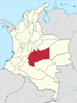
Meta is a depairtment o Colombie. It is close tae the geographic centre o the kintra, tae the east o the Andean muntains. A muckle portion o the depairtment, which is crossed bi the Meta River an aw, is covered bi a grassland plain kent as the Llanos. Its caipital is Villavicencio. The depairtment haes a monument placit in the vera geographic centre o Colombie.
Depairtment o Meta Departamento del Meta | |
|---|---|
| Motto(s): Llano Grande de Colombia y Meta | |
| Anthem: Himno de Meta (Colombia) | |
 Meta shown in red | |
| Coordinates: 4°9′N 73°38′W / 4.150°N 73.633°W | |
| Kintra | |
| Region | Orinoquía Region |
| Established | 1 Julie 1960 |
| Caipital | Villavicencio |
| Govrenment | |
| • Govrenor | Dario Vásquez Sánchez (2008-) |
| Area | |
| • Total | 85635 km2 (33,064 sq mi) |
| Area rank | 4 |
| Population (2005)[1] | |
| • Total | 789,276 |
| • Rank | 19 |
| • Density | 9.2/km2 (24/sq mi) |
| Time zone | UTC-05 |
| ISO 3166 code | CO-MET |
| Provinces | 4 |
| Municipalities | 29 |
| Website | www.meta.gov.co |
Achagua, which is seemilar tae Piapoco, is an Indigenous leid spoken bi a minority in the depairtment.
Municipalities
eeditReferences
eeditFreemit airtins
eedit- Folklore llanero Archived 2018-06-20 at the Wayback Machine
- Govrenment Meta
- Territorial-Environmental Information System o Colombie Amazon SIAT-AC wabsteid Archived 2008-11-21 at the Wayback Machine (in Spaingie)

