Loch Erie
Loch Erie[6] (/ˈɪri/; Inglis: Lake Erie, French: Lac Érié) is the fowerth lairgest loch (bi surface area) o the five Great Lochs in North Americae, an the thirteent lairgest globally if measurt in terms o surface area.[7][1]
| Loch Erie | |
|---|---|
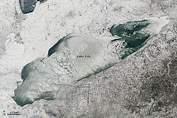
 Loch Erie on Januar 9, 2014 | |
 The Great Lochs, wi Loch Erie heichlichtit in darker blue | |
| Location | North Americae |
| Group | Great Lochs |
| Coordinates | 42°12′N 81°12′W / 42.2°N 81.2°WCoordinates: 42°12′N 81°12′W / 42.2°N 81.2°W |
| Loch teep | Glacial |
| Primary inflows | Detroit River[1] |
| Primar ootflows | Niagara River Welland Canal[2] |
| Basin kintras | Canadae Unitit States |
| Max. lenth | 241 mi (388 km) |
| Max. weenth | 57 mi (92 km) |
| Surface area | 9,910 sq mi (25,667 km2)[2] |
| Average deepth | 62 ft (19 m)[2] |
| Max. deepth | 210 ft (64 m)[3] |
| Watter vollum | 116 cu mi (480 km3)[2] |
| Residence time | 2.6 years |
| Shore lenth1 | 799 mi (1,286 km) plus 72 mi (116 km) for islands[4] |
| Surface elevation | 569 ft (173 m)[2] |
| Islands | 24+ (see list) |
| Settlements | Buffalo, New York Erie, Pennsylvania Toledo, Ohio Cleveland, Ohio |
| References | [5] |
| 1 Shore lenth is nae a weel-defined meisur. | |
References
eedit- ↑ a b State of Ohio, Division of Geological Survey, Lake Erie Facts Archived 2013-03-25 at the Wayback Machine, Accessed May 4, 2013
- ↑ a b c d e US Environmental Protection Agency, Great Lakes Factsheet No. 1 Archived 2015-03-02 at the Wayback Machine, Accessed May 4, 2013
- ↑ edited by John W. Wright with editors and reporters of the Times (2007). The New York Times 2007 almanac. New York, N.Y.: Penguin Reference. ISBN 0-14-303820-6. OCLC 75276830.CS1 maint: extra text: authors leet (link)
- ↑ Shorelines of the Great Lakes
- ↑ edited by John W. Wright with editors and reporters of the Times (2007). The New York Times 2007 almanac. New York, N.Y.: Penguin Reference. ISBN 0-14-303820-6. OCLC 75276830.CS1 maint: extra text: authors leet (link)
- ↑ United States Geological Survey Hydrological Unit Code: 04-12-02-00[citation needit]
- ↑ Large Lakes of the World. Factmonster.com.