Liberie
Coordinates: 6°30′N 9°30′W / 6.500°N 9.500°W
Liberie (![]() i/laɪˈbɪəriə/), offeecially the Republic o Liberie, is a kintra on the wast coast o Africae, bordered bi Sierra Leone, Guinea, Côte d'Ivoire, an the Atlantic Ocean. As o the 2008 Census, the naition is hame tae 3,476,608 fowk an covers 111,369 square kilometres (43,000 sq mi).
i/laɪˈbɪəriə/), offeecially the Republic o Liberie, is a kintra on the wast coast o Africae, bordered bi Sierra Leone, Guinea, Côte d'Ivoire, an the Atlantic Ocean. As o the 2008 Census, the naition is hame tae 3,476,608 fowk an covers 111,369 square kilometres (43,000 sq mi).
Republic o Liberie | |
|---|---|
Motto: "The Love Of Liberty Brought Us Here" | |
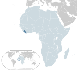
 Location o Liberie (dark blue) – in Africa (light blue & dark grey) | |
 | |
| Caipital and largest city | Monrovia 6°19′N 10°48′W / 6.317°N 10.800°W |
| Offeecial leids | Inglis |
| Spoken an naitional leids[1] | |
| Ethnic groups (2008[2]) | |
| Releegion | Christianity (85.6%), Islam (12.2%), Ithers (2.2%)[2] |
| Demonym(s) | Liberie |
| Govrenment | Unitar presidential republic |
• Preses | Joseph Boakai |
| Jeremiah Koung | |
| Johnathan K. Koffa | |
| Sie-A-Nyene Yuoh | |
| Legislatur | Legislatur o Liberie |
| Senate | |
| Hoose o Representatives | |
| Formation an Unthirldom | |
• Settlement bi the American Colonisation Society | Januar 7, 1822 |
| Julie 26, 1847 | |
• Annexation o Republic o Maryland | Mairch 18, 1857 |
• Recogneetion bi the Unitit States | Februar 5, 1862 |
| Januar 6, 1986 | |
| Aurie | |
• Total | 111,369 km2 (43,000 sq mi) (102nt) |
• Water (%) | 13.514 |
| Population | |
• 2015 estimate | 4,503,000[3] (125t) |
• 2008 census | 3,476,608 (130t) |
• Density | 40.43/km2 (104.7/sq mi) (180t) |
| GDP (PPP) | 2018 estimate |
• Total | $4.123 billion[4] |
• Per capita | $897[4] |
| GDP (nominal) | 2018 estimate |
• Tot | $2.335 billion[4] |
• Per capita | $475[4] |
| Gini (2007) | 38.2[5] medium |
| HDI (2015) | law · 177t |
| Currency | Liberie dollara (LRD) |
| Time zone | UTC+0 (GMT) |
| Drivin side | richt |
| Cawin code | +231 |
| ISO 3166 code | LR |
| Internet TLD | .lr |
Liberie's caipital is Monrovia. Liberie haes a het equatorial climate wi maist rainfall arrivin in the rainy saison wi hersh harmattan winds in the dry saison. Liberie's populated Pepper Coast is componed o maistly mangrove forests while the spairsely populatit inland is forestit, later openin tae a plateau o drier grasslands.
Etymology
eeditThe name Liberie denotes "liberty". The newly arrived settlers formed a new ethnic group cried the Americo-Liberians. Housomeivver, this introduction o a new ethnic mix resultit in ethnic tensions wi the saxteen ither main ethnicities awready residin in Liberie. Frae the 16t century till 1822, European splorers an traders haed multiple names for Liberie, varyin bi leid.
Durin the spice trade, in non-Inglis speakin Europe, Liberiae wis cawed the Malaguetta Coast or Pepper Coast in Inglis. It earned its name frae the melegueta pepper foond in rural Liberie that wis dubbed the "Grains o paradise" syne it wis a rare spice in heich demand throughoot continental Europe. In late 18t century Inglis splorers referred tae the kintra as the Windward Coast acause o notoriously unnavigable, choppy waters aff the coast o Cape Palmas at the tip o Soothren Liberie that wur difficult for European ships tae sail throu.
References
eedit- ↑ Lewis, M. Paul; Simons, Gary F.; Fennig, Charles D., eds. (2015). "Liberia". Ethnologue (18th ed.). Dallas, Texas: SIL International.
- ↑ a b "Liberia". The World Factbook. Central Intelligence Agency. Archived frae the original on 31 August 2020. Retrieved 9 Februar 2018.
- ↑ "Liberia". The World Bank country page for Liberia. The World Bank. 2015. Retrieved 4 September 2014.
- ↑ a b c d "Liberia". International Monetary Fund.
- ↑ "GINI index". World Bank. Retrieved 14 August 2015.
- ↑ "2016 Human Development Report" (PDF). United Nations Development Programme. 2016. Retrieved 21 Mairch 2017.
| Wikimedia Commons haes media relatit tae Liberia. |

