Kirkcowan
Kirkcowan is a pairish in the Machars in the historical coonty o Wigtounshire in Dumfries an Gallowa, Scotland. It is aboot 15 mile lang, an fae nearly twa tae seiven mile wide, compreesin 30,580 acre, o that 7000 acre is arable 300 acre is wuidland an plantations, an the lave is meidaes an pasturs in the Machars. The veelage o Kirkcowan is boondit on the east bi the River Blaidnoch. on the wast bi the River Tarff, an is 6 mile wast-sooth-wast fae Newtoun Stewart.
Kirkcowan
| |
|---|---|
 Kirkcowan Location within Dumfries an Gallowa | |
| Cooncil area | |
| Lieutenancy area | |
| Kintra | Scotland |
| Sovereign state | Unitit Kinrick |
| Police | Scots |
| Fire | Scots |
| Ambulance | Scots |
| EU Pairlament | Scotland |
| UK Pairlament | |
| Scots Pairlament | |

Kirkcowan pairish, wi its wide muirlands is ane on the lairger Wigtounshire auries, an a map o the pairish can be seen at the National Leebrary o Scotland, on the John Ainslie map o 1782.[1]
The principal industry haes aye been agricultur, awtho in the 19t century twa ooen mills wis biggit on the River Tarff nearby.
The A75 road that gangs throu Kirkcowan is in effect the Lunnon-Belfast road. Th road forms a pairt o the International E-road netwark as European route E18.
Thare is a Community Cooncil at Kirkcowan.[2]
Kirkcowan is on the medieval pilgrimer route tae Whithorn Priory, the seat o Christianity in Scotland.
The veelage
eeditThe veelage o Kirkcowan is on the road tae Wigtoun, an situatit atween the River Tarff an River Blaidnoch.[3]
Acause the veelage is situatit on the main Stranrawer-tae-Cairl bus route, an atween the twa rivers, it attracts mony fishers, hikers, an cyclists an aw, syne it is on the Machars Yellow Cylce Route.
The kirk, biggit in 1829 unner the patronage o Agnew faimily, is a substantious structur wi a tour. A congregation o First Seceders assemmle't for public worship in an auld barn.[4]
Kirkcowan veelage haes a post office, a nursery, a primary schuil, a veelage haw, a garage/petrol station (Kirkcowan Service station), a public hoose/hottle (Craighlaw Airms), and a photography studio rin bi waddin and limn photographer Dan Baillie.
Kirkcowan haes an aw a growein Beavers, Cubs, an Scouts troup, an thare is a thrang o beautifu places tae ventur, trails tae follae, an auries tae explore.[5]
Places o interest
eedit- Glendarroch Loch - situatit in the vicinity o the veelage o Kirkcowan an is easy aiccessible fae the A75 road, is ane o the regions's coorse fishin gems. The loch is a smaw, gin-clear estate loch that hauds a lairge heid o common roach (Rutilus rutilus), common rudd (Scardinius erythrophthalmus), an European partch (Perca fluviatilis). Common cairp (Cyprinus carpio) hae been stockit in recent years an is raiglar catcht while tench (Tinca tinca) an common bream (Abramis brama) up tae 3 pund is praisent an aw.[6]
- Loch Maberry Castle Crannog - A fortified island surroondit bi the remeens o a gey muckle drystane waw, awmaist 6 fit tae 7 fit thick an aboot 7 fit heich, parrockin an aurie aboot 112 fit x 85 fit that haes been subdividen an conteens biggins, aw except the lairgest bein o drystane. Entrys on the east an wast in the island haes been connectit bi causey tae baith the loch shore and the island til the north, that shaws evident o haein been surroondit at the watter's edge bi a law waw o lairge boolders occasionally set on thair end. A causey fae the soothwastren end o this island links wi that atween the soothren island an the shore.[7][8]
- River Blaidnoch - this river rises at Loch Maberry in the pairish o Kirkcowan, that it rins sooth tae Polbae throu.
- On its jurney sooth it is jyned by Reoch Burn as it passes throu Carseriggan Moor.
- Conteenuin is jurney it passes Isle-na-Gower an becomes a mairch atween the forestit laund at Howpless Howe an the Ring o Barfad.
- No lang efter this it is met an jyned by Black Burn. At this pynt the river is maircht on its east side bi Barnley Plantation.
- Crossin the River Blaidnoch at the stappin stanes is a single-track road that links Merk o Shennantoun wi Little Eldrig.
- No lang efter this pynt the river widens for a bit at Braid Wheel. Conteenuin on its jurney soothwart it is neist fuirdit bi Shennantoun Brig whaur the A75 road crosses it.
- Neist a body comes tae Linn Wuid an teh watterfaw at Linn o Barhoise. The wirdl "linn" refers til the puil raither nor the watterfaw.
- The river than passes Barhoise Ferm tae Barhoise Mill. In 1684, accordin tae Symson, this aurie haed a saumon fishery wi nets on the River Blaidnoch an the River Tarff.
- At Barhoise Mill, the Laird o Craichlaw haed fishin richts. Barhoise Mill is a T-shapit twa story biggin o granite, whinstane, an sclate, that is fawin intil a state o ruination. The mill wis driven bi a wheel that wis situatit at the side o the biggin. Anley the wuiden aixle o this wheel remeens. The datestane abuin the door reads 1827, bit this mill is maist certaint a rebiggin o a muckle earlier ane, mebbe connectit wi the Auld Place o Glaisnick, a ae-time nearby dwallin o the pouerful Gordon faimily o Craichlaw. The main road fae Kirkcowan tae Wigton an fae Kirkcowan tae Minnigaff via Glaisnick crosst the river juist sooth o this mill. There is stappin stanes yet at the fuirdin place east o Ring Ferm.
- Eldrig Fell Wuid Cairn - a lairge circular cairn 59 fit across an abppt 7 fit heich.[9]
- Near Shennantoun thare is a cairn merkit on OS mappin
- Boreland Mote or Motte is on OS mappin an sits at the side o the B733 road. It is aboot 20 fit heich and 100-120 fit aroond the steid.[10]
- Mindork Castle or Mondork Castle wuid hill - Thomas M'Dowall wis born c. 1500 at Mondork Castle.[11][12][13][14]
- Wuidhill - a cairn on the anent side o the road tae Mindork/Mondork Castle is an archaelogical site.[15]
History
eeditWilliam Gordon haed chairters o pairt o the barony o Craichlaw, in the pairish o Kirkcowan an coonty o Wigtoun, 17 September 1500 and 28 Januar 1506-7; ane o the launds o Larglegastell an Marklief, 10 Januar 1515-16; an anither o the launds o Auchingilbert, 4 August 1510. He mairit Janet Baillie, an wis the ancestor o the Gordons o Craighlaw.
The railwey station o the Portpatrick and Wigtownshire Joint Railway appent in 1861 bit it closed in 1965.
A mill wis upset in 1822 for the manufactur o ooeen claiths, blankets, plaidins, flannens, an plain an pilot claiths, and the dyein an dressin o thaim the saft water o the River Tarff wis weel adaptit.
Namely fowk
eedit- Thomas Hugh Milroy FRSE (1869-1950) - Scots pheesiologist an organic chemist, wish born here.
Leetit biggins in Kirkcowan
eedit- Kirkcowan Village Kirkcowan School Schoolhouse And Boundary Walls
- Mark Of Shennanton Steading
- Half Way House
- Kirkcowan Village, Main Street, The White House
- Kirkcowan Village 8 And 10 Main Street Braeside
- 42 Main Street Nursery With Gates Gatepiers And Boundary Walls
- Kirkcowan Waulk Mill Mill Building And Weaving Sheds And Stack
- Johnston's Bridge Over Tarff Water
- Kirkcowan Village 19 And 21 Main Street Fleming House
- Lincuan Bridge
- Kirkcowan Village 23 Main Street The Craighlaw Arms
- Boreland Farmhouse
- Craichlaw House
- Kirkcowan Village, Kirkcowan Parish Church (C Of S) And Boundary Walls
- Kirkcowan Village Kirkcowan Old Parish Church And Churchyard
- Kirkcowan Village Kirkland House (Former Kirkcowan Manse
- Kirkcowan Waulk Mill House
- Barhoise Mill
- Shennanton House Quadrant Walls, Gatepiers Gate And Railings
- Kirkcowan Village, Main Street, The Blue House
- Shennanton Old Bridge
- Kirkcowan Village 58 Main Street Ashley Bank
- Kirkcowan Village 69 And 71 Main Street Tarff Hotel
- Shennanton New Bridge
- Kirkcowan Village 37 Main Street Skeldon
- Kirkcowan Village 39 Main Street
- Bridge Over Bladnoch River At Glassoch
- Kirkcowan Village 13 Main Street
- Shennanton House
- Spittal Bridge
- Kirkcowan Village 31 Main Street (The Stepps)
- Kirkcowan Village 33-35 (Odd Nos) Main Street
- Barnearnie Bridge
Gailerie
eedit-
 Main street, Kirkcowan
 -
 Kirkcowan Kirk.
 -
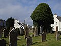 Auld Kirk, Kirkcowan.
 -
 Craighlaw Castle.
 -
 Brig til the island, Craichlaw Loch.
 -
 The Linn o Barhoise Watterfaw on the River Bladnoch.
 -
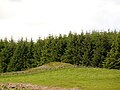
 Eldrig Fell, lairge Wuid Cairn.
 -
 White Cairn.
 -
 near Mindork or Mondork Castle ruin.
 -
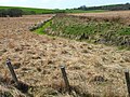
 Shennantoun. View across appen fermland at Shennantoun. Cairn in front o heich trees.
 -
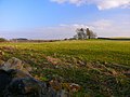
 Shennantoun. Atween twa cairns on the B735 road.
 -
 Boreland Mote or Motte.
 -
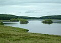
 View taewart the archaeological site on the soothren shore o Loch Ronald.
 -
 site o Loch Maberry Castle.


References
eedit- ↑ http://maps.nls.uk/counties/view/?id=685
- ↑ http://www.kirkcowan.com/community-council/
- ↑ http://www.undiscoveredscotland.co.uk/newtonstewart/kirkcowan/index.html
- ↑ A Topographical Dictionary of Scotland, Samuel Lewis, 1846.
- ↑ http://www.trailbehind.com/node/4509794/#get_quad/-4.619150161743164/54.91130708498108/14[deid airtin]
- ↑ "Archived copy". Archived frae the original on 4 Mairch 2016. Retrieved 8 Apryle 2020.CS1 maint: archived copy as title (link)
- ↑ http://canmore.rcahms.gov.uk/en/site/62444/details/loch+maberry+castle/[deid airtin]
- ↑ http://www.stravaiging.com/history/castle/loch-maberry-castle
- ↑ http://canmore.rcahms.gov.uk/en/site/62293/details/wood+cairn+eldrig+fell/[deid airtin]
- ↑ http://canmore.rcahms.gov.uk/en/site/62838/details/boreland+mote/[deid airtin]
- ↑ "Archived copy". Archived frae the original on 23 Apryle 2013. Retrieved 8 Apryle 2020.CS1 maint: archived copy as title (link)
- ↑ http://maps.nls.uk/counties/view/?id=685#id=685&zoom=6&lat=7631&lon=10012&layers=BT
- ↑ "Archived copy". Archived frae the original on 14 Mairch 2012. Retrieved 8 Apryle 2020.CS1 maint: archived copy as title (link)
- ↑ http://www.stravaiging.com/history/castle/mindork-castle
- ↑ http://www.stravaiging.com/history/castle/woodhill-kirkcowan