Huila, Colombie
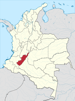
Huila (Spaingie pronunciation: [ˈwila]) is ane o the depairtments o Colombie. It is locatit in the soothwast o the kintra, an its caipital is Neiva.
Depairtment o Huila Departamento del Huila | |
|---|---|
| Anthem: Alma del Huila (Huila's soul) | |
 Huila shown in red | |
| Coordinates: 2°59′55″N 75°18′16″W / 2.99861°N 75.30444°W | |
| Kintra | |
| Region | Andes Region |
| Established | 1905 |
| Caipital | Neiva |
| Govrenment | |
| • Govrenor | Luis Jorge Sanchez (Colombian Conservative Pairty) |
| Area | |
| • Total | 19890 km2 (7,680 sq mi) |
| Area rank | 26 |
| Population (2005)[1] | |
| • Total | 1,006,797 |
| • Rank | 15 |
| • Density | 51/km2 (130/sq mi) |
| Time zone | UTC-05 |
| ISO 3166 code | CO-HUI |
| Provinces | 4 |
| Municipalities | 37 |
| Website | www.gobhuila.gov.co |
Geography
eeditThe sooth o the depairtment is locatit in the Colombie Massif. The Cordillera Oriental is born in this place.
Colombia's seicont heichest peak, the Nevado del Huila volcano, is locatit in Huila depairtment.
The Magdalena River (cried Yuma River) is Colombie's lairgest river, rises in Huila depairtment. Some o Huila's maist important touns are placit in the Magdalena River Valley. Betania is a dam locatit in the Magdalena river. A bigger dam, El Quimbo, is planned for the same river.
Airmit conflict
eeditAs o 2011 Hulia is ane o the regions maist affectit bi the Colombie airmit conflict. It is considered ane o the stranghaulds o the guerrilla muivement Fuerzas Armadas Revolucionarias de Colombia, ket as FARC-EP an aw.[2][3]
Admeenistrative diveesions
eeditMunicipalities
eedit- Acevedo
- Agrado
- Aipe
- Algeciras
- Altamira
- Baraya
- Campoalegre
- Colombia
- Elias
- Garzón
- Gigante
- Guadalupe
- Hobo
- Iquira
- Isnos
- La Argentina
- La Plata
- Nataga
- Neiva
- Oporapa
- Paicol
- Palermo
- Palestina
- Pital
- Pitalito
- Rivera
- Saladoblanco
- San Agustín
- Santa María
- Suaza
- Tarqui
- Tello
- Teruel
- Tesalia
- Timana
- Villavieja
- Yaguara
References
eedit- ↑ http://www.dane.gov.co/files/censo2005/regiones/huila/huila.pdf Population Statistics by DANE
- ↑ "Archived copy". Archived frae the original on 11 Mairch 2012. Retrieved 30 Julie 2012.CS1 maint: archived copy as title (link)
- ↑ "Archived copy". Archived frae the original on 21 Mairch 2012. Retrieved 30 Julie 2012.CS1 maint: archived copy as title (link)
Freemit airtins
eedit- (in Spaingie) Govrenment o Huila offeecial wabsteid Archived 2007-10-09 at the Wayback Machine

