Harrisburg, Pennsylvanie
Harrisburg (Pennsylvanie German: Harrisbarig) is the caipital ceety o the U.S. state o Pennsylvanie an the coonty seat o Dauphin Coonty. Wi a population o 49,673, it is the tent-lairgest ceety in the U.S. state o Pennsylvanie. It lees on the east bank o the Susquehanna River, 105 mile (169 km) wast-northwast o Philadelphia an 204 mile (328 km) east o Pittsburgh.
Harrisburg, Pennsylvanie | |
|---|---|
| City of Harrisburg | |
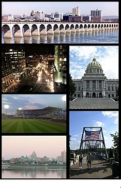
 Frae tap tae bottom, left tae richt: Harrisburg skyline; Market Square in Downtown Harrisburg; Pennsylvania State Capitol; Metro Bank Park; Walnut Street Bridge; Susquehanna River | |
| Eik-name(s): "Pennsylvanie's Caipital Ceety". | |
 Location in Dauphin Coonty an state o Pennsylvanie. | |
Location in the Unitit States | |
| Coordinates: 40°16′11″N 76°52′32″W / 40.26972°N 76.87556°WCoordinates: 40°16′11″N 76°52′32″W / 40.26972°N 76.87556°W | |
| Kintra | Unitit States |
| State | Pennsylvanie |
| Coonty | Dauphin |
| European dounset | Aboot 1719 |
| Incorporatit | 1791 |
| Chairter | 1860 |
| Foondit bi | John Harris, Sr. |
| Named for | John Harris, Sr. |
| Govrenment | |
| • Teep | Mayor-Council |
| • Mayor | Eric Papenfuse (D) |
| • Ceety Controller | Charlie DeBrunner (D) |
| • City Council | |
| • State Senate | Rob Teplitz (D) |
| • State Representative | Patty Kim (D) |
| Area | |
| • City | 26.9 km2 (11.4 sq mi) |
| • Laund | 21.0 km2 (8.1 sq mi) |
| • Water | 8.6 km2 (3.3 sq mi) |
| • Urban | 539.7 km2 (335.4 sq mi) |
| Elevation | 98 m (320 ft) |
| Population | |
| • City | 49,528 |
| • Density | 2,361/km2 (6114/sq mi) |
| • Urban | 383,008 |
| • Metro | 560,849 (95t) |
| • CSA | 1228559(49t) |
| Demonym(s) | Harrisburger |
| Time zone | UTC-5 (EST) |
| • Summer (DST) | UTC-4 (EDT) |
| ZIP codes | 17101-17113, 17120-17130, 17140, 17177 |
| Area code(s) | 717 |
| FIPS code | 42-32800[3] |
| GNIS featur ID | 1213649[4]
|
| Interstates | I-76, I-78, I-81, I-83, an I-283 |
| Watterwas | Susquehanna River |
| Primar Airport | Harrisburg Internaitional Airport- MDT (Major/International) |
| Seicondar Airport | Capital City Airport- CXY (Minor) |
| Public transit | Capital Area Transit |
| Website | www.harrisburgpa.gov |
| Designatit | September 23, 1946[5] |
References
eedit- ↑ Harrisburg City Council Accessed January 29, 2010.
- ↑ "State and county quick facts". U. S. Census Bureau. Archived frae the original on 2012-06-01. Retrieved June 2012. Check date values in:
|accessdate=(help) - ↑ "American FactFinder". United States Census Bureau. Retrieved 31 Januar 2008.
- ↑ "US Board on Geographic Names". United States Geological Survey. 25 October 2007. Retrieved 31 Januar 2008.
- ↑ "PHMC Historical Markers Search". Pennsylvania Historical and Museum Commission. Commonwealth of Pennsylvania. Archived frae the original (Searchable database) on 21 Mairch 2016. Retrieved 25 Januar 2014.
Freemit airtins
eedit- City of Harrisburg (offeecial wabsteid)
