Barraba
Barraba is a veelage in the New England region o New Sooth Wales, Australie. The veelage wis umwhile the main veelage o Barraba Shire, houiver in 1994 baith the veelage an maist o the shire wis mellt intil the Tamworth Regional Cooncil. Barraba is in the Bundarra-Barraba Important Bird Aurie that hains the habitat o the rare bird Regent Honeyeater (Anthochaera phrygia).
| Barraba New Sooth Wales | |||||||||
|---|---|---|---|---|---|---|---|---|---|
 Queen Street | |||||||||
 Barraba | |||||||||
| Coordinates | 30°22′42″S 150°36′38″E / 30.37833°S 150.61056°ECoordinates: 30°22′42″S 150°36′38″E / 30.37833°S 150.61056°E | ||||||||
| Population | 1,410 (2016)[1] | ||||||||
| Established | 1850's | ||||||||
| Elevation | 500 m (1,640 ft) | ||||||||
| Time zone | AEST (UTC+10) | ||||||||
| • Simmer (DST) | AEDT (UTC+11) | ||||||||
| Location | |||||||||
| LGA(s) | Tamworth Regional Cooncil | ||||||||
| State electorate(s) | Darling | ||||||||
| Federal Diveesion(s) | New England | ||||||||
| |||||||||
Barraba is 296 mile (477 km) nor'wast fae Sydney, 341 mile (548 km) soothwast fae Brisbane, an 56 mile (90 km) north fae Tamworth that is the nearest ceety. The Manilla River flowes aside the veelage. Barraba is on the Fossickers Way tourist road an the veelage is in the Nandewar Muntains.

History
eeditThe aboriginal Kamilaroi fowk bade in the destrict afore the comin o the Europeans.[2] The first European intil the destrict wis the explorer an botanist Allan Cunningham, that arrived there in 1827.[3] The first ferm in the destrict, Barraba Station, wis establisht in aither 1837 or 1838.[2][4] The site o the veelage wis mettit in 1852.[5]
Throu the 1850’s the diskivery o gowd helpit the wee veelage tae growe.[5] The first post office wis appent in 1856[6] an the first schuil wis appent in 1861.[2] The first Anglican kirk wis biggit in 1876[4] an the first bank was appent in 1876 an aw.[4] The first hottle, the Commercial Hotel, wis biggit in 1878[4] an the coorthoose wis biggit in 1881[4]. Barraba wis proclaimt official tae be a veelage in 1885.[4][5] The infirmary wis biggit in 1891[4] an the Methodist kirk wis biggit in 1898.[4]
The local newspaper, the Barraba Gazette, begoud publishin in 1900.[4] The Catholic kirk wis biggit in 1906.[4] The railwey cam tae Barraba in 1908,[7] houiver the lest train run tae Barraba in 1983, an the railwey wis closed in 1987.[8] The Connors Creek Dam wis biggit in 1933 sae as tae impruive the supply o watter til the veelage.[4]

Minin
eeditCapper
eeditCapper wis diskivert at Gulf Creek in 1889 an the first mine wis establisht in 1892. Gulf Creek is 14 mile (22 km) nor'east fae Barraba. A clachan wis establisht an aw, that haed a hottle, a schuil, an a post office.[2] The mine wis the mucklest capper mine in New Sooth Wales in 1901 an the clachan haed 300 residenters,[9] houiver the mine wis closed in the 1930’s. The post office wis appent in 1897 bit it wis closed in 1966.[6] The clachan wis abandont.

Asbestos
eeditAsbestos wis mine’t fae 1919 til 1983 at Woodsreef that is 10 mile (15 km) east fae Barraba. The mine wis eikit in 1974. The mine produce’t 500,000 ton o white asbestos.
The abandont mine left ahint 75,000,000 ton o waste rock an 25,000,000 ton o asbestos. The abestos heap kivers 107 acre (43 ha) an it is up till 230 fit (70 m) heich.[10]
A televeision-report in 2008 descrived the growin concern that the asbestos coud be a halth problem tae the residenters an the veesitors.[11] The Asbestos Diseases Foundation of Australia demandit that the mine site shoud be restored tae its naitural state. The Foundation demandit an aw that fowk shoud nae be alloud tae enter the mine site. A public road corsed the mine site till the road wis closed in 2013. The clachan at Woodsreef wis abandont.
The Hunter-New England Health Service unnerteuk a clamant study aboot the halth eftercasts tae the community bit it haesna been publisht yet.[12]
-
 The asbestos mine at Woodsreef
 -
 Asbestos
 -
 Asbestos fabric
 -
 Asbestosis


Diatomaceous Erd
eeditA mine o diatomaceous erd (diatomite) wis establisht in 1982.
_Monterey_Formation_at_a_diatomite_quarry_just_south_of_Lompoc.jpg)
Prospectin
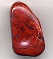
eeditPyrites, jasp, garnet, zeolite, an reid, broon, an yellae quartz is fun in the destrict. A bodie can find fossils an aw.
-
 Pyrite
 -
 Reid jasp
 -
 Garnet
 -
 Zeolite


Agricultur
eeditBeef-cattle, Merino sheep, and wheat is fermt in the destrict.
-
 Beef-cattle
 -
 Merino sheep
 -
 Wheat
Wheat


Climate
eeditBarraba experiences het an muithie simmers an the winters is cauld an dry. The heichest recordit temperatur is 41.8°C (107°F) an the lawest recordit temperatur is -9.4°C (15°F). The average yearly rainfaw is 688.7 mm (27 in) an the heichest recordit daily rainfaw is 194.3 mm (7.5 in) that fell on 25 Februar 1955.[13]
The Supply o Watter
eeditAfore the biggin o the Split Rock Dam, the veelage got its watter fae the Manilla River, Barraba Creek, an fae Connors Creek Dam. Whan thon soorces wis law, the veelage got its watter fae emergency bores.[14] [15]
The Split Rock Dam wis biggit in 1988 an a pipeline fae the dam till Barraba wis completit in 2015.
.JPG)
Gailerie
eedit-
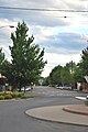 Queen Street is the main street o Barraba
 -
 the coorthoose, Barraba
 -
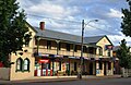 the Commercial Hotel, Barraba
 -
 the Anglican kirk, Barraba
 -
 the Methodist kirk, Barraba
 -
 the Catholic kirk, Barraba
 -
 the clocktour, Barraba
 -
 the first baunk, Barraba


References
eedit- ↑ "2016 Census QuickStats – Barraba (State Suburb)". Australian Bureau of Statistics. 6 Julie 2018. Archived frae the original on 18 October 2019. Retrieved 18 August 2018.
- ↑ a b c d "Barraba". Sydney Morning Herald Traveller. 13 November 2008. Retrieved 14 November 2011.
- ↑ "Barraba". Visit Tamworth. Tamworth Regional Council. Archived frae the original on 15 October 2011. Retrieved 14 November 2011.
- ↑ a b c d e f g h i j k "Barraba Dateline". Barraba NSW – The Community Website. Archived frae the original on 17 Mairch 2012. Retrieved 14 November 2011. Unknown parameter
|deadurl=ignored (help) - ↑ a b c Boileau, Joanna (Februar 2007). "Thematic History of Nundle, Manilla and Barraba". Tamworth Regional Council. pp. 124–125. Archived frae the original on 5 Apryle 2019. Retrieved 14 November 2011.
- ↑ a b "Post Office History". Post Office List – NSW. Premier Postal Auctions. Retrieved 14 November 2011.
- ↑ "THE BARRABA RAILWAY". The Sydney Morning Herald. National Library of Australia. 22 September 1908. p. 7. Retrieved 15 November 2011.
- ↑ Bozier, Rolfe. "Barraba Branch". NSWrail.net. Retrieved 15 November 2011.
- ↑ "MINING IN NEW SOUTH WALES". The Sydney Morning Herald. National Library of Australia. 29 Julie 1901. p. 8. Retrieved 15 November 2011.
- ↑ Woodsreef Asbestos Mine Site Rehabilitation Private Members Statement, 29 August 2008. Archived Apryle 3, 2011, at the Wayback Machine
- ↑ Abandoned asbestos mine causes community outrage
- ↑ Woodsreef health report under wraps Archived Julie 6, 2011, at the Wayback Machine
- ↑ "Climate Statistics for Barraba Post Office". Climate statistics for Australian locations. Bureau of Meteorology. Retrieved 16 November 2011.
- ↑ Barraba Water Supply Archived 2011-06-28 at the Wayback Machine
- ↑ Barraba's water supply critical
External links
eedit- (in Inglis) the local wabsteid Archived 2019-04-11 at the Wayback Machine
- (in Inglis) the Facebook wabsteid o Barraba
- (in Inglis) the "Frost over Barraba" airtsfestival Archived 2020-03-02 at the Wayback Machine
- (in Inglis) the local festival
- (in Inglis) fae the Tamworth Regional Cooncil wabsteid
- (in Inglis) fae the Fossickers Way wabsteid Archived 2021-03-05 at the Wayback Machine
- (in Inglis) video: Connors Creek Dam
- (in Inglis) video: the asbestos mine at Woodsreef
- (in Inglis) video: Split Rock Dam
- (in Inglis) Barraba at Wikivoyage