Victoria, Hong Kong
Victoria, Victoria City, or statutorily, the City of Victoria,[2] wis ane o the first urban dounsets in Hong Kong efter it became a Breetish colony in 1842. It wis initially namit Queenstown but wis suin kent as Victoria. It is aften said tae be the caipital o Hong Kong,[3][4] an amaist aw govrenment depairtments still hae thair heid offices locatit athin its leemit.
| Ceety o Victoria | |||||||||||||||
|---|---|---|---|---|---|---|---|---|---|---|---|---|---|---|---|
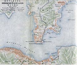
 A 1915 map shawin Victoria in the sooth | |||||||||||||||
| Traditional Chinese | 維多利亞城[1] | ||||||||||||||
| Simplified Chinese | 维多利亚城 | ||||||||||||||
| |||||||||||||||
Victoria City expandit ower hintle o what is nou Central, Sheung Wan, and Wan Chai.[5] Housomeivver, the ceety name Victoria haes been eclipsed bi Central in popular usage.[6][dubious ] It is nivertheless retained in the names o various organisations in reference tae the Victoria City, sic as the Victoria City District o the Hong Kong Scout,[7] an the Victoria Junior Chamber.[8] The name Victoria District Court haed been uised intae the 1980s,[9][10][11][12] when it wis muivit tae the Wanchai Tower an combined wi ither destrict courts in the territory.
Location
eeditThe ceety is centred in present-day Central, an namit efter Queen Victoria in 1843. It occupees the areas that are kent in modren times as Central, Admiralty, Sheung Wan, Wan Chai, East Point, Shek Tong Tsui, the Mid-levels, the Peak, Happy Valley, Tin Hau, an Kennedy Town, on Hong Kong Island. In 1903, the Hong Kong Govrenment erectit seiven boondar stanes for the ceety, inscribit "City Boundary 1903" at Hatton Road (克頓道), Pok Fu Lam Road, Bowen Road, Old Peak Road (舊山頂道), Wong Nai Chung Road, Victoria Road/Sai Ning Street (西寧街) an Magazine Gap Road. Aw remain, except for the ane in Magazine Gap Road, which disappeared aroond mid-Juin, 2007.[13][14][15]
History
eeditIn 1857, the Breetish govrenment expandit the scowp o Victoria City an dividit it intae fower "wans" (環, jyutping: waan4, pinyin: huàn, literally rings). The fower wans are Sai Wan ("Wast Ring" in Cheenese, present-day Sai Wan, includin Kennedy Town, Shek Tong Tsui, an Sai Ying Pun), Sheung Wan ("Upper Ring" in Cheenese, present-day Sheung Wan), Choong Wan or Chung Wan ("Central Ring" in Cheenese, present-day Central) an Ha Wan ("Lawer Ring" in Cheenese, present-day Wan Chai). Except "Ha Wan"; "Sai Wan", "Sheung Wan" an "Choong Wan" retain the same name in Cheenese the day.
The fower wans are further dividit intae nine "yeuks" (約, jyutping: joek3, pinyin: yuē, seemilar tae "destrict" or "neebourheid"). The coverage includit pairts o East Point an Happy Valley (Wast o Wong Nai Chung Road on the east side o the Racecourse) an aw. In 1903, boondar stanes wur establisht tae merk the Ceety's boondar an sax o thaim are still preservit the day. The stanes spread frae Causeway Bay tae Kennedy Town.[16]
In the 1890s the caipital ceety extendit 6 km wast tae east alang the coastal strip. Biggins wur made o granite an brick. Buses an the new tramwey wad acome the main form o transportation in the aurie.[17]
Destricts
eeditCried yeuks an aw.
- Shektongtsui
- Sai Ying Poon
- Taipingshan - Victoria Peak or The Peak or Moont Austin
- Sheung Wan
- Choong Wan (kent in modren times as Central in Inglis)
- Ha Wan (the day's Admiralty)
- Wan Chai
- Bowrington (atween the day's Wan Chai an Causeway Bay)
- Soo Kun Po
References
eedit- ↑ "Cap. 1 Interpretation and General Clauses Ordinance ─ Schedule 1 Boundaries of the City of Victoria". Hong Kong e-Legislation. Retrieved 19 June 2017.
- ↑ Cap 1 Sched 1 Boundaries of the City of Victoria; Interpretation and General Clauses Ordinance. Bilingual Laws Information System. Department of Justice. Accessed on 2011-04-11.
- ↑ The Hong Kong Institute of Architects Architecture Walk Central (2006), p.17
- ↑ http://www.1911encyclopedia.org/Hong-Kong
- ↑ Wordie, Jason (2002). Streets: Exploring Hong Kong Island. Hong Kong University Press. p. 12. ISBN 962-209-563-1.
- ↑ Tsang, Steve (2004). A Modern History of Hong Kong. I.B. Tauris. p. 17. ISBN 1-84511-419-1.
- ↑ Victoria City District
- ↑ Victoria Junior Chamber
- ↑ Volume 22 Inland Revenue Board of Review decisions Archived 2013-11-10 at the Wayback Machine
- ↑ CACC497/1986 The Queen v. Chan Ngai Hung
- ↑ CACC186A/1987 The Queen v Currency Brokers (H.K.) Ltd and Robert Lee Flickinger
- ↑ CACC133A/1986 The Queen v. Wai Hin Keung
- ↑ "Antiquities and Monuments Office website: "Boundary Stone, City of Victoria"". Archived frae the original on 24 October 2019. Retrieved 20 August 2013.
- ↑ List of boundary stones, with pictures Archived 2008-08-29 at the Wayback Machine (in Cheenese)
- ↑ Apple Daily article about the boundary stones, 2007-08-19 Archived 2012-03-26 at the Wayback Machine (in Cheenese)
- ↑ Wordie, Jason. [2002] (2002) Streets: Exploring Hong Kong Island. Hong Kong: Hong Kong University Press. ISBN 962-209-563-1
- ↑ Sanderson, Edgar (1897–1898). The British Empire in the nineteenth century: its progress and expansion at home and abroad. IV. London: Blackie and Son. p. 339. LCCN 02002538. OCLC 11625716.CS1 maint: date format (link)
Freemit airtins
eedit| Wikimedia Commons haes media relatit tae Victoria City. |
- Boundary of the City of Victoria as defined in Hong Kong Laws, Cap 1 SCHED 1 of Hong Kong Law
- Article on history of Hong Kong Archived 2010-06-02 at the Wayback Machine (in Cheenese)
- Photos of the 1903 boundary stones Archived 2016-03-04 at the Wayback Machine
- A article on the "four wans and nine yeuks" in Chinese Archived 2005-02-06 at the Wayback Machine (Adobe PDF format)
- Another article on "four wans and nine yeuks" Archived 2005-03-17 at the Wayback Machine (in Cheenese)
- Victoria City - Provisional Urban Council Archived 2011-07-11 at the Wayback Machine
- Victoria City - Provisional Urban Council Archived 2011-07-11 at the Wayback Machine
Coordinates: 22°16′42″N 114°10′28″E / 22.27833°N 114.17444°E