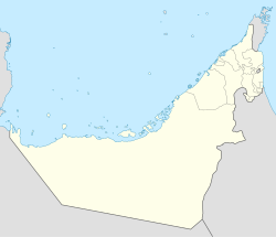
Ras al-Khaimah
Ras al-Khaimah (Arabic: رأس الخيمة Rā's al Ḫaima, Scots: The Top o the Tent) is ane o the emirates o the Unitit Arab Emirates (UAE), in the east o the Persie Gulf. It is in the northren pairt o the UAE borderin Oman's exclave. The emirate o Ras Al Khaimah covers an aurie o 1,700 square km. The caipital ceety an hame o maist residents is cried Ras al-Khaimah an aw. The ceety haes a population o 263,217 as o 2008.[1] The ceety haes twa main sections, Auld Ras Al Khaimah an Nakheel, on either side o a creek. It is servit bi the Ras Al Khaimah Internaitional Airport. Apairt frae the northren pairt whaur the ceety o Ras Al Khaimah is situatit, it haes ane lairge enclave in the sooth near Hatta an aw, an a few smaw islands on the Persie Gulf.
Ras al-Khaimah إمارة رأس الخيمة | |
|---|---|
| Emirate o Ras al-Khaimah | |
| Coordinates: 25°47′N 55°57′E / 25.783°N 55.950°E | |
| Govrenment | |
| • Teep | Absolute monarchy |
| • Emir | Saud bin Saqr al Qasimi |
| • Croun Prince | Mohammed bin Saud al Qasimi |
| Area | |
| • Total | 1683 km2 (650 sq mi) |
| Population (2008) | |
| • Total | 263,217 |
Important touns, settlements an auries include:
- Jazirat Al Hamra - an auld costal toun wi numerous real estate projects an industrial zone
- Rams – a coastal toun, in the past a typical fishermen an pearl diver veelage
- Khor Khuwair - an industrial zone, wi the lairgest port in Ras Al Khaimah an numerous companies such as cement factory
- Diqdaqah – a veelage kent for agricultur activities
- Khatt - a veelage surroondit bi the muntains, famous for its thermal springs an palm gardens
- Masafi – a toun in the soothren pairt o Ras Al Khaimah, weel kent for drinkin water
- Huwaylat - a central veelage in the soothren pairt o Ras Al Khaimah
References
eeditFreemit airtins
eedit| Wikimedia Commons haes media relatit tae Ras al-Khaimah. |

