Moroni, Comoros
The "Scots" that wis uised in this airticle wis written bi a body that haesna a guid grip on the leid. Please mak this airticle mair better gin ye can. (December 2020) |
Moroni (in Arabic موروني Mūrūnī) is the maist muckle ceity o the Comoros islands an syne 1958 haes served as its caipital. In Comorian, Moroni translates as "in the hert o the fire", aiblins alludin tae the ceity's proximity tae Munt Karthala.
Moroni Arabic: موروني Mūrūnī | |
|---|---|
 | |
 Moroni Location o Moroni on the island o Grande Comore | |
| Coordinates: 11°41′58″S 43°15′20″E / 11.699307°S 43.255692°E | |
| Kintra | |
| Island | Grande Comore |
| Caipital ceity | 1962 |
| Area | |
| • Total | 30 km2 (10 sq mi) |
| Elevation | 29 m (95 ft) |
| Population (2003 est.) | |
| • Total | 60,200 |
| • Density | 2,000/km2 (5,200/sq mi) |
| Time zone | UTC+3 (Eastren Africae Time) |
| Area code(s) | 269 |
History
eeditMoroni wis foondit bi Arabic settlers possibly durin the 10t century AD as the caipital o a sultanate connectit commercially tae Zanzibar in Tanzanie.[1]
Geography
eeditThe ceity is locatit on the wastren coast o Grande Comore (kent as N'gazidja an aa) island. Moroni is served bi the Prince Said Ibrahim Internaitional Airport (IATA airport code: HAH). Thare is an' a' a harbour wi regular transport tae the African mainland an the ither islands in the Comoros archipelago, as well as Madagascar an ither Indian ocean islands. Moroni is locatit at 11°45′S 43°12′E / 11.750°S 43.200°ECoordinates: 11°45′S 43°12′E / 11.750°S 43.200°E.
Commerce
eeditExports include vanilla, cocoa, an coffee.
Tourism
eeditMoroni haes mony excellent beaches. The Ancienne Mosquée du Vendredi (Auld Friday Mosque) is a popular tourist spot.
-
 Moroni Beach
 -
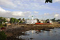 City Centre o Moroni, Capital o the Comoros, wi Central Mosque, Harbor Bay an the surroondin aurie.
 -
 Mosque wi teepical Comoro male in front o it, in the City Centre o Moroni.


Climate
eeditMoroni features a tropical rainforest climate, wi generally hivy precipitation throughoot the year. Moroni generally sees a copious amoont o precipitation throughoot the course o the year, wi ae October seein on average less nor 100 mm o rain. Lik mony ither ceities wi this climate, Moroni average temperatures throughoot the year are relatively constant. Temperatures, tho vera warm, are no quite as oppressive due in pairt tae the frequent rainfall.
| Climate data for Moroni | |||||||||||||
|---|---|---|---|---|---|---|---|---|---|---|---|---|---|
| Month | Jan | Feb | Mar | Apr | May | Jun | Jul | Aug | Sep | Oct | Nov | Dec | Year |
| Record heich °C (°F) | 34 (93) |
34 (93) |
35 (95) |
34 (93) |
33 (91) |
32 (90) |
31 (88) |
31 (88) |
31 (88) |
33 (91) |
34 (93) |
36 (97) |
36 (97) |
| Average heich °C (°F) | 30 (86) |
30 (86) |
31 (88) |
30 (86) |
29 (84) |
28 (82) |
28 (82) |
27 (81) |
28 (82) |
29 (84) |
31 (88) |
31 (88) |
29 (84) |
| Average law °C (°F) | 23 (73) |
23 (73) |
23 (73) |
23 (73) |
21 (70) |
20 (68) |
19 (66) |
19 (66) |
19 (66) |
20 (68) |
22 (72) |
23 (73) |
21 (70) |
| Record law °C (°F) | 20 (68) |
20 (68) |
20 (68) |
20 (68) |
17 (63) |
14 (57) |
14 (57) |
14 (57) |
15 (59) |
16 (61) |
18 (64) |
19 (66) |
14 (57) |
| Average precipitation mm (inches) | 345 (13.6) |
311 (12.2) |
300 (11.8) |
296 (11.7) |
233 (9.2) |
215 (8.5) |
194 (7.6) |
118 (4.6) |
117 (4.6) |
91 (3.6) |
102 (4.0) |
220 (8.7) |
2,543 (100.1) |
| Source: BBC Weather [2] | |||||||||||||
References
eedit- ↑ "Lonelyplanet.com". Lonelyplanet.com. Archived frae the original on 9 Julie 2013. Retrieved 3 Julie 2010.
- ↑ "Average Conditions Moroni, Comoros". BBC Weather. Archived frae the original on 12 Februar 2006. Retrieved 18 August 2009.
Template:Caipitals o Arab kintras
| Wikimedia Commons haes media relatit tae Moroni. |
| This Africae-relatit airticle is a stub. Ye can help Wikipaedia bi expandin it. |