Monterotondo
Monterotondo is a toun an comune in the Province o Roum, central Italy.
Monterotondo | |
|---|---|
| Comune di Monterotondo | |
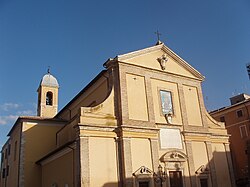
 The Cathedral o Monterotondo. | |
| Coordinates: 42°03′N 12°37′E / 42.050°N 12.617°E | |
| Kintra | Italy |
| Region | Lazio |
| Province | Roum |
| Govrenment | |
| • Mayor | Mauro Alessandri |
| Area | |
| • Total | 40 km2 (20 sq mi) |
| Elevation | 165 m (541 ft) |
| Population (31 Dizember 2004) | |
| • Total | 34,095 |
| • Density | 850/km2 (2,200/sq mi) |
| Demonym(s) | Eretini or Monterotondesi |
| Time zone | UTC+1 (CET) |
| • Summer (DST) | UTC+2 (CEST) |
| Postal code | 00015, 00016 |
| Diallin code | 06 |
| Patron saunt | Sts. Philip an James |
| Saunt day | Mey 11 |
| Website | Offeecial wabsteid |
History
eeditAccordin tae some historians, Monterotondo is the heir o auncient Sabine toun o Eretum, awtho the modren dounset appeared in the 10t-11t centuries in a different location. The name derives frae the medieval corruption (then Mons Teres, then Monte Ritondo) o the oreeginal Mons Eretum.
In the Middle Ages, due tae its location athort the Via Salaria, Monterotondo wis a strategic pynt for the defence o Roum. Initially unner the Capocci faimily, it wis sauld in the 12t century tae the Orsini, who held it till the 18t century. In 1432 it wis seizit bi the condottiero Niccolò Fortebraccio, an in 1485 it wis set on fire bi the Orsini.
In 1634 the Barberini acquired the toun, restorin or enlairgin several edifices, an biggin the Cathedral (1639). On 28 Apryle 1864 the Roum an Monterotondo Railroad wis opened for service.
In 1943, efter the Italian airmistice wi the Allees, 800 German paratroopers treed unsuccessfully tae reconquer it.
Main sichts
eedit- The Baroque Duomo (Cathedral)
- Kirk o Madonna delle Grazie
- Palazzo Orsini, includin frescoes bi Girolamo Siciolante, the Zuccari brothers an Perin del Vaga (attributit).
- Airchaeological museum, wi remains frae Eretum, Crustumerium an Nomentum.

