Jenin
You must add a |raison= parameter tae this Cleanup template – replace it wi {{Cleanup|raison=<Fill raison here>}}, or remuive the Cleanup template.
Jenin | |
|---|---|
| Ither transcription(s) | |
| • Arabic | جنين |
| • An aa spelled | Jinin (official) Janin (unofficial) |
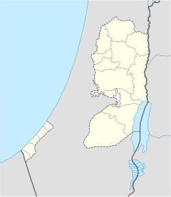
Location o Jenin within the Palestinian territories | |
| Coordinates: 32°27′40″N 35°18′00″E / 32.46111°N 35.30000°ECoordinates: 32°27′40″N 35°18′00″E / 32.46111°N 35.30000°E | |
| Palestine grid | 178/207 |
| Govrenorate | Jenin |
| Govrenment | |
| • Teep | Ceety |
| • Heid o Municipality | Hadem Rida |
| Area | |
| • Jurisdiction | 37.3 km2 (14.4 sq mi) |
| Population (2007)[1] | |
| • Jurisdiction | 39,004 |
| (plus 10,371 in Jenin refugee camp) | |
| Name meanin | The ware o gairdens[2] |
Jenin (Arabic: ![]() جنين (help·info) Ǧanīn, Hebrew: ג'נין) is the lairgest toun in the Northren Wast Bank, an the third lairgest ceety oweraw. It serves as the admeenistrative centre o the Jenin Govrenorate an is a major agricultural centre for the surroondin touns. In 2007, the ceety haed a population o 39,004[1] no includin the adjacent refugee camp (an aw namit Jenin) wi 10,371[1] residents.
جنين (help·info) Ǧanīn, Hebrew: ג'נין) is the lairgest toun in the Northren Wast Bank, an the third lairgest ceety oweraw. It serves as the admeenistrative centre o the Jenin Govrenorate an is a major agricultural centre for the surroondin touns. In 2007, the ceety haed a population o 39,004[1] no includin the adjacent refugee camp (an aw namit Jenin) wi 10,371[1] residents.
Etymology
eeditJenin wis kent in auncient times as the veelage o "Ein-Jenin" or "Tel Jenin".[3] Tell Jenin is locatit at the centre o whit is the day Jenin's business destrict.[4] The wird "'ayn" means "water spring" in Arabic an the wird "Jenin" micht be relatit tae the Arabic wird جنّة (janna), whilk means "garden".
References
eedit- ↑ a b c 2007 Locality Population Statistics Archived 2019-04-09 at the Wayback Machine. Palestinian Central Bureau of Statistics
- ↑ Palmer, 1881, p. 147
- ↑ Mariam Shahin (2005). Palestine:A Guide. Interlink Books. p. 183. ISBN 156656557X.
- ↑ Kohl et al., 2007, p. 339.
Template:Palestinian refugee camps
| This Asie-relatit airticle is a stub. Ye can help Wikipaedia bi expandin it. |
| This ceity-relatit airticle is a stub. Ye can help Wikipaedia bi expandin it. |
