File:Guyane map-fr.svg

Size of this PNG preview of this SVG file: 497 × 600 pixels. Ither resolutions: 199 × 240 pixels | 398 × 480 pixels | 637 × 768 pixels | 849 × 1,024 pixels | 1,698 × 2,048 pixels | 1,183 × 1,427 pixels.
Oreeginal file (SVG file, nominallie 1,183 × 1,427 pixels, file size: 907 KB)
Ootline
| Descreeption |
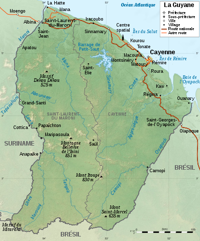
English: Map of French Guiana.
Français : Carte de la Guyane.
|
||
| Date | |||
| Soorce |
|
||
| Author | Sémhur | ||
| Other versions |
[] SVG
| ||
| Attribution (required by the license) | © Sémhur / Wikimedia Commons / | ||
| SVG | W3C-validity not checked.
|
||
| Graphic Lab |


| Camera location | | View this and other nearby images on: OpenStreetMap |
|---|
Licensin
I, the copyright holder of this work, hereby publish it under the following licenses:
| Copyleft: This wairk o airt is free; ye can redistreebute it n/or modifie it accordin til the terms o the Free Art License. Ye'll fynd ae specimen o this license oan the Copyleft Attitude steid aes weel aes oan ither steids. |
This file is licensed under the Creative Commons Attribution-Share Alike 4.0 International, 3.0 Unported, 2.5 Generic, 2.0 Generic and 1.0 Generic license.
- Ye are free:
- tae share – tae copy, distribute an transmit the wirk
- tae remix – tae adapt the wirk
- Unner the follaein condeetions:
- attribution – Ye must attribute the wirk in the manner specified bi the author or licensor (but nae in ony way that suggests that thay endorse ye or yer uise o the wirk).
- share alik – If ye alter, transform, or big upon this wirk, ye mey distribute the resultin wirk anly unner the same or seemilar license tae this ane.
Ye mey select the license o yer choice.
File history
Clap oan ae date/time fer tae see the file aes it kithed at that time.
| Date/Time | Thummnail | Dimensions | Uiser | Comment | |
|---|---|---|---|---|---|
| current | 21:10, 29 Julie 2017 | | 1,183 × 1,427 (907 KB) | Triton | correction Dekou Dekou |
| 15:44, 28 Januar 2009 |  | 1,183 × 1,427 (907 KB) | Sémhur | Correcting two labels | |
| 15:10, 28 Januar 2009 |  | 1,183 × 1,427 (907 KB) | Sémhur | {{Information |Description={{en|1=Map of French Guiana.}} {{fr|1=Carte de la Guyane.}} |Source=travail personnel (own work). Sources : * File:Guyane department relief location map.jpg by {{u|Sting}} under licence |
Eimage airtins
The follaein pages airts tae this image:
Global file uisage
The follaein ither wikis uise this file:
- Uisage on ar.wikipedia.org
- Uisage on arz.wikipedia.org
- Uisage on de.wikipedia.org
- Uisage on es.wikipedia.org
- Uisage on fr.wikipedia.org
- Liste de fleuves de France
- Guyane
- Discussion:Guyane
- Région ultrapériphérique
- Réseau routier de la Guyane
- Géographie de la Guyane
- Utilisateur:Elapied
- Massif du Mitaraka
- Discussion:Maripasoula
- Wikipédia:Atelier graphique/Cartes/Archives/janvier 2009
- Projet:Cartographie/Cartes standards/France
- Jean-Louis Loubère
- Patrimoine juif des départements, régions et territoires d’Outre-Mer
- Tampok
- Ouaqui
- Utilisateur:Peperwhite
- Utilisateur:Exp JC/Brouillon
- Uisage on fr.wikinews.org
- Uisage on fr.wikiversity.org
- Uisage on gcr.wikipedia.org
- Uisage on it.wikipedia.org
- Uisage on mg.wikipedia.org
- Uisage on nl.wikipedia.org
- Uisage on pcd.wikipedia.org
- Uisage on pl.wikipedia.org
- Uisage on ro.wikipedia.org
- Uisage on stq.wikipedia.org
- Uisage on to.wikipedia.org
- Uisage on www.wikidata.org