Deir al-Asad
Deir al-Asad (Arabic: دير الأسد) is a veelage in the Galilee region o Israel, 49 kilometres frae Haifa. It is locatit abuin al-Araas muntain. Aw the residents are Muslims. The nummer o the residents in 2003 wis approximately 8,400.
Deir al-Asad דייר אל-אסד دير الأسد | |
|---|---|
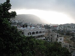
 View of Deir al-Asad, Carisa Lea, 2007 | |
| Kintra | Israel |
| Destrict | North |
| Area | |
| • Total | 4.8 km2 (1.9 sq mi) |
| Population (2003) | |
| • Total | 8,400 |
| Time zone | UTC+2 (IST) |
| • Summer (DST) | UTC+3 (IDT) |
History
eeditDeir al-Asad's name literally means "the lion's monastery" in Arabic.[1] In the late 19t century, it wis describit as a veelage o 600 Muslims, containin a few ruins. It wis surroondit bi olive-trees an arable land, wi a spring nearby.[2]
The toun is maistly populatit bi the Asadi an Dabbah faimilies. Accordin tae the 1931 Breetish census, Deir al-Asad haed 858 Muslim residents livin in 179 hooses.[3] Bi 1945, Deir el Asad haed 1,100 indwallers, aw classifee'd as Arabs. Thay awned a tot o 8,366 dunams o land, while 7 dunams wur public.[4]
Palestinian naitional poet Mahmoud Darwish wis educatit in the veelage. The veelage providit sanctuary tae Uri Davis for a year while he wis evadin airmy service.
Afore 1962 the veelage o Deir al-Asad wis self-sufficient in fuid. It producit enough meat, fruit, wheat an vegetables for itsel an sauld the surplus in Acre or Nazareth. In 1962 its land in the Majd al-Kurum valley wis confiscated for the Carmiel toun project, an the veelage wis tharebi stripped o its maist fertile acres. Anerlie the hill land tae the north, consistin mainly o olive groves, remained. In ane blow the economy o Deir al-Asad wis ruined. The day anerlie 10% o the labour force can wirk on the land, ower 80% hae tae commute daily tae the factories o Haifa or wirk as labourers on Jewish ferms.[5][6]
In 2003, the municipality o Deir al-Asad mergit wi Majd al-Krum an Bi'ina tae form the ceety o Shaghur. Housomeivver, it wis reinstatit in 2008 efter Shaghur wis dissolvit.
References
eedit- ↑ Palmer, 1881, p. p.42
- ↑ Conder an Kitchener, 1881, SWP, p. 150
- ↑ E. Mills, ed. (1932). Census of Palestine 1931. Population of Villages, Towns and Administrative Areas. Jerusalem: Government of Palestine. pp. 100–101.
- ↑ Government of Palestine, Department of Statistics. Village Statistics, April, 1945. Quoted in S. Hadawi, Village Statistics, 1945. PLO Research Center, 1970 p. 40.
- ↑ Gilmour, 1983, p. 108.
- ↑ Amun, Davis, and San´allah, 1977, pp. 4–5.
Bibliography
eedit- Amun, H.; Davis, U.; San´allah, N. D. (1977). Deir al-Asad: The Destiny of an Arab Village in Galilee, in Palestinian Arabs in Israel: Two Case Studies. London: Ithaca Press.
- Conder, Claude Reignier an H.H. Kitchener (1881): The Survey of Western Palestine: memoirs of the topography, orography, hydrography, and archaeology. Lunnon:Committee o the Palestine Exploration Fund. vol 1, cairt III
- Gilmour, David (1983). Dispossessed: The Ordeal of the Palestinians. United Kingdom: Sphere Books.
- Hadawi, Sami (1970), Village Statistics of 1945: A Classification of Land and Area ownership in Palestine, Palestine Liberation Organization Research Center
- Palmer, E. H. (1881): The survey of Western Palestine: Arabic and English name lists collected during the survey by Lieutenants Conder and Kitchener, R. E. Transliterated and explained by E.H. Palmer.
- Pringle, Denys (1993), The Churches of the Crusader Kingdom of Jerusalem: A-K (excluding Acre and Jerusalem), Cambridge University Press .p.80 -92