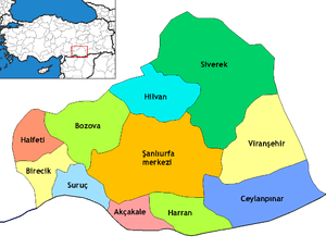
Ceylanpınar
Ceylanpınar is a maistly Kurdish populatit toun an destrict o Şanlıurfa Province in sootheastren Turkey. On the mairch wi Sirie, it is reached bi a lang straucht road D.905 athort the plain sooth frae Viranşehir. Thare is a border crossin tae the toun o Ra's al-'Ayn in Sirie.
Ceylanpınar | |
|---|---|
| Coordinates: 36°51′00″N 40°03′00″E / 36.85000°N 40.05000°E | |
| Kintra | |
| Region | Sootheastren Anatolie |
| Province | Şanlıurfa |
| Area | |
| • City | 2003 km2 (773 sq mi) |
| Population (2000) | |
| • City | 69,774 |
| • Density | 38.8/km2 (100/sq mi) |
| • Urban | 44,258 |
| Time zone | UTC+2 (EET) |
| • Summer (DST) | UTC+3 (EEST) |
| Postal code | 63xxx |
| Area code(s) | +(90)414 |
| Website | www.yerelnet.org.tr |

The destrict covers an aurie o 2,003 km2 (773 sq mi) an haes a population o 69,774 (2000 census), o whom 44,258 live in the toun o Ceylanpınar itsel.[1]
Climate
eeditCeylanpınar haes a semi-arid climate. Simmers are extremely het wi virtually noae rain at aw, winters tend tae be ceul but can acome vera cauld due tae northeasterly winds.
| Climate data for Ceylanpınar | |||||||||||||
|---|---|---|---|---|---|---|---|---|---|---|---|---|---|
| Month | Jan | Feb | Mar | Apr | May | Jun | Jul | Aug | Sep | Oct | Nov | Dec | Year |
| Average heich °C (°F) | 11 (52) |
13 (55) |
18 (64) |
23 (73) |
30 (86) |
37 (99) |
40 (104) |
40 (104) |
36 (97) |
28 (82) |
20 (68) |
13 (55) |
26 (78) |
| Average law °C (°F) | 0 (32) |
1 (34) |
4 (39) |
8 (46) |
12 (54) |
17 (63) |
20 (68) |
19 (66) |
15 (59) |
10 (50) |
4 (39) |
1 (34) |
9 (49) |
| Average precipitation mm (inches) | 70 (2.8) |
66 (2.6) |
62 (2.4) |
44 (1.7) |
22 (0.9) |
0 (0) |
0 (0) |
0 (0) |
0 (0) |
22 (0.9) |
44 (1.7) |
69 (2.7) |
399 (15.7) |
| Average precipitation days | 12 | 11 | 11 | 10 | 7 | 0 | 0 | 0 | 0 | 5 | 9 | 11 | 76 |
| Source: Weatherbase [2] | |||||||||||||
