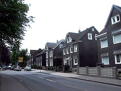
Burscheid
Burscheid is a toun in the Rheinisch-Bergischer destrict, in North Rhine-Westphalie, Germany. The toun is kent for its sub-commonties (somewha equivalent tae the American concept o neebourheids) an the toun centre wi its mercatplace an kirks.
Burscheid | |
|---|---|
 | |
| Coordinates: 51°06′00″N 07°07′00″E / 51.10000°N 7.11667°ECoordinates: 51°06′00″N 07°07′00″E / 51.10000°N 7.11667°E | |
| Kintra | Germany |
| State | North Rhine-Westphalie |
| Admin. region | Köln |
| Destrict | Rheinisch-Bergischer Kreis |
| Subdivisions | 89 |
| Govrenment | |
| • Mayor | Stefan Caplan (CDU) |
| Area | |
| • Total | 27.38 km2 (10.57 sq mi) |
| Elevation | 88 - 251 m (−735 ft) |
| Population (2021-12-31)[1] | |
| • Total | 18,681 |
| • Density | 680/km2 (1,800/sq mi) |
| Time zone | CET/CEST (UTC+1/+2) |
| Postal codes | 51399 |
| Diallin codes | 02174 |
| Vehicle registration | GL |
| Website | www.burscheid.de |
Economy
eeditThe twa lairgest employers in Burscheid are Federal Mogul GmbH (umwhile kent as Goetze AG) an Johnson Controls.
Govrenment
eeditHans Dieter Kahrl (CDU) wis first electit as Bürgermeister (mayor) in 1999. He wis reelectit in a general election on 26 September 2004 wi 51.6 % o the vote.
The current ceety cooncil wis electit wi the follaein brakdoun o poleetical affiliations (again, as o the 2004 general election):
- CDU, 2,932 votes, 40.0 % (1999: 47.4 %)
- SPD, 1,989 votes, 27.2 % (28.4 %)
- Grüne, 745 votes, 10.2 % (6.5 %)
- UWG, 884 votes, 12.1 % (8.5 %)
- FDP, 767 votes, 10.5 % (9.2 %)
Transportation
eeditBurscheid is on the A1 Autobahn, an federal heich-gate (Bundesstraße) 51 travels throu the toun. The Verkehrsverbund Rhein-Sieg an Verkehrsverbund Rhein-Ruhr baith operate bus lines that stap in Burscheid.
Neebourin commonties
eeditBurscheid is athin 15 kilometers o baith Solingen an Leverkusen.
Sub-commonties
eeditBellinghausen - Benninhausen - Berghamberg - Berringhausen - Blasberg - Dierath - Dünweg - Dürscheid - Großbruch - Großhamberg - Grünscheid - Heddinghofen - Hilgen - Kaltenherberg - Kämersheide - Kippekofen - Kleinhamberg - Kuckenberg - Lungstraße - Nagelsbaum - Oberlandscheid - Oberwietsche - Ösinghausen- Repinghofen - Rötzinghofen - Sträßchen.
Hilgen (or Burscheid-Hilgen) is the seicont lairgest an maist significant sub-commonty, next tae the main toun center (Burscheid itsel). Hilgen is on the toun's mairch wi Wermelskirchen an haes mony o its awn shops an restaurants. Maist sub-commonties in Burscheid are easily reachable bi fuit or bicycle.
Services
eeditBurscheid haes its awn public schuils, soummin puil, polis force, an volunteer fire depairtment.
Tourist steids
eedit- Haus Landscheid is a umwhile estate that belangit tae the knicht Heinrich von Nesselrode in 1731. It wis the steid o a restaurant frae 1983 tae 1998, but haes been abandoned syne 1998. Nae new uises o the property hae been planned or hae come forrit.
- The Lambertsmühle (Lamberts Mill) is in the Wiehbach valley in the soothwast o the toun, an haes been a museum syne 1994. The mill's main exhibit is entitled "The Path frae Grain tae Bread."
- The Paffenlöher Steffi (in the neebourin commonty o Paffenlöh) is a local dance club.
References
eedit- ↑ "Bevölkerung der Gemeinden Nordrhein-Westfalens am 31. Dezember 2021" (in German). Landesbetrieb Information und Technik NRW. Retrieved 20 Juin 2022.
Freemit airtins
eedit| Wikimedia Commons haes media relatit tae Burscheid. |
- Offeecial steid (in German)


