Angra do Heroísmo
Angra do Heroísmo (Portuguese pronunciation: [ˈɐ̃ɡɾɐ ðu eɾuˈiʒmu]), locally referred tae as Angra, is a municipality an ceety (o approximately 21,300 fowk) on the island o Terceira, athin the Portuguese autonomous region o the Azores. The municipal aurie haes a population o 35,581 an an aurie o 239.0 km2 (92.3 sq mi). Alang wi Praia da Vitória tae the north, it is ane o twa municipal admeenistrative diveesions that are comprised bi Terceira. Thegither wi Ponta Delgada (São Miguel) an Horta (Faial), Angra is ane o the three regional caipitals o the Azores. Each caipital is responsible for ane o the three branches o govrenment; Angra is the location o the judicial branch (the Supreme Court o the Azores), in addition tae bein the releegious centre o the Airchdiocese o Azores.
| Angra do Heroísmo | |||
| Municipality (Concelho) | |||
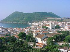
Historic ceety center o Angra do Heroísmo, wi the cinder cone Monte Brasil, as seen leukin towards the sooth coast o Terceira
| |||
|
|||
| Offeecial name: Concelho da Angra do Heroísmo | |||
| Name oreegin: angra Portuguese for cove; wis re-baptizit Angra do Heroísmo efter the Leeberal Wars, for its heroism against the tyranny o Miguelist forces: herorísmo is Portuguese for heroism; Angra do Heroísmo is literally Cove o Heroism | |||
| Nickname: Angra | |||
| Kintra | |||
|---|---|---|---|
| Autonomous Region | |||
| Group | Central | ||
| Island | Terceira | ||
| Municipality | Angra do Heroísmo | ||
| Ceevil Parishes | Altares, Cinco Ribeiras, Doze Ribeiras, Feteira, Nossa Senhora da Conceição, Porto Judeu, Posto Santo, Raminho, Ribeirinha, Santa Bárbara, Santa Luzia, São Bartolomeu de Regatos, São Bento, São Mateus da Calheta, São Pedro, Sé, Serreta, Terra Chã, Vila de São Sebastião | ||
| Laundmerks | Monte Brasil, Santa Bárbara Volcano | ||
| Centre | Sé | ||
| - elevation | 31 m (102 ft) | ||
| - coordinates | 38°29′19″N 27°13′15″W / 38.48861°N 27.22083°WCoordinates: 38°29′19″N 27°13′15″W / 38.48861°N 27.22083°W | ||
| Heichest pynt | Santa Bárbara | ||
| - location | Santa Bárbara, Santa Bárbara, Angra do Heroísmo | ||
| - elevation | 1,023 m (3,356 ft) | ||
| - coordinates | 38°43′48″N 27°19′12″W / 38.73000°N 27.32000°W | ||
| Lowest point | Sea level | ||
| - location | Atlantic Ocean | ||
| - elevation | 0 m (0 ft) | ||
| Lenth | 27.99 km (17 mi), Wast-East | ||
| Width | 18.20 km (11 mi), North-Sooth | ||
| Area | 239 km2 (92 sq mi) | ||
| Population | 35,103 (2001) | ||
| Density | 146.87/km2 (380/sq mi) | ||
| LAU | Concelho/Câmara Municipal | ||
| - location | Praça Velha, Sé | ||
| Preses | Andreia Martins Cardoso da Costa (PS) | ||
| Municipal Chair | Ricardo Manuel Rodrigues de Barros (PS) | ||
| Timezone | Azores (UTC-1) | ||
| - summer (DST) | Azores (UTC0) | ||
| ISO 3166-2 code | PT- | ||
| Postal Zone | 9701-101 Angra do Heroísmo | ||
| Aurie Code & Prefix | (+351) 292 XXX-XXXX | ||
| UNESCO Warld Heritage Steid | |||
| Name | Central Zone o the Toun o Angra do Heroismo in the Azores | ||
| Year | 1983 (#7) | ||
| Number | 206 | ||
| Region | Europe an North Americae | ||
| Criteria | iv, vi | ||
| Demonym | Terceirense; Angrense | ||
| Patron Saunt | São João | ||
| Municipal Address | Praça Velha 9701-101 Angra do Heroísmo | ||
| Municipal Holidays | 24 Juin | ||
Location o the municipality o Angra do Heroísmo in the airchipelago o the Azores
| |||
| Wikimedia Commons: Angra do Heroísmo | |||
| Website: http://www.cm-ah.pt | |||


