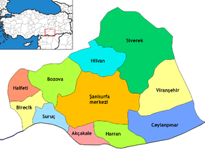
Akçakale
Akçakale is a toun an destrict o Şanlıurfa Province in sooutheastren Turkey. It is a border checkpoint on the road D.885 frae Şanlıurfa tae Tell Abyad in Sirie.
Akçakale | |
|---|---|
| Coordinates: 36°42′39.60″N 38°56′52.80″E / 36.7110000°N 38.9480000°E | |
| Kintra | |
| Region | Sootheastren Anatolie |
| Province | Şanlıurfa |
| Area | |
| • City | 1952 km2 (754 sq mi) |
| Population (2012)[1] | |
| • Urban | 28,684 |
| • Destrict | 91731 |
| Time zone | UTC+2 (EET) |
| • Summer (DST) | UTC+3 (EEST) |
| Postal code | 63xxx |
| Area code(s) | +(90)414 |
| Website | Şanlıurfa Province Administrative District of Akçakale |


Mony faimilies in the region hae relatives athort the mairch in Sirie.
Climate
eedit| Climate data for Akcakale | |||||||||||||
|---|---|---|---|---|---|---|---|---|---|---|---|---|---|
| Month | Jan | Feb | Mar | Apr | May | Jun | Jul | Aug | Sep | Oct | Nov | Dec | Year |
| Average heich °C (°F) | 10 (50) |
13 (55) |
17 (62) |
23 (73) |
29 (84) |
35 (95) |
39 (102) |
38 (100) |
35 (95) |
27 (80) |
19 (66) |
12 (53) |
25 (76) |
| Average law °C (°F) | 1 (33) |
2 (35) |
5 (41) |
9 (48) |
13 (55) |
18 (64) |
21 (69) |
20 (68) |
16 (60) |
11 (51) |
5 (41) |
2 (35) |
10 (50) |
| Average precipitation mm (inches) | 91 (3.6) |
69 (2.7) |
69 (2.7) |
48 (1.9) |
25 (1) |
2.5 (0.1) |
0 (0) |
0 (0) |
0 (0) |
23 (0.9) |
43 (1.7) |
79 (3.1) |
449.5 (17.7) |
| Source: Weatherbase [2] | |||||||||||||
References
eedit- ↑ "Population of province/district centers and towns/villages by districts - 2012". Address Based Population Registration System (ABPRS) Database. Turkish Statistical Institute. Retrieved 27 Februar 2013.
- ↑ "Weatherbase: Historical Weather for Akcakale, Turkey". Weatherbase. 2011. Archived frae the original on 6 Januar 2012. Retrieved 24 August 2012. Retrieved on November 24, 2011.
