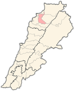
Zgharta Destrict

Zgharta Destrict (Arabic: زغرتا‎) is a destrict (qadaa) o the North Govrenorate, Lebanon.

Zgharta Destrict
Destrict
زغرتا
Location in Lebanon
Location in Lebanon
Kintra Lebanon
GovrenorateNorth Govrenorate
CaipitalZgharta
Area
 • Total182 km2 (70 sq mi)
Time zoneUTC+2 (EST)
 • Summer (DST)+3

The admeenistrative centre is the toun o Zgharta. The destrict haes 57 populatit auries wi 30 municipalities coverin 37 veelages. Some auries share the same municipality sic as Ehden/Zgharta, Kfarsghab/Morh Kfarsghab or Miziara/Harf Miziara. Thare is ane Municipalities Union an aw.

The destrict spreads frae near the coast at 40 meters abuin sea level up tae 2,800 meters o altitude at its heichest pynt. The heichest populatit pairt o the destrict is owerleukin the Qozhaya Valley, the northren branch o the Holy Valley, Qadisha, a UNESCO Heritage Steid. The destrict haes an aw the Horsh Ehden Nature Reserve. This pairt o the destrict is heichlie touristic, especially the aurie aroond the Monastery o Mar Sarkis, Ehden an the Monastery o Qozhaya.

Agricultur stays the main activity o the destrict wi an important olive ile production in the coastal aurie an fruits (aiple an pears) in the muntain aurie. The recent years saw the development o a modest service sector aroond the economic pole o Zgharta.

The offeecially registered persons in the destrict are estimatit tae 90,000 (est. 1998). Aroond 50% o the destrict population lives in the economic pole o Zgharta: Zgharta, Rachiine, Kfardlakos, Kfarhata, Mijdlayiah, Ardeh, Harf Ardeh. The majority o the population is Maronite Catholics, wi a minority o Greek Orthodox, Armenies, Sunnite Muslims an ithers.

Touns an veelages eedit

Veelage Arabic name GPS Coord Population 1998
Aarjes Arabic: عرجس 34°19′51″N 35°52′53″E / 34.33083°N 35.88139°E / 34.33083; 35.88139 (Aarjes)
Aintourine Arabic: عينتورين 34°17′06″N 35°57′25″E / 34.28500°N 35.95694°E / 34.28500; 35.95694 (Aintourine)
Aitou Arabic: أيطو 34°18′31″N 35°55′11″E / 34.30861°N 35.91972°E / 34.30861; 35.91972 (Aitou)
Alma Arabic: علما
Arbet Kozhaya Arabic: عربة قزحيا 34°17′42″N 35°55′32″E / 34.29500°N 35.92556°E / 34.29500; 35.92556 (Arbet Kozhaya)
Ardeh Arabic: ارده
Ashash Arabic: عشاش
Aslout Arabic: اسلوت
Asnoun Arabic: اصنون 34°23′15″N 35°53′11″E / 34.38750°N 35.88639°E / 34.38750; 35.88639 (Asnoun)
Bane
Basloukit Arabic: بسلوقيط
Bchennine Arabic: بشنين
Beit Awkar Arabic: بيت عوكر
Beit Obeid Arabic: بيت عبيد
Besbeel
Bhairet Toula Arabic: بحيرة تولا 34°19′23″N 35°58′15″E / 34.32306°N 35.97083°E / 34.32306; 35.97083 (Bhairet Toula)
Bnachii Arabic: بنشعي 34°19′58″N 35°53′43″E / 34.33278°N 35.89528°E / 34.33278; 35.89528 (Bnachii)
Bousit
Daraya Arabic: داريا 34°19′44″N 35°52′07″E / 34.32889°N 35.86861°E / 34.32889; 35.86861 (Daraya)
Ehden Arabic: أهدن
Ejbeh Arabic: اجبع 34°18′33″N 35°56′37″E / 34.30917°N 35.94361°E / 34.30917; 35.94361 (Ejbeh)
Fraydiss
Haret Al Fawar
Harf Ardeh
Harf Miziara Arabic: حرف مزيارة 34°20′06″N 35°56′23″E / 34.33500°N 35.93972°E / 34.33500; 35.93972 (Harf Miziara)
Hawqa Arabic: حوقا 34°16′20″N 35°56′30″E / 34.27222°N 35.94167°E / 34.27222; 35.94167 (Hawqa)
Hilan
Houmeiss Arabic: حميص 34°19′43″N 35°55′59″E / 34.32861°N 35.93306°E / 34.32861; 35.93306 (Houmeiss)
Iaal Arabic: ايعال 34°22′N 35°55′E / 34.367°N 35.917°E / 34.367; 35.917 (Iaal)
Jdaydeh
Kadrieh
Karahbache Arabic: قره باش 34°23′37″N 35°53′40″E / 34.39361°N 35.89444°E / 34.39361; 35.89444 (Karahbache)
Karmsaddeh Arabic: كرمسدة 34°18′21″N 35°53′23″E / 34.30583°N 35.88972°E / 34.30583; 35.88972 (Karmsaddeh)
Kfardlakos
Kfarfou Arabic: كفرفو 34°19′05″N 35°52′48″E / 34.31806°N 35.88000°E / 34.31806; 35.88000 (Kfarfou)
Kfarhawra
Kfarsghab Arabic: كفرصغاب 34°16′42″N 35°57′44″E / 34.27833°N 35.96222°E / 34.27833; 35.96222 (Kfarsghab)
Kfarshakhna
Kfarhata Arabic: كفرحاتا 34°22′58″N 35°53′51″E / 34.38278°N 35.89750°E / 34.38278; 35.89750 (Kfarhata)
Kfaryachit Arabic: كفرياشيت 34°20′46″N 35°53′40″E / 34.34611°N 35.89444°E / 34.34611; 35.89444 (Kfaryachit)
Kfarzeina
Khaldieh
Kifraya
Mazraat En Nahr Arabic: المزرعه النهر 34°16′50″N 35°53′54″E / 34.28056°N 35.89833°E / 34.28056; 35.89833 (Mazraat En Nahr)
Mazraat Al Toufah
Mazraat Hraikis Arabic: مزرعة حريقص
Mejdlaya
Miriata
Miziara Arabic: مزيارة 34°19′58″N 35°55′49″E / 34.33278°N 35.93028°E / 34.33278; 35.93028 (Miziara)
Morh Kfarsghab Arabic: مرح كفرصغاب 34°20′11″N 35°54′12″E / 34.33639°N 35.90333°E / 34.33639; 35.90333 (Morh Kfarsghab)
Rachiine
Raskifa Arabic: راسكيفا 34°18′38″N 35°52′01″E / 34.31056°N 35.86694°E / 34.31056; 35.86694 (Raskifa)
Sakhra Arabic: صخرا
Sebhel Arabic: سبعل 34°18′53″N 35°54′31″E / 34.31472°N 35.90861°E / 34.31472; 35.90861 (Sebhel)
Sereel Arabic: سرعل 34°17′24″N 35°54′41″E / 34.29000°N 35.91139°E / 34.29000; 35.91139 (Sereel)
Toula Arabic: تولا 34°19′03″N 35°57′49″E / 34.31750°N 35.96361°E / 34.31750; 35.96361 (Toula)
Zgharta Arabic: زغرتا

References eedit

Template:Zgharta Destrict