Potosí
Potosí is a ceety an the caipital o the Potosí Depairtment in Bolivie. It is ane o the heichest ceeties in the warld bi elevation at a nominal 4,090 metre (13,420 ft)[1] an it wis the location o the Spaingie colonial mint.
Potosí | |
|---|---|
 | |
| Eik-name(s): Empire Ville (Villa Imperial in Spainyie) | |
| Coordinates: 19°35′S 65°45′W / 19.583°S 65.750°W | |
| Kintra | Bolivie |
| Depairtment | Potosí |
| Province | Tomás Frías |
| Municipality | Potosí Municipality |
| Foondit | 1 Aprile 1545 |
| Govrenment | |
| • Mayor | Zenón Gutiérrez |
| Area | |
| • Total | 118.218 km2 (45.6 sq mi) |
| Elevation | 4067 m (13,343 ft) |
| Population (2007) | |
| • Total | 164,481 |
| Time zone | UTC-4 |
| Website | www.potosi.bo |
| Template:Designation leet | |
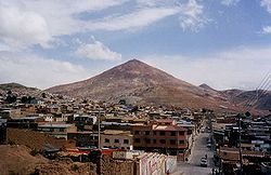
Potosí lees beneath the Cerro de Potosí—sometimes referred tae as the Cerro Rico ("rich muntain")—a muntain popularly conceivit o as being "made o" siller ore, which haes aaways dominatit the ceety. The Cerro Rico is the raison for Potosí's historical importance, syne it wis the major supply o siller for Spain durin the period o the New Warld Spaingie Empire.
The silver wis taken bi llama an mule train tae the Paceefic coast, shippit north tae Panama Ceety, carriet bi mule train athort the isthmus o Panama tae Nombre de Dios or Portobelo whence it wis taken tae Spain on the Spaingie treasur fleets. Cerro de Potosí's peak is 4,824 metre (15,827 ft) abuin sea level.
References
eedit- ↑ Bolivia & Main Cities / Potosí Archived 2008-12-06 at the Wayback Machine from boliviaweb.com. Retrieved 2010-09-27.
Specific:
Freemit airtins
eedit| Wikimedia Commons haes media relatit tae Potosí. |


