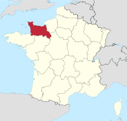
Lawer Normandy
Lawer Normandy (French: Basse-Normandie, IPA: [bas nɔr.mɑ̃.di]; Norman: Basse-Normaundie) is an admeenistrative region o Fraunce. It wis creatit in 1956, when the Normandy region wis dividit intae Lawer Normandy an Upper Normandy. The region includes three depairtments, Calvados, Manche an Orne, that cover the pairt o Normandy traditionally termit "Lawer Normandy" lyin wast o the Dives River, the Pays d'Auge (except a sma pairt remainin in Upper Normandy), a sma pairt o the Pays d'Ouche (the main pairt remainin in Upper Normandy), the Norman Perche an pairt o the "French" Perche. It covers 10,857 km2, 3.2 percent o the surface aurie o Fraunce.[1]
Lawer Normandy Basse-Normandie | |
|---|---|
 | |
| Kintra | |
| Prefectur | Caen |
| Departments | |
| Govrenment | |
| • Preses | Laurent Beauvais (PS) |
| Area | |
| • Total | 17589 km2 (6,791 sq mi) |
| Population (2007-01-01) | |
| • Total | 1,453,000 |
| • Density | 83/km2 (210/sq mi) |
| Time zone | UTC+1 (CET) |
| • Summer (DST) | UTC+2 (CEST) |
| NUTS Region | FR2 |
| Website | cr-basse-normandie.fr |
The traditional destricts o Lawer Normandy include the Cotentin Peninsulae an La Hague, the Campagne de Caen, the Norman Bocage, the Bessin an the Avranchin.
References
eedit- ↑ (Northcutt, 1996, p. 181)
Freemit airtins
eedit- Offeecial wabsteid
- (in Inglis) Lower Normandy at Curlie
