La Tablada
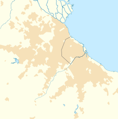
La Tablada is a ceety in Argentinae. It is locatit in La Matanza Partido an is pairt o the Greater Buenos Aires metro aurie.
La Tablada | |
|---|---|
Location in Greater Buenos Aires | |
| Coordinates: 34°41′S 58°32′W / 34.683°S 58.533°WCoordinates: 34°41′S 58°32′W / 34.683°S 58.533°W | |
| Kintra | |
| Province | |
| Partido | La Matanza |
| Foondit | 1909 |
| Elevation | 11 m (36 ft) |
| Population | |
| • Total | 80,389 |
| • Density | 8453/km2 (21,890/sq mi) |
| CPA Base | B 1766 |
| Area code(s) | +54 11 |
Owerview
eeditLa Tablada initially developit aroond the Buenos Aires Western Railway (Spaingie: Ferrocarril Oeste de Buenos Aires) station inauguratit in 1900. The station, locatit on the 28 km (18 mi) marker alang the Haedo—La Plata line, primarily servit the wholesale mercat established nearbi in 1901, an in 1909, the dounset's first hamesteid lots wur sauld.[1]
Maist o the dounset's 1,500 early hameawners wirkit in the wholesale mercat which wis closely tied to the Liniers cattle merca juist north o La Tablada, an numerous meat packin plants opened in the toun durin the 1910s an 1920s. Provincial electricity services an the toun's first clinic wur established in 1925.[1]
The ceety grew moderately yet steadily in subsequent decades, an became hame tae the third-lairgest business an industrial commonty in La Matanza Coonty. The important La Tablada Regiment wis the steid o an attack in Januar 1989 bi members o the left-wing Movimiento Todos por la Patria. La Tablada wis declared a ceety bi the Provincial Legislatur on 11 November 1993.[1]
References
eedit| Wikimedia Commons haes media relatit tae La Tablada. |
